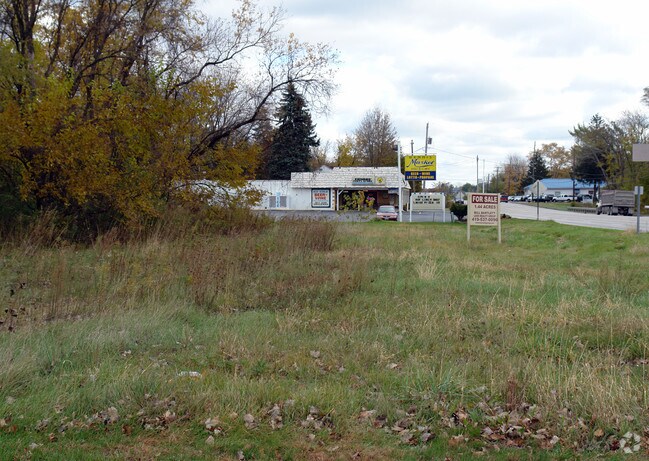
Property Record
8900 Airport Hwy, Holland, OH 43528
NEARBY LISTINGS FOR SALE OR LEASE
-
-
View all Holland listings for sale on LoopNet.com
Property Detail
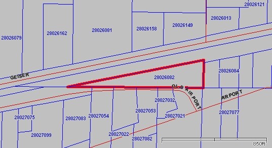
8900 Airport Hwy
65-20364
2 18 SW 1/4 TRI SE COR S OF N Y C R/WEXC E 15 FT
Commercialnec
Lucas
AE
Ohio
39095C0207E
5.03 AC
2024
South/Southwest
2024
Toledo
009104
Toledo, OH
390 SF
DEMOGRAPHICS near 8900 Airport Hwy
1 Mile
3 Mile
5 Mile
2024 Total Population
925
20,075
69,791
2029 Population
901
19,534
68,836
Pop Growth 2024-2029
(2.59%)
(2.69%)
(1.37%)
Average Age
42
43
42
2024 Total Households
318
7,738
29,721
HH Growth 2024-2029
(2.83%)
(2.80%)
(1.24%)
Median Household Inc
$83,522
$96,335
$71,169
Avg Household Size
2.60
2.50
2.30
2024 Avg HH Vehicles
2.00
2.00
2.00
Median Home Value
$223,140
$259,612
$221,172
Median Year Built
1991
1991
1985
Nearby Places
Map Layers
Map Styles
 Street
 Aerial
- Restaurants
- Banks
- Shops
- Fitness
- Groceries
PUBLIC TRANSPORTATION
AIRPORT
Eugene F Kranz Toledo Express
DRIVE
WALK
Distance
Eugene F Kranz Toledo Express
17 min
7.5 mi
Freight Ports
Port of Toledo
DRIVE
WALK
Distance
Port of Toledo
32 min
17.6 mi
Nearby Properties
Address
Land Use
TOTAL SIZE
Lot Size
Zoning
Address
Land Use
TOTAL SIZE
Lot Size
Zoning
186,190 SF
14 AC
19-C2
Address
Land Use
TOTAL SIZE
Lot Size
Zoning
372,117 SF
35 AC
17-AR
Address
Land Use
TOTAL SIZE
Lot Size
Zoning
178,915 SF
13 AC
19-R3
Address
Land Use
TOTAL SIZE
Lot Size
Zoning
148,680 SF
8.50 AC
19-M3
Address
Land Use
TOTAL SIZE
Lot Size
Zoning
212,664 SF
21.43 AC
24-B3
Address
Land Use
TOTAL SIZE
Lot Size
Zoning
200,639 SF
16.39 AC
24-SUP
Address
Land Use
TOTAL SIZE
Lot Size
Zoning
1,176 SF
626.54 AC
17-AR
Address
Land Use
TOTAL SIZE
Lot Size
Zoning
156,420 SF
12 AC
19-R3
Address
Land Use
TOTAL SIZE
Lot Size
Zoning
238,148 SF
18.20 AC
24-B3
Address
Land Use
TOTAL SIZE
Lot Size
Zoning
120,077 SF
9.53 AC
24-B3
Address
Land Use
TOTAL SIZE
Lot Size
Zoning
103,406 SF
7.55 AC
24-SUP
Address
Land Use
TOTAL SIZE
Lot Size
Zoning
67,773 SF
5.85 AC
19-PO
Address
Land Use
TOTAL SIZE
Lot Size
Zoning
106,687 SF
11.48 AC
19-RA3
Address
Land Use
TOTAL SIZE
Lot Size
Zoning
587,559 SF
45 AC
30-M1
Address
Land Use
TOTAL SIZE
Lot Size
Zoning
128,825 SF
10.18 AC
19-M1
Address
Land Use
TOTAL SIZE
Lot Size
Zoning
135,296 SF
27.36 AC
19-M1
Address
Land Use
TOTAL SIZE
Lot Size
Zoning
68,776 SF
6.78 AC
19-R3
Address
Land Use
TOTAL SIZE
Lot Size
Zoning
45.57 AC
30-M1
Address
Land Use
TOTAL SIZE
Lot Size
Zoning
55,074 SF
2.71 AC
19-C2
Address
Land Use
TOTAL SIZE
Lot Size
Zoning
69,061 SF
7.50 AC
19-RA3
Address
Land Use
TOTAL SIZE
Lot Size
Zoning
65,576 SF
4.35 AC
19-M1
Address
Land Use
TOTAL SIZE
Lot Size
Zoning
60,771 SF
2.87 AC
24-SUP
Address
Land Use
TOTAL SIZE
Lot Size
Zoning
30,120 SF
6.99 AC
19-C2
Address
Land Use
TOTAL SIZE
Lot Size
Zoning
66,347 SF
8.27 AC
24-SUP
Address
Land Use
TOTAL SIZE
Lot Size
Zoning
52,636 SF
6.18 AC
19-M1
Address
Land Use
TOTAL SIZE
Lot Size
Zoning
35,520 SF
122 AC
19-RA4
Address
Land Use
TOTAL SIZE
Lot Size
Zoning
104,327 SF
0.71 AC
24-M1
Address
Land Use
TOTAL SIZE
Lot Size
Zoning
84,260 SF
13.21 AC
24-SUP
Address
Land Use
TOTAL SIZE
Lot Size
Zoning
14,357 SF
2.70 AC
19-C2
Address
Land Use
TOTAL SIZE
Lot Size
Zoning
50,562 SF
4.30 AC
19-C2
The World's #1 Commercial Real Estate Marketplace
Connect with us
© 2025 CoStar Group
The information above has been obtained from sources believed reliable. While we do not doubt its accuracy we have not verified it and make no guarantee, warranty or representation about it. It is your responsibility to independently confirm its accuracy and completeness. Any projections, opinions, assumptions, or estimates used are for example only and do not represent the current or future performance of the property. The value of this transaction to you depends on tax and other factors which should be evaluated by your tax, financial, and legal advisors. You and your advisors should conduct a careful, independent investigation of the property to determine to your satisfaction the suitability of the property for your needs.