Property Record
8900 Bates Rd Se, Albuquerque, NM 87105
NEARBY LISTINGS FOR SALE OR LEASE
-
-
View all Albuquerque listings for sale on LoopNet.com
Property Detail
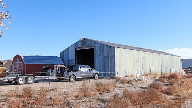
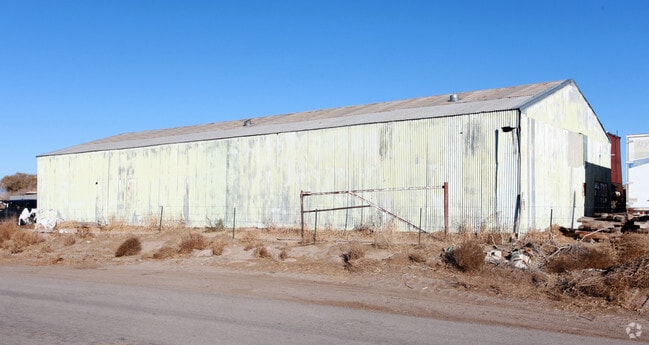
8900 Bates Rd Se
1-013-049-211178-3-02-17
Bates Lumber Comapny
Warehouse
TR B-1 CONSOLIDATION PLAT OF LAND OF BATES LUMBER COMPANY CO NT 1.41 AC
X
Bernalillo
35001C0533H
New Mexico
2024
20.29 AC
2025
South Valley
004001
Albuquerque
14,276 SF
Albuquerque, NM
DEMOGRAPHICS near 8900 Bates Rd Se
1 Mile
3 Mile
5 Mile
2024 Total Population
275
7,506
24,613
2029 Population
274
7,453
24,278
Pop Growth 2024-2029
(0.36%)
(0.71%)
(1.36%)
Average Age
43
43
40
2024 Total Households
97
2,643
8,349
HH Growth 2024-2029
(1.03%)
(0.83%)
(1.53%)
Median Household Inc
$74,999
$67,013
$55,722
Avg Household Size
2.60
2.70
2.80
2024 Avg HH Vehicles
2.00
2.00
2.00
Median Home Value
$366,666
$306,040
$225,101
Median Year Built
1984
1975
1976
Nearby Places
Map Layers
Map Styles
 Street
 Aerial
- Restaurants
- Banks
- Shops
- Fitness
- Groceries
PUBLIC TRANSPORTATION
COMMUTER RAIL
Bernalillo County-International Sunport (NMRX - Rio Metro Regional Transit District, Rail Runner Express - Rio Metro Regional Transit District)
DRIVE
WALK
Distance
Bernalillo County-International Sunport (NMRX - Rio Metro Regional Transit District, Rail Runner Express - Rio Metro Regional Transit District)
12 min
6.0 mi
Isleta Pueblo (NMRX - Rio Metro Regional Transit District, Rail Runner Express - Rio Metro Regional Transit District)
DRIVE
WALK
Distance
Isleta Pueblo (NMRX - Rio Metro Regional Transit District, Rail Runner Express - Rio Metro Regional Transit District)
12 min
6.4 mi
AIRPORT
Albuquerque International Sunport
DRIVE
WALK
Distance
Albuquerque International Sunport
26 min
9.0 mi
Freight Ports
Tulsa Port Of Catoosa
DRIVE
WALK
Distance
Tulsa Port Of Catoosa
705 min
673.0 mi
Nearby Properties
Address
Land Use
TOTAL SIZE
Lot Size
Zoning
Address
Land Use
TOTAL SIZE
Lot Size
Zoning
4,234.67 AC
Address
Land Use
TOTAL SIZE
Lot Size
Zoning
30,552 SF
10.48 AC
Address
Land Use
TOTAL SIZE
Lot Size
Zoning
224.66 AC
Address
Land Use
TOTAL SIZE
Lot Size
Zoning
77,400 SF
20 AC
Address
Land Use
TOTAL SIZE
Lot Size
Zoning
192.50 AC
Address
Land Use
TOTAL SIZE
Lot Size
Zoning
48,000 SF
16.34 AC
Address
Land Use
TOTAL SIZE
Lot Size
Zoning
72.73 AC
Address
Land Use
TOTAL SIZE
Lot Size
Zoning
217,224 SF
6.48 AC
Address
Land Use
TOTAL SIZE
Lot Size
Zoning
267.90 AC
Address
Land Use
TOTAL SIZE
Lot Size
Zoning
4,950 SF
19.36 AC
Address
Land Use
TOTAL SIZE
Lot Size
Zoning
19,070 SF
29.33 AC
Address
Land Use
TOTAL SIZE
Lot Size
Zoning
24,585 SF
14.39 AC
Address
Land Use
TOTAL SIZE
Lot Size
Zoning
53.01 AC
Address
Land Use
TOTAL SIZE
Lot Size
Zoning
11,142 SF
10.37 AC
Address
Land Use
TOTAL SIZE
Lot Size
Zoning
14,810 SF
13.66 AC
Address
Land Use
TOTAL SIZE
Lot Size
Zoning
30,424 SF
10.98 AC
Address
Land Use
TOTAL SIZE
Lot Size
Zoning
19,372 SF
4.63 AC
Address
Land Use
TOTAL SIZE
Lot Size
Zoning
Address
Land Use
TOTAL SIZE
Lot Size
Zoning
31,002 SF
7.79 AC
Address
Land Use
TOTAL SIZE
Lot Size
Zoning
27,420 SF
2.50 AC
Address
Land Use
TOTAL SIZE
Lot Size
Zoning
Address
Land Use
TOTAL SIZE
Lot Size
Zoning
11,610 SF
8.17 AC
Address
Land Use
TOTAL SIZE
Lot Size
Zoning
10,976 SF
8.85 AC
Address
Land Use
TOTAL SIZE
Lot Size
Zoning
26,642 SF
16.48 AC
Address
Land Use
TOTAL SIZE
Lot Size
Zoning
25,690 SF
61.08 AC
Address
Land Use
TOTAL SIZE
Lot Size
Zoning
2,000 SF
10.29 AC
Address
Land Use
TOTAL SIZE
Lot Size
Zoning
7,489 SF
20 AC
Address
Land Use
TOTAL SIZE
Lot Size
Zoning
8,450 SF
6.74 AC
The World's #1 Commercial Real Estate Marketplace
Connect with us
© 2026 CoStar Group
The information above has been obtained from sources believed reliable. While we do not doubt its accuracy we have not verified it and make no guarantee, warranty or representation about it. It is your responsibility to independently confirm its accuracy and completeness. Any projections, opinions, assumptions, or estimates used are for example only and do not represent the current or future performance of the property. The value of this transaction to you depends on tax and other factors which should be evaluated by your tax, financial, and legal advisors. You and your advisors should conduct a careful, independent investigation of the property to determine to your satisfaction the suitability of the property for your needs.