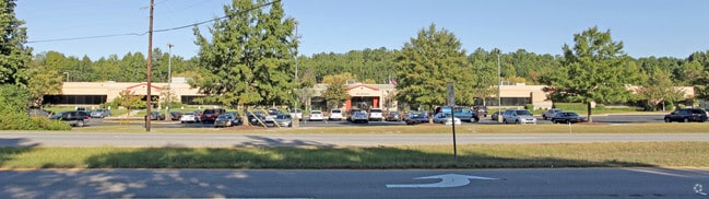
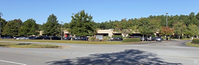
Property Record
8901 Farrow Rd, Columbia, SC 29203
NEARBY LISTINGS FOR SALE OR LEASE
Property Detail
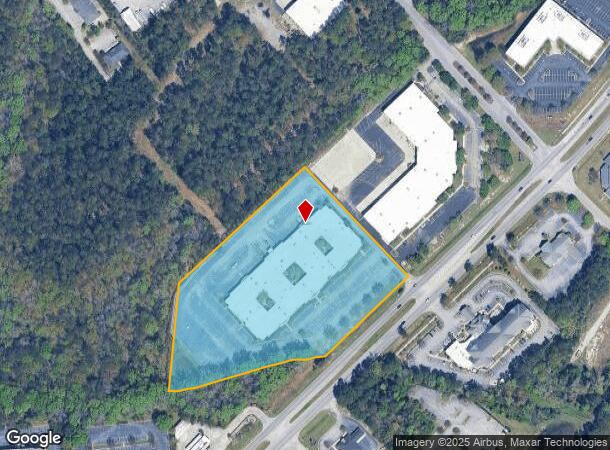
8901 Farrow Rd
17200-03-12
TRACT A & B #PR 52-3575
Commercialnec
Richland
AE
South Carolina
45079C0252L
7.33 AC
2025
Northeast Columbia
2024
Columbia
011421
Columbia, SC
79,545 SF
DEMOGRAPHICS near 8901 Farrow Rd
1 Mile
3 Mile
5 Mile
2024 Total Population
3,464
35,004
113,162
2029 Population
3,484
35,598
114,750
Pop Growth 2024-2029
+ 0.58%
+ 1.70%
+ 1.40%
Average Age
38
38
39
2024 Total Households
1,445
14,567
45,886
HH Growth 2024-2029
+ 0.55%
+ 1.73%
+ 1.47%
Median Household Inc
$57,194
$55,346
$58,564
Avg Household Size
2.30
2.30
2.40
2024 Avg HH Vehicles
2.00
2.00
2.00
Median Home Value
$160,261
$175,587
$182,161
Median Year Built
1997
1993
1992
Nearby Places
Map Layers
Map Styles
 Street
 Aerial
- Restaurants
- Banks
- Shops
- Fitness
- Groceries
PUBLIC TRANSPORTATION
AIRPORT
Columbia Metro
DRIVE
WALK
Distance
Columbia Metro
36 min
20.8 mi
Freight Ports
North Charleston Terminal
DRIVE
WALK
Distance
North Charleston Terminal
135 min
118.0 mi
Nearby Properties
Address
Land Use
TOTAL SIZE
Lot Size
Zoning
Address
Land Use
TOTAL SIZE
Lot Size
Zoning
231,760 SF
23.84 AC
M-1
Address
Land Use
TOTAL SIZE
Lot Size
Zoning
144,849 SF
26.14 AC
OI
Address
Land Use
TOTAL SIZE
Lot Size
Zoning
456,536 SF
42.16 AC
M-1
Address
Land Use
TOTAL SIZE
Lot Size
Zoning
83,808 SF
95.58 AC
PDD
Address
Land Use
TOTAL SIZE
Lot Size
Zoning
354,813 SF
20.66 AC
RM-HD
Address
Land Use
TOTAL SIZE
Lot Size
Zoning
338,744 SF
21.28 AC
RM-HD
Address
Land Use
TOTAL SIZE
Lot Size
Zoning
325,344 SF
71.41 AC
HI
Address
Land Use
TOTAL SIZE
Lot Size
Zoning
234,990 SF
16.50 AC
RM-HD
Address
Land Use
TOTAL SIZE
Lot Size
Zoning
278,001 SF
28.82 AC
GC
Address
Land Use
TOTAL SIZE
Lot Size
Zoning
306,612 SF
20.94 AC
GC
Address
Land Use
TOTAL SIZE
Lot Size
Zoning
260,572 SF
15 AC
GC
Address
Land Use
TOTAL SIZE
Lot Size
Zoning
301,627 SF
25.08 AC
PDD
Address
Land Use
TOTAL SIZE
Lot Size
Zoning
147,916 SF
4.69 AC
OI
Address
Land Use
TOTAL SIZE
Lot Size
Zoning
341,550 SF
20.66 AC
RM-HD
Address
Land Use
TOTAL SIZE
Lot Size
Zoning
239,450 SF
16.85 AC
GC
Address
Land Use
TOTAL SIZE
Lot Size
Zoning
183,237 SF
13.65 AC
GC
Address
Land Use
TOTAL SIZE
Lot Size
Zoning
147,062 SF
13.20 AC
GC
Address
Land Use
TOTAL SIZE
Lot Size
Zoning
51,803 SF
11.99 AC
M-1
Address
Land Use
TOTAL SIZE
Lot Size
Zoning
217,580 SF
32.47 AC
M-1
Address
Land Use
TOTAL SIZE
Lot Size
Zoning
242,894 SF
14.97 AC
RM-HD
Address
Land Use
TOTAL SIZE
Lot Size
Zoning
50,000 SF
18.71 AC
RS-MD
Address
Land Use
TOTAL SIZE
Lot Size
Zoning
138,552 SF
12.02 AC
RM-HD
Address
Land Use
TOTAL SIZE
Lot Size
Zoning
223,692 SF
12 AC
GC
Address
Land Use
TOTAL SIZE
Lot Size
Zoning
46,032 SF
11.11 AC
RM-HD
Address
Land Use
TOTAL SIZE
Lot Size
Zoning
148,809 SF
17.52 AC
M-1
Address
Land Use
TOTAL SIZE
Lot Size
Zoning
111,327 SF
7.96 AC
RM-HD
Address
Land Use
TOTAL SIZE
Lot Size
Zoning
129,017 SF
14.70 AC
PDD
Address
Land Use
TOTAL SIZE
Lot Size
Zoning
71,394 SF
12.05 AC
M-1
Address
Land Use
TOTAL SIZE
Lot Size
Zoning
72,938 SF
3.22 AC
M-1
Address
Land Use
TOTAL SIZE
Lot Size
Zoning
132,097 SF
10.63 AC
GC
The World's #1 Commercial Real Estate Marketplace
Connect with us
© 2026 CoStar Group
The information above has been obtained from sources believed reliable. While we do not doubt its accuracy we have not verified it and make no guarantee, warranty or representation about it. It is your responsibility to independently confirm its accuracy and completeness. Any projections, opinions, assumptions, or estimates used are for example only and do not represent the current or future performance of the property. The value of this transaction to you depends on tax and other factors which should be evaluated by your tax, financial, and legal advisors. You and your advisors should conduct a careful, independent investigation of the property to determine to your satisfaction the suitability of the property for your needs.