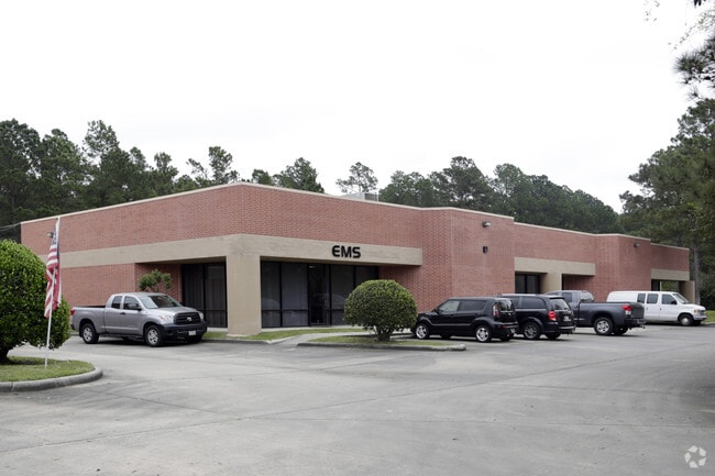
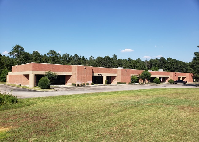
Property Record
8902 Fm 2920 Rd, Spring, TX 77379

NEARBY LISTINGS FOR SALE OR LEASE
Property Detail
8902 Fm 2920 Rd
0460450000025
Abst 945 M Yates
Warehouse
TR 1G-5 ABST 945 M YATES
X
Harris
48201C0235M
Texas
2024
0.81 AC
2025
North Fwy/Tomball Pky
554907
Houston
9,445 SF
Houston-Pasadena-The Woodlands, TX
DEMOGRAPHICS near 8902 Fm 2920 Rd
1 Mile
3 Mile
5 Mile
2024 Total Population
9,022
68,014
209,405
2029 Population
9,410
69,983
214,562
Pop Growth 2024-2029
+ 4.30%
+ 2.89%
+ 2.46%
Average Age
34
36
37
2024 Total Households
2,706
22,000
69,723
HH Growth 2024-2029
+ 4.25%
+ 2.86%
+ 2.45%
Median Household Inc
$89,675
$101,930
$100,756
Avg Household Size
3.30
3.00
2.90
2024 Avg HH Vehicles
2.00
2.00
2.00
Median Home Value
$263,900
$289,230
$283,028
Median Year Built
2008
2008
2004
Nearby Places
Map Layers
Map Styles
 Street
 Aerial
- Restaurants
- Banks
- Shops
- Fitness
- Groceries
PUBLIC TRANSPORTATION
AIRPORT
George Bush Intcntl/Houston
DRIVE
WALK
Distance
George Bush Intcntl/Houston
30 min
24.4 mi
William P Hobby
DRIVE
WALK
Distance
William P Hobby
62 min
43.8 mi
Freight Ports
Port of Houston
DRIVE
WALK
Distance
Port of Houston
53 min
40.1 mi
SALE & LEASE HISTORY
LISTING DATE
SALE/LEASE

Oct 15, 2018
For Lease
Nearby Properties
Address
Land Use
TOTAL SIZE
Lot Size
Zoning
Address
Land Use
TOTAL SIZE
Lot Size
Zoning
379,180 SF
15.52 AC
Address
Land Use
TOTAL SIZE
Lot Size
Zoning
156,885 SF
26.24 AC
Address
Land Use
TOTAL SIZE
Lot Size
Zoning
341,895 SF
17.53 AC
Address
Land Use
TOTAL SIZE
Lot Size
Zoning
398,856 SF
12.76 AC
Address
Land Use
TOTAL SIZE
Lot Size
Zoning
375,293 SF
19.29 AC
Address
Land Use
TOTAL SIZE
Lot Size
Zoning
335,258 SF
12.18 AC
Address
Land Use
TOTAL SIZE
Lot Size
Zoning
328,692 SF
18.47 AC
Address
Land Use
TOTAL SIZE
Lot Size
Zoning
322,733 SF
18.40 AC
Address
Land Use
TOTAL SIZE
Lot Size
Zoning
332,688 SF
24.57 AC
Address
Land Use
TOTAL SIZE
Lot Size
Zoning
294,931 SF
10.94 AC
Address
Land Use
TOTAL SIZE
Lot Size
Zoning
306,815 SF
14.88 AC
Address
Land Use
TOTAL SIZE
Lot Size
Zoning
249,950 SF
15.92 AC
Address
Land Use
TOTAL SIZE
Lot Size
Zoning
267,082 SF
11.13 AC
Address
Land Use
TOTAL SIZE
Lot Size
Zoning
393,751 SF
17.08 AC
Address
Land Use
TOTAL SIZE
Lot Size
Zoning
241,113 SF
6.29 AC
Address
Land Use
TOTAL SIZE
Lot Size
Zoning
207,662 SF
11.32 AC
Address
Land Use
TOTAL SIZE
Lot Size
Zoning
188,265 SF
15.65 AC
Address
Land Use
TOTAL SIZE
Lot Size
Zoning
253,800 SF
43.72 AC
Address
Land Use
TOTAL SIZE
Lot Size
Zoning
219,000 SF
46.59 AC
Address
Land Use
TOTAL SIZE
Lot Size
Zoning
800 SF
23.53 AC
Address
Land Use
TOTAL SIZE
Lot Size
Zoning
233,293 SF
13.20 AC
Address
Land Use
TOTAL SIZE
Lot Size
Zoning
155,960 SF
25.96 AC
Address
Land Use
TOTAL SIZE
Lot Size
Zoning
145,051 SF
6.10 AC
Address
Land Use
TOTAL SIZE
Lot Size
Zoning
214,862 SF
14.92 AC
Address
Land Use
TOTAL SIZE
Lot Size
Zoning
106,618 SF
12.48 AC
Address
Land Use
TOTAL SIZE
Lot Size
Zoning
224,669 SF
15.40 AC
Address
Land Use
TOTAL SIZE
Lot Size
Zoning
96,300 SF
21.59 AC
Address
Land Use
TOTAL SIZE
Lot Size
Zoning
120,220 SF
13.49 AC
Address
Land Use
TOTAL SIZE
Lot Size
Zoning
211,876 SF
21.78 AC
Address
Land Use
TOTAL SIZE
Lot Size
Zoning
202,728 SF
3.50 AC
The World's #1 Commercial Real Estate Marketplace
Connect with us
© 2026 CoStar Group
The information above has been obtained from sources believed reliable. While we do not doubt its accuracy we have not verified it and make no guarantee, warranty or representation about it. It is your responsibility to independently confirm its accuracy and completeness. Any projections, opinions, assumptions, or estimates used are for example only and do not represent the current or future performance of the property. The value of this transaction to you depends on tax and other factors which should be evaluated by your tax, financial, and legal advisors. You and your advisors should conduct a careful, independent investigation of the property to determine to your satisfaction the suitability of the property for your needs.