Property Record
8902 Zier Rd, Yakima, WA 98908
NEARBY LISTINGS FOR SALE OR LEASE
-
-
View all Yakima listings for sale on LoopNet.com
Property Detail
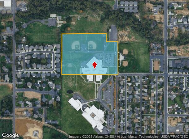
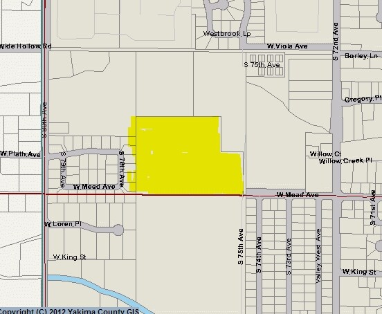
8902 Zier Rd
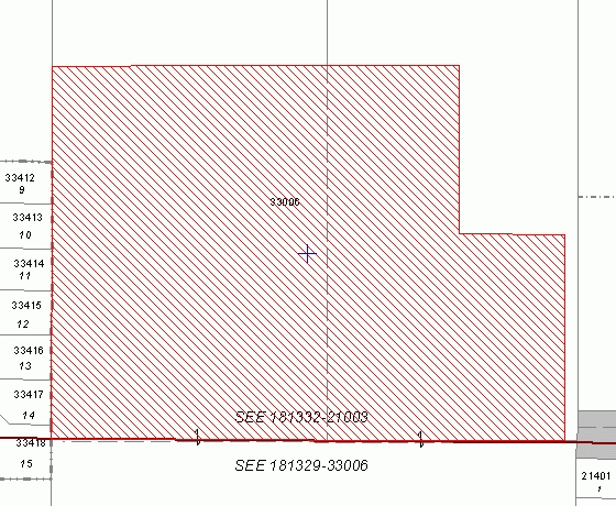
181329-33006
SECTION 29 TOWNSHIP 13 RANGE 18 QUARTER SW E 495 FT OF S 715.7 FT OF SW1/4 SW1/4, ALSO BEG SW CO SE1/4 SW1/4, TH S 89^ 38' 30 E 446.03 FT, TH N 00^ 01' 54 W 575 FT, TH N 89^ 38' 30 W 200.03 FT, TH N 00^ 01' 54 W 140.72 FT, TH N 89^ 38' 30 W 245.67 FT
Publichealthcarefacility
Yakima
AE
Washington
53077C1028F
14.96 AC
2025
Outlying Yakima County
2025
Yakima
002803
Yakima, WA
107,078 SF
DEMOGRAPHICS near 8902 Zier Rd
1 Mile
3 Mile
5 Mile
2024 Total Population
8,439
44,262
95,196
2029 Population
8,754
44,844
95,929
Pop Growth 2024-2029
+ 3.73%
+ 1.31%
+ 0.77%
Average Age
39
41
38
2024 Total Households
3,194
17,220
35,453
HH Growth 2024-2029
+ 3.57%
+ 1.18%
+ 0.76%
Median Household Inc
$71,238
$70,346
$60,913
Avg Household Size
2.60
2.50
2.60
2024 Avg HH Vehicles
2.00
2.00
2.00
Median Home Value
$281,541
$306,723
$273,059
Median Year Built
1997
1981
1974
Nearby Places
Map Layers
Map Styles
 Street
 Aerial
- Restaurants
- Banks
- Shops
- Fitness
- Groceries
PUBLIC TRANSPORTATION
AIRPORT
Yakima Air Trml/McAllister Field
DRIVE
WALK
Distance
Yakima Air Trml/McAllister Field
10 min
4.4 mi
Freight Ports
Port of Tacoma
DRIVE
WALK
Distance
Port of Tacoma
194 min
161.5 mi
Nearby Properties
Address
Land Use
TOTAL SIZE
Lot Size
Zoning
Address
Land Use
TOTAL SIZE
Lot Size
Zoning
331,736 SF
34.95 AC
R1
Address
Land Use
TOTAL SIZE
Lot Size
Zoning
275,342 SF
16.10 AC
R1
Address
Land Use
TOTAL SIZE
Lot Size
Zoning
226,069 SF
12.81 AC
C1
Address
Land Use
TOTAL SIZE
Lot Size
Zoning
205,680 SF
24.88 AC
C1
Address
Land Use
TOTAL SIZE
Lot Size
Zoning
119,023 SF
7.42 AC
R3
Address
Land Use
TOTAL SIZE
Lot Size
Zoning
69,675 SF
7.49 AC
R1
Address
Land Use
TOTAL SIZE
Lot Size
Zoning
65,606 SF
3.39 AC
R2
Address
Land Use
TOTAL SIZE
Lot Size
Zoning
114,192 SF
5.07 AC
C1
Address
Land Use
TOTAL SIZE
Lot Size
Zoning
69,675 SF
10.48 AC
R1
Address
Land Use
TOTAL SIZE
Lot Size
Zoning
132,213 SF
4 AC
R3
Address
Land Use
TOTAL SIZE
Lot Size
Zoning
130,114 SF
27.76 AC
R1
Address
Land Use
TOTAL SIZE
Lot Size
Zoning
105,756 SF
6.89 AC
R3
Address
Land Use
TOTAL SIZE
Lot Size
Zoning
118,830 SF
5.34 AC
LCC
Address
Land Use
TOTAL SIZE
Lot Size
Zoning
49,899 SF
1.22 AC
R3
Address
Land Use
TOTAL SIZE
Lot Size
Zoning
245,037 SF
36.84 AC
M1
Address
Land Use
TOTAL SIZE
Lot Size
Zoning
30,041 SF
4.12 AC
B2
Address
Land Use
TOTAL SIZE
Lot Size
Zoning
57,223 SF
2.98 AC
B1
Address
Land Use
TOTAL SIZE
Lot Size
Zoning
29,752 SF
2.17 AC
B1
Address
Land Use
TOTAL SIZE
Lot Size
Zoning
81,126 SF
3.98 AC
R3
Address
Land Use
TOTAL SIZE
Lot Size
Zoning
77,340 SF
2.04 AC
R3
Address
Land Use
TOTAL SIZE
Lot Size
Zoning
62,968 SF
14.24 AC
R1
Address
Land Use
TOTAL SIZE
Lot Size
Zoning
104,185 SF
4.42 AC
R1
Address
Land Use
TOTAL SIZE
Lot Size
Zoning
114,772 SF
9.12 AC
LCC
Address
Land Use
TOTAL SIZE
Lot Size
Zoning
80,981 SF
7 AC
LCC
Address
Land Use
TOTAL SIZE
Lot Size
Zoning
314,193 SF
19.14 AC
M1
Address
Land Use
TOTAL SIZE
Lot Size
Zoning
91,596 SF
7.72 AC
R2
Address
Land Use
TOTAL SIZE
Lot Size
Zoning
90,864 SF
5.55 AC
R2
Address
Land Use
TOTAL SIZE
Lot Size
Zoning
58,086 SF
2.78 AC
C1
Address
Land Use
TOTAL SIZE
Lot Size
Zoning
102,992 SF
5.83 AC
M1
The World's #1 Commercial Real Estate Marketplace
Connect with us
© 2026 CoStar Group
The information above has been obtained from sources believed reliable. While we do not doubt its accuracy we have not verified it and make no guarantee, warranty or representation about it. It is your responsibility to independently confirm its accuracy and completeness. Any projections, opinions, assumptions, or estimates used are for example only and do not represent the current or future performance of the property. The value of this transaction to you depends on tax and other factors which should be evaluated by your tax, financial, and legal advisors. You and your advisors should conduct a careful, independent investigation of the property to determine to your satisfaction the suitability of the property for your needs.