Property Record
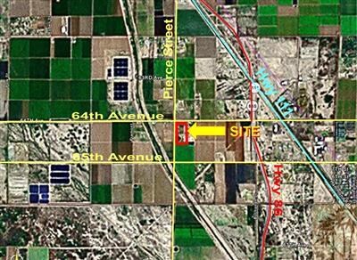
89055 64Th Ave, Thermal, CA 92274


Property Detail
89055 64Th Ave
749-070-001
18.88 ACRES IN POR NW 1/4 OF SEC 12 T7S R8E FOR TOTAL DESCRIPTION SEE ASSESSORS MAPS
Horticulturegrowinghousesagricultural
Riverside
A110
California
AE The base floodplain where base flood elevations are provided. AE Zones are now used on new format FIRMs instead of A1-A30 Zones.
18.88 AC
2024
Coachella Valley
2025
Inland Empire (California)
045618
Riverside-San Bernardino-Ontario, CA
3,850 SF
NEARBY LISTINGS FOR SALE OR LEASE
DEMOGRAPHICS near 89055 64Th Ave
1 mile
3 mile
5 mile
2025 Total Population
177
8,061
15,061
2030 Population
175
7,948
15,076
Pop Growth 2025-2030
(1.13%)
(1.40%)
+ 0.10%
Average Age
31
32
32
2025 Total Households
40
1,838
3,423
HH Growth 2025-2030
(2.50%)
(2.23%)
(0.53%)
Median Household Inc
$26,666
$40,489
$37,635
Avg Household Size
3.90
4.10
4.10
2025 Avg HH Vehicles
1.00
2.00
2.00
Median Home Value
$59,999
$203,110
$98,558
Median Year Built
1991
1993
1991
Nearby Places
Map Layers
Map Styles
 Street
 Aerial
Transit
 Traffic
 Biking
Places
Listings with unknown addresses are not visible on the map
- Restaurants
- Banks
- Shops
- Fitness
- Groceries
PUBLIC TRANSPORTATION
AIRPORT
Palm Springs International
Drive
Walk
Distance
Palm Springs International
43 min
34.3 mi
Freight Ports
Port of San Diego
Drive
Walk
Distance
Port of San Diego
188 min
158.4 mi
Nearby Properties
Address
Land Use
TOTAL SIZE
Lot Size
Zoning
Address
Land Use
TOTAL SIZE
Lot Size
Zoning
58,750 SF
139.26 AC
Address
Land Use
TOTAL SIZE
Lot Size
Zoning
36,123 SF
108.59 AC
A220
Address
Land Use
TOTAL SIZE
Lot Size
Zoning
5.11 AC
Address
Land Use
TOTAL SIZE
Lot Size
Zoning
6.64 AC
Address
Land Use
TOTAL SIZE
Lot Size
Zoning
5.20 AC
R3
Address
Land Use
TOTAL SIZE
Lot Size
Zoning
72,900 SF
13.58 AC
MM
Address
Land Use
TOTAL SIZE
Lot Size
Zoning
40,303 SF
3.49 AC
R3
Address
Land Use
TOTAL SIZE
Lot Size
Zoning
14,119 SF
0.34 AC
Address
Land Use
TOTAL SIZE
Lot Size
Zoning
13,152 SF
3.99 AC
R3
Address
Land Use
TOTAL SIZE
Lot Size
Zoning
22.81 AC
A15
Address
Land Use
TOTAL SIZE
Lot Size
Zoning
2.93 AC
R3
Address
Land Use
TOTAL SIZE
Lot Size
Zoning
19,273 SF
5.40 AC
Address
Land Use
TOTAL SIZE
Lot Size
Zoning
156.20 AC
A210
Address
Land Use
TOTAL SIZE
Lot Size
Zoning
463.45 AC
W2
Address
Land Use
TOTAL SIZE
Lot Size
Zoning
54,796 SF
3.97 AC
R3
Address
Land Use
TOTAL SIZE
Lot Size
Zoning
3.97 AC
R1
Address
Land Use
TOTAL SIZE
Lot Size
Zoning
2.63 AC
R2
Address
Land Use
TOTAL SIZE
Lot Size
Zoning
4.33 AC
R3
Address
Land Use
TOTAL SIZE
Lot Size
Zoning
61,645 SF
3.97 AC
R3
Address
Land Use
TOTAL SIZE
Lot Size
Zoning
5,436 SF
0.17 AC
Address
Land Use
TOTAL SIZE
Lot Size
Zoning
75 AC
A210
Address
Land Use
TOTAL SIZE
Lot Size
Zoning
8,389 SF
0.59 AC
CPS
Address
Land Use
TOTAL SIZE
Lot Size
Zoning
8,690 SF
0.17 AC
Address
Land Use
TOTAL SIZE
Lot Size
Zoning
81 AC
A210
Address
Land Use
TOTAL SIZE
Lot Size
Zoning
19,744 SF
0.84 AC
Address
Land Use
TOTAL SIZE
Lot Size
Zoning
4,504 SF
1.08 AC
The World's #1 Commercial Real Estate Marketplace
Connect with us
© 2026 CoStar Group
The information above has been obtained from sources believed reliable. While we do not doubt its accuracy we have not verified it and make no guarantee, warranty or representation about it. It is your responsibility to independently confirm its accuracy and completeness. Any projections, opinions, assumptions, or estimates used are for example only and do not represent the current or future performance of the property. The value of this transaction to you depends on tax and other factors which should be evaluated by your tax, financial, and legal advisors. You and your advisors should conduct a careful, independent investigation of the property to determine to your satisfaction the suitability of the property for your needs.