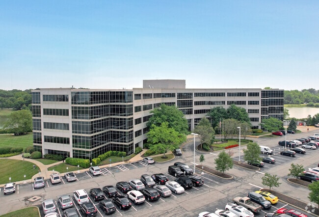
Property Record
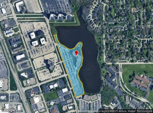
8909 Purdue Rd, Indianapolis, IN 46268


NEARBY LISTINGS FOR SALE OR LEASE
Property Detail
8909 Purdue Rd
49-03-17-102-034.000-600
College Park West Add
Officebuilding
COLLEGE PARK WEST ADD BLK 22 & PT BLK 251 BEG NW COR BLK 22 P.O.B. E71.57 SEIRR508.01 NEIRR318.36 SIRR910.45 SE65.01 SE88.46 SE258.12 SW219.59 NW1568.65 TO BEG
AE
Marion
18097C0036F
Indiana
2023
10.23 AC
2024
College Park
310104
Indianapolis
283 SF
Indianapolis-Carmel-Anderson, IN
DEMOGRAPHICS near 8909 Purdue Rd
1 Mile
3 Mile
5 Mile
2024 Total Population
6,990
53,616
143,894
2029 Population
6,913
54,240
148,177
Pop Growth 2024-2029
(1.10%)
+ 1.16%
+ 2.98%
Average Age
42
39
40
2024 Total Households
3,800
23,160
59,265
HH Growth 2024-2029
(1.61%)
+ 0.67%
+ 2.50%
Median Household Inc
$63,521
$69,020
$82,428
Avg Household Size
1.80
2.20
2.40
2024 Avg HH Vehicles
1.00
2.00
2.00
Median Home Value
$192,653
$260,859
$311,021
Median Year Built
1983
1984
1985
Nearby Places
Map Layers
Map Styles
 Street
 Aerial
- Restaurants
- Banks
- Shops
- Fitness
- Groceries
PUBLIC TRANSPORTATION
AIRPORT
Indianapolis International
DRIVE
WALK
Distance
Indianapolis International
41 min
23.8 mi
Freight Ports
Port of Toledo
DRIVE
WALK
Distance
Port of Toledo
268 min
225.0 mi
Nearby Properties
Address
Land Use
TOTAL SIZE
Lot Size
Zoning
Address
Land Use
TOTAL SIZE
Lot Size
Zoning
303,520 SF
39.62 AC
ZO01
Address
Land Use
TOTAL SIZE
Lot Size
Zoning
476,078 SF
8.08 AC
ZO01
Address
Land Use
TOTAL SIZE
Lot Size
Zoning
278,637 SF
43.98 AC
ZO01
Address
Land Use
TOTAL SIZE
Lot Size
Zoning
1,470 SF
19.02 AC
ZO01
Address
Land Use
TOTAL SIZE
Lot Size
Zoning
18,569 SF
9.57 AC
ZO01
Address
Land Use
TOTAL SIZE
Lot Size
Zoning
34,863 SF
14.77 AC
ZO01
Address
Land Use
TOTAL SIZE
Lot Size
Zoning
5,434 SF
11.35 AC
ZO01
Address
Land Use
TOTAL SIZE
Lot Size
Zoning
2,544 SF
37.75 AC
ZO01
Address
Land Use
TOTAL SIZE
Lot Size
Zoning
10,380 SF
24 AC
ZO01
Address
Land Use
TOTAL SIZE
Lot Size
Zoning
4,267 SF
21.06 AC
ZO01
Address
Land Use
TOTAL SIZE
Lot Size
Zoning
168,710 SF
5.24 AC
ZO01
Address
Land Use
TOTAL SIZE
Lot Size
Zoning
68,990 SF
188.21 AC
ZO01
Address
Land Use
TOTAL SIZE
Lot Size
Zoning
1,904 SF
45.69 AC
ZO01
Address
Land Use
TOTAL SIZE
Lot Size
Zoning
9,076 SF
18 AC
ZO01
Address
Land Use
TOTAL SIZE
Lot Size
Zoning
301,907 SF
43.90 AC
ZO01
Address
Land Use
TOTAL SIZE
Lot Size
Zoning
521,092 SF
23.46 AC
ZO01
Address
Land Use
TOTAL SIZE
Lot Size
Zoning
89,245 SF
45.14 AC
ZO01
Address
Land Use
TOTAL SIZE
Lot Size
Zoning
359,121 SF
0.06 AC
ZO01
Address
Land Use
TOTAL SIZE
Lot Size
Zoning
512,730 SF
21.80 AC
ZO01
Address
Land Use
TOTAL SIZE
Lot Size
Zoning
111,601 SF
5.74 AC
ZO01
Address
Land Use
TOTAL SIZE
Lot Size
Zoning
742,342 SF
27.69 AC
ZO01
Address
Land Use
TOTAL SIZE
Lot Size
Zoning
12,023 SF
48.47 AC
ZO01
Address
Land Use
TOTAL SIZE
Lot Size
Zoning
115,522 SF
10.38 AC
ZO01
Address
Land Use
TOTAL SIZE
Lot Size
Zoning
18,768 SF
45.36 AC
ZO01
Address
Land Use
TOTAL SIZE
Lot Size
Zoning
2,103 SF
11.67 AC
ZO01
Address
Land Use
TOTAL SIZE
Lot Size
Zoning
110,373 SF
47.98 AC
ZO01
Address
Land Use
TOTAL SIZE
Lot Size
Zoning
149,334 SF
15.89 AC
ZO01
Address
Land Use
TOTAL SIZE
Lot Size
Zoning
3,829 SF
24.98 AC
ZO01
Address
Land Use
TOTAL SIZE
Lot Size
Zoning
6,306 SF
33.65 AC
ZO01
The World's #1 Commercial Real Estate Marketplace
Connect with us
© 2025 CoStar Group
The information above has been obtained from sources believed reliable. While we do not doubt its accuracy we have not verified it and make no guarantee, warranty or representation about it. It is your responsibility to independently confirm its accuracy and completeness. Any projections, opinions, assumptions, or estimates used are for example only and do not represent the current or future performance of the property. The value of this transaction to you depends on tax and other factors which should be evaluated by your tax, financial, and legal advisors. You and your advisors should conduct a careful, independent investigation of the property to determine to your satisfaction the suitability of the property for your needs.