Property Record
891 Baltimore Pike, Springfield, PA 19064
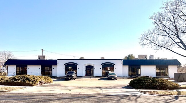

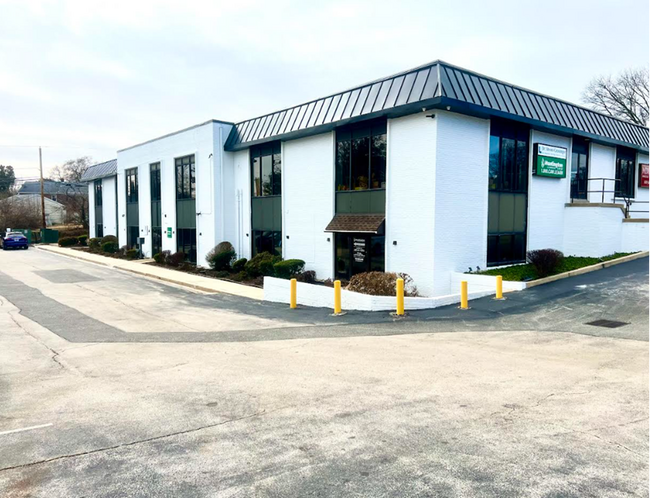

This Property Is For Sale
Property Detail
891 Baltimore Pike
42-00-00404-01
2 STY OFFICE BLDG 68 X 248 (WISE)
Officebuilding
Delaware
B and X Area of moderate flood hazard, usually the area between the limits of the 100-year and 500-year floods.
Pennsylvania
2026
0.39 AC
2026
Delaware County
407806
Philadelphia
19,032 SF
Philadelphia-Camden-Wilmington, PA-NJ-DE-MD
NEARBY LISTINGS FOR SALE OR LEASE
DEMOGRAPHICS near 891 Baltimore Pike
1 mile
3 mile
5 mile
2025 Total Population
14,501
147,536
382,551
2030 Population
14,704
149,021
386,806
Pop Growth 2025-2030
+ 1.40%
+ 1.01%
+ 1.11%
Average Age
41
41
40
2025 Total Households
5,350
57,397
145,311
HH Growth 2025-2030
+ 1.59%
+ 1.05%
+ 1.17%
Median Household Inc
$115,872
$92,981
$79,385
Avg Household Size
2.60
2.50
2.50
2025 Avg HH Vehicles
2.00
2.00
2.00
Median Home Value
$379,659
$304,768
$282,990
Median Year Built
1955
1954
1954
Nearby Places
Map Layers
Map Styles
 Street
 Aerial
Layers
 Traffic
 Biking
Places
Listings with unknown addresses are not visible on the map
- Restaurants
- Banks
- Shops
- Fitness
- Groceries
PUBLIC TRANSPORTATION
TRANSIT/SUBWAY
Thomson Av (Route 101 - SEPTA)
Drive
Walk
Distance
Thomson Av (Route 101 - SEPTA)
2 min
13 min
0.7 mi
Woodland Av (Route 101 - SEPTA)
Drive
Walk
Distance
Woodland Av (Route 101 - SEPTA)
2 min
17 min
0.9 mi
Springfield Mall (Route 101 - SEPTA)
Drive
Walk
Distance
Springfield Mall (Route 101 - SEPTA)
3 min
18 min
1.0 mi
COMMUTER RAIL
Morton (R3 - Southeastern Pennsylvania Transportation Authority Regional Rail (SEPTA Regional Rail))
Drive
Walk
Distance
Morton (R3 - Southeastern Pennsylvania Transportation Authority Regional Rail (SEPTA Regional Rail))
2 min
17 min
0.9 mi
Swarthmore (R3 - Southeastern Pennsylvania Transportation Authority Regional Rail (SEPTA Regional Rail))
Drive
Walk
Distance
Swarthmore (R3 - Southeastern Pennsylvania Transportation Authority Regional Rail (SEPTA Regional Rail))
4 min
1.6 mi
AIRPORT
Philadelphia International
Drive
Walk
Distance
Philadelphia International
16 min
7.6 mi
Freight Ports
South Jersey Port
Drive
Walk
Distance
South Jersey Port
34 min
20.0 mi
Nearby Properties
Address
Land Use
TOTAL SIZE
Lot Size
Zoning
Address
Land Use
TOTAL SIZE
Lot Size
Zoning
6,637 SF
198.92 AC
Address
Land Use
TOTAL SIZE
Lot Size
Zoning
15,660 SF
56.60 AC
Address
Land Use
TOTAL SIZE
Lot Size
Zoning
280,591 SF
2.76 AC
Address
Land Use
TOTAL SIZE
Lot Size
Zoning
48,739 SF
30 AC
Address
Land Use
TOTAL SIZE
Lot Size
Zoning
702,532 SF
11 AC
Address
Land Use
TOTAL SIZE
Lot Size
Zoning
20,880 SF
27.20 AC
Address
Land Use
TOTAL SIZE
Lot Size
Zoning
6,040 SF
16.45 AC
Address
Land Use
TOTAL SIZE
Lot Size
Zoning
241,578 SF
14 AC
Address
Land Use
TOTAL SIZE
Lot Size
Zoning
136,972 SF
27 AC
Address
Land Use
TOTAL SIZE
Lot Size
Zoning
312,988 SF
24 AC
Address
Land Use
TOTAL SIZE
Lot Size
Zoning
255,316 SF
6 AC
Address
Land Use
TOTAL SIZE
Lot Size
Zoning
61,860 SF
6.29 AC
Address
Land Use
TOTAL SIZE
Lot Size
Zoning
2,608 SF
198.92 AC
Address
Land Use
TOTAL SIZE
Lot Size
Zoning
2,562 SF
198.92 AC
Address
Land Use
TOTAL SIZE
Lot Size
Zoning
170,442 SF
26.04 AC
Address
Land Use
TOTAL SIZE
Lot Size
Zoning
215,557 SF
22 AC
Address
Land Use
TOTAL SIZE
Lot Size
Zoning
261,618 SF
30.57 AC
Address
Land Use
TOTAL SIZE
Lot Size
Zoning
76,600 SF
16.90 AC
Address
Land Use
TOTAL SIZE
Lot Size
Zoning
282,520 SF
24.44 AC
Address
Land Use
TOTAL SIZE
Lot Size
Zoning
187,056 SF
16 AC
Address
Land Use
TOTAL SIZE
Lot Size
Zoning
164,834 SF
13 AC
Address
Land Use
TOTAL SIZE
Lot Size
Zoning
60,588 SF
9.43 AC
Address
Land Use
TOTAL SIZE
Lot Size
Zoning
110,424 SF
5.32 AC
Address
Land Use
TOTAL SIZE
Lot Size
Zoning
122,018 SF
16.24 AC
Address
Land Use
TOTAL SIZE
Lot Size
Zoning
90,368 SF
124 AC
Address
Land Use
TOTAL SIZE
Lot Size
Zoning
12,100 SF
7 AC
Address
Land Use
TOTAL SIZE
Lot Size
Zoning
150,450 SF
9 AC
Address
Land Use
TOTAL SIZE
Lot Size
Zoning
51,280 SF
7 AC
Address
Land Use
TOTAL SIZE
Lot Size
Zoning
152,403 SF
16.98 AC
Address
Land Use
TOTAL SIZE
Lot Size
Zoning
13,200 SF
7 AC
The World's #1 Commercial Real Estate Marketplace
Connect with us
© 2026 CoStar Group
The information above has been obtained from sources believed reliable. While we do not doubt its accuracy we have not verified it and make no guarantee, warranty or representation about it. It is your responsibility to independently confirm its accuracy and completeness. Any projections, opinions, assumptions, or estimates used are for example only and do not represent the current or future performance of the property. The value of this transaction to you depends on tax and other factors which should be evaluated by your tax, financial, and legal advisors. You and your advisors should conduct a careful, independent investigation of the property to determine to your satisfaction the suitability of the property for your needs.