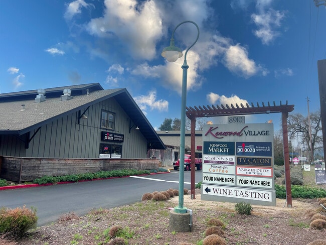
Property Record
8910 Sonoma Hwy, Kenwood, CA 95452


Current Lease Availabilities
NEARBY LISTINGS FOR SALE OR LEASE
-
-
View all Kenwood listings for lease on LoopNet.com
Property Detail
8910 Sonoma Hwy
050-162-031
Los Guillicos
Regionalshoppingcenterormallwithanchorstore
73 FORM 50-160-54 AP CHG MD
X
Sonoma
06097C0766E
California
2024
2.32 AC
2025
Sonoma/Wine Country
150501
North Bay/Santa Rosa
16,128 SF
Santa Rosa, CA
DEMOGRAPHICS near 8910 Sonoma Hwy
1 Mile
3 Mile
5 Mile
2024 Total Population
693
5,189
8,988
2029 Population
645
5,067
8,765
Pop Growth 2024-2029
(6.93%)
(2.35%)
(2.48%)
Average Age
55
66
63
2024 Total Households
321
2,946
4,917
HH Growth 2024-2029
(7.17%)
(2.17%)
(2.32%)
Median Household Inc
$107,031
$102,196
$107,675
Avg Household Size
2.10
1.80
1.80
2024 Avg HH Vehicles
2.00
2.00
2.00
Median Home Value
$896,341
$862,042
$889,457
Median Year Built
1969
1976
1976
Nearby Places
Map Layers
Map Styles
 Street
 Aerial
- Restaurants
- Banks
- Shops
- Fitness
- Groceries
PUBLIC TRANSPORTATION
AIRPORT
Charles M Schulz - Sonoma County
DRIVE
WALK
Distance
Charles M Schulz - Sonoma County
29 min
18.3 mi
Freight Ports
Port of Richmond
DRIVE
WALK
Distance
Port of Richmond
72 min
49.3 mi
Nearby Properties
Address
Land Use
TOTAL SIZE
Lot Size
Zoning
Address
Land Use
TOTAL SIZE
Lot Size
Zoning
168,624 SF
80.57 AC
Address
Land Use
TOTAL SIZE
Lot Size
Zoning
4,628 SF
248.96 AC
LIA100
Address
Land Use
TOTAL SIZE
Lot Size
Zoning
10,292 SF
32.85 AC
DA20
Address
Land Use
TOTAL SIZE
Lot Size
Zoning
27,573 SF
2.54 AC
AIB6
Address
Land Use
TOTAL SIZE
Lot Size
Zoning
8,306 SF
12.69 AC
DA20
Address
Land Use
TOTAL SIZE
Lot Size
Zoning
51.90 AC
Address
Land Use
TOTAL SIZE
Lot Size
Zoning
17,639 SF
25.91 AC
Address
Land Use
TOTAL SIZE
Lot Size
Zoning
44.75 AC
Address
Land Use
TOTAL SIZE
Lot Size
Zoning
6,944 SF
8.92 AC
LIA100
Address
Land Use
TOTAL SIZE
Lot Size
Zoning
23.17 AC
Address
Land Use
TOTAL SIZE
Lot Size
Zoning
672 SF
37.80 AC
LIA20
Address
Land Use
TOTAL SIZE
Lot Size
Zoning
8,312 SF
10.17 AC
DA20
Address
Land Use
TOTAL SIZE
Lot Size
Zoning
13,207 SF
93.07 AC
LIA60
Address
Land Use
TOTAL SIZE
Lot Size
Zoning
6,922 SF
4 AC
Address
Land Use
TOTAL SIZE
Lot Size
Zoning
6,871 SF
2.02 AC
DA20
Address
Land Use
TOTAL SIZE
Lot Size
Zoning
5,914 SF
5.02 AC
Address
Land Use
TOTAL SIZE
Lot Size
Zoning
12,512 SF
39.50 AC
Address
Land Use
TOTAL SIZE
Lot Size
Zoning
12,809 SF
5.15 AC
Address
Land Use
TOTAL SIZE
Lot Size
Zoning
6,937 SF
10.38 AC
DA20
Address
Land Use
TOTAL SIZE
Lot Size
Zoning
8,812 SF
73.84 AC
Address
Land Use
TOTAL SIZE
Lot Size
Zoning
18,366 SF
23.40 AC
Address
Land Use
TOTAL SIZE
Lot Size
Zoning
14,519 SF
10.64 AC
Address
Land Use
TOTAL SIZE
Lot Size
Zoning
11,464 SF
5 AC
DA10
Address
Land Use
TOTAL SIZE
Lot Size
Zoning
892 SF
10 AC
DA20
Address
Land Use
TOTAL SIZE
Lot Size
Zoning
8,652 SF
96.86 AC
Address
Land Use
TOTAL SIZE
Lot Size
Zoning
22,531 SF
354.36 AC
Address
Land Use
TOTAL SIZE
Lot Size
Zoning
3,490 SF
40.01 AC
Address
Land Use
TOTAL SIZE
Lot Size
Zoning
6,398 SF
10.36 AC
Address
Land Use
TOTAL SIZE
Lot Size
Zoning
4,782 SF
22.15 AC
DA20
Address
Land Use
TOTAL SIZE
Lot Size
Zoning
5,221 SF
6.14 AC
The World's #1 Commercial Real Estate Marketplace
Connect with us
© 2026 CoStar Group
The information above has been obtained from sources believed reliable. While we do not doubt its accuracy we have not verified it and make no guarantee, warranty or representation about it. It is your responsibility to independently confirm its accuracy and completeness. Any projections, opinions, assumptions, or estimates used are for example only and do not represent the current or future performance of the property. The value of this transaction to you depends on tax and other factors which should be evaluated by your tax, financial, and legal advisors. You and your advisors should conduct a careful, independent investigation of the property to determine to your satisfaction the suitability of the property for your needs.