Property Record
89100 Avenue 62 Ave, Thermal, CA 92274


NEARBY LISTINGS FOR SALE OR LEASE
Property Detail
89100 Avenue 62 Ave
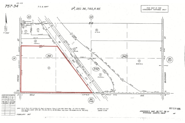
757-341-004
80.87 ACRES IN POR S 1/2 OF SEC 36 T6S R8E FOR TOTAL DESCRIPTION SEE ASSESSORS MAPS
Farms
Riverside
AE
California
06065C2930H
80.87 AC
2024
Coachella Valley
2025
Inland Empire (California)
045618
Riverside-San Bernardino-Ontario, CA
DEMOGRAPHICS near 89100 Avenue 62 Ave
1 Mile
3 Mile
5 Mile
2024 Total Population
294
6,285
14,747
2029 Population
299
6,411
15,133
Pop Growth 2024-2029
+ 1.70%
+ 2.00%
+ 2.62%
Average Age
31
32
31
2024 Total Households
66
1,485
3,350
HH Growth 2024-2029
+ 1.52%
+ 1.35%
+ 2.03%
Median Household Inc
$19,404
$27,053
$25,243
Avg Household Size
4.00
4.00
4.10
2024 Avg HH Vehicles
1.00
2.00
2.00
Median Home Value
$74,999
$118,871
$107,567
Median Year Built
1990
1989
1990
Nearby Places
Map Layers
Map Styles
 Street
 Aerial
- Restaurants
- Banks
- Shops
- Fitness
- Groceries
PUBLIC TRANSPORTATION
AIRPORT
Palm Springs International
DRIVE
WALK
Distance
Palm Springs International
40 min
33.0 mi
Freight Ports
Port of San Diego
DRIVE
WALK
Distance
Port of San Diego
186 min
157.1 mi
SALE & LEASE HISTORY
LISTING DATE
SALE/LEASE

Jun 01, 2018
For Sale
Nearby Properties
Address
Land Use
TOTAL SIZE
Lot Size
Zoning
Address
Land Use
TOTAL SIZE
Lot Size
Zoning
58,750 SF
139.26 AC
Address
Land Use
TOTAL SIZE
Lot Size
Zoning
36,123 SF
108.59 AC
A220
Address
Land Use
TOTAL SIZE
Lot Size
Zoning
5.11 AC
Address
Land Use
TOTAL SIZE
Lot Size
Zoning
6.64 AC
Address
Land Use
TOTAL SIZE
Lot Size
Zoning
72,900 SF
13.58 AC
MM
Address
Land Use
TOTAL SIZE
Lot Size
Zoning
40,303 SF
3.49 AC
R3
Address
Land Use
TOTAL SIZE
Lot Size
Zoning
30,924 SF
0.85 AC
Address
Land Use
TOTAL SIZE
Lot Size
Zoning
14,119 SF
0.34 AC
Address
Land Use
TOTAL SIZE
Lot Size
Zoning
13,152 SF
3.99 AC
R3
Address
Land Use
TOTAL SIZE
Lot Size
Zoning
15,762 SF
0.58 AC
Address
Land Use
TOTAL SIZE
Lot Size
Zoning
22.81 AC
A15
Address
Land Use
TOTAL SIZE
Lot Size
Zoning
2.93 AC
R3
Address
Land Use
TOTAL SIZE
Lot Size
Zoning
156.20 AC
A210
Address
Land Use
TOTAL SIZE
Lot Size
Zoning
463.45 AC
W2
Address
Land Use
TOTAL SIZE
Lot Size
Zoning
57,089 SF
5.12 AC
MH
Address
Land Use
TOTAL SIZE
Lot Size
Zoning
33,720 SF
4.20 AC
MH
Address
Land Use
TOTAL SIZE
Lot Size
Zoning
2.63 AC
R2
Address
Land Use
TOTAL SIZE
Lot Size
Zoning
4.33 AC
R3
Address
Land Use
TOTAL SIZE
Lot Size
Zoning
2,250 SF
112.73 AC
A220
Address
Land Use
TOTAL SIZE
Lot Size
Zoning
5,436 SF
0.17 AC
Address
Land Use
TOTAL SIZE
Lot Size
Zoning
75 AC
A210
Address
Land Use
TOTAL SIZE
Lot Size
Zoning
8,389 SF
0.59 AC
CPS
Address
Land Use
TOTAL SIZE
Lot Size
Zoning
76.91 AC
MIX
Address
Land Use
TOTAL SIZE
Lot Size
Zoning
8,690 SF
0.17 AC
The World's #1 Commercial Real Estate Marketplace
Connect with us
© 2025 CoStar Group
The information above has been obtained from sources believed reliable. While we do not doubt its accuracy we have not verified it and make no guarantee, warranty or representation about it. It is your responsibility to independently confirm its accuracy and completeness. Any projections, opinions, assumptions, or estimates used are for example only and do not represent the current or future performance of the property. The value of this transaction to you depends on tax and other factors which should be evaluated by your tax, financial, and legal advisors. You and your advisors should conduct a careful, independent investigation of the property to determine to your satisfaction the suitability of the property for your needs.