Property Record
8915 Northend Ave, Ferndale, MI 48220

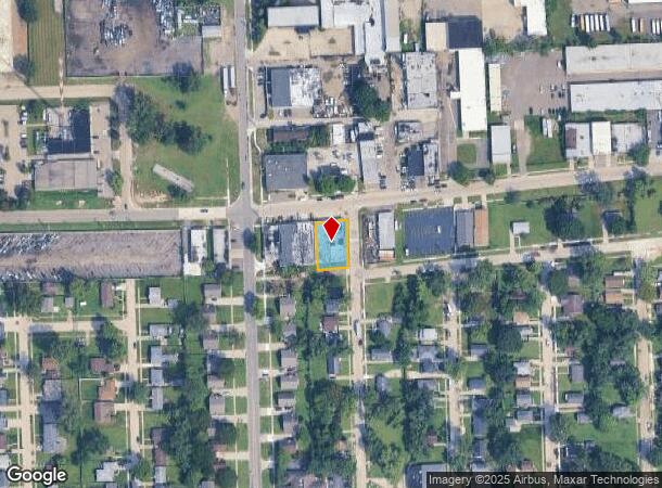
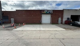
This Property Is For Sale
Current Lease Availabilities
NEARBY LISTINGS FOR SALE OR LEASE
Property Detail
8915 Northend Ave
Detroit-Warren-Dearborn, MI
Forest Grove Sub
25-33-301-003
T1N, R11E, SEC 33 FOREST GROVE SUB NO 3 LOTS 474 & 475
Warehouse
Oakland
X
Michigan
26163C0100E
474-475
2024
0.24 AC
2024
Royal Oak
172500
Detroit
8,801 SF
DEMOGRAPHICS near 8915 Northend Ave
1 Mile
3 Mile
5 Mile
2024 Total Population
14,473
153,766
400,602
2029 Population
14,267
151,141
396,757
Pop Growth 2024-2029
(1.42%)
(1.71%)
(0.96%)
Average Age
39
40
40
2024 Total Households
6,298
67,179
170,801
HH Growth 2024-2029
(1.46%)
(1.60%)
(0.92%)
Median Household Inc
$52,107
$60,754
$54,299
Avg Household Size
2.30
2.20
2.30
2024 Avg HH Vehicles
1.00
1.00
1.00
Median Home Value
$159,555
$181,665
$159,893
Median Year Built
1952
1952
1952
Nearby Places
- Restaurants
- Banks
- Shops
- Fitness
- Groceries
PUBLIC TRANSPORTATION
COMMUTER RAIL
DRIVE
WALK
Distance
10 min
3.5 mi
DRIVE
WALK
Distance
19 min
8.4 mi
AIRPORT
Windsor International
DRIVE
WALK
Distance
Windsor International
43 min
22.3 mi
Detroit Metro Wayne County
DRIVE
WALK
Distance
Detroit Metro Wayne County
43 min
26.5 mi
Nearby Properties
Address
Land Use
TOTAL SIZE
Lot Size
Zoning
Address
Land Use
TOTAL SIZE
Lot Size
Zoning
925,367 SF
12.82 AC
R6
Address
Land Use
TOTAL SIZE
Lot Size
Zoning
3,529,575 SF
84.46 AC
B4
Address
Land Use
TOTAL SIZE
Lot Size
Zoning
4.20 AC
REG BUS
Address
Land Use
TOTAL SIZE
Lot Size
Zoning
0.81 AC
CBD
Address
Land Use
TOTAL SIZE
Lot Size
Zoning
10,734 SF
3.52 AC
SPEC REDEV
Address
Land Use
TOTAL SIZE
Lot Size
Zoning
187,801 SF
5.49 AC
RM-2
Address
Land Use
TOTAL SIZE
Lot Size
Zoning
300,830 SF
54 AC
LI
Address
Land Use
TOTAL SIZE
Lot Size
Zoning
120,093 SF
38.18 AC
TV-R
Address
Land Use
TOTAL SIZE
Lot Size
Zoning
804 SF
1.50 AC
CBD
Address
Land Use
TOTAL SIZE
Lot Size
Zoning
1.46 AC
CBD
Address
Land Use
TOTAL SIZE
Lot Size
Zoning
339,780 SF
22.29 AC
RM-1
Address
Land Use
TOTAL SIZE
Lot Size
Zoning
150,703 SF
Address
Land Use
TOTAL SIZE
Lot Size
Zoning
417,880 SF
6.76 AC
RM-2
Address
Land Use
TOTAL SIZE
Lot Size
Zoning
171,259 SF
1.26 AC
CBD
Address
Land Use
TOTAL SIZE
Lot Size
Zoning
290,448 SF
9.01 AC
O
Address
Land Use
TOTAL SIZE
Lot Size
Zoning
199,592 SF
17.02 AC
B3
Address
Land Use
TOTAL SIZE
Lot Size
Zoning
273,000 SF
17.31 AC
LI
Address
Land Use
TOTAL SIZE
Lot Size
Zoning
128,309 SF
1.74 AC
Address
Land Use
TOTAL SIZE
Lot Size
Zoning
0.61 AC
CBD
Address
Land Use
TOTAL SIZE
Lot Size
Zoning
10.32 AC
LI
Address
Land Use
TOTAL SIZE
Lot Size
Zoning
1.07 AC
MIX USE 2
Address
Land Use
TOTAL SIZE
Lot Size
Zoning
133,544 SF
19.65 AC
ERO
Address
Land Use
TOTAL SIZE
Lot Size
Zoning
46,894 SF
0.52 AC
CBD
Address
Land Use
TOTAL SIZE
Lot Size
Zoning
43,437 SF
3.30 AC
REG BUS
Address
Land Use
TOTAL SIZE
Lot Size
Zoning
290,448 SF
8.92 AC
O
Address
Land Use
TOTAL SIZE
Lot Size
Zoning
137,583 SF
2.96 AC
BI
Address
Land Use
TOTAL SIZE
Lot Size
Zoning
216 SF
13.14 AC
RM
Address
Land Use
TOTAL SIZE
Lot Size
Zoning
73,701 SF
1.61 AC
PUD
Address
Land Use
TOTAL SIZE
Lot Size
Zoning
240,520 SF
8.14 AC
B-3
Address
Land Use
TOTAL SIZE
Lot Size
Zoning
165,829 SF
5.56 AC
R5
The World's #1 Commercial Real Estate Marketplace
Connect with us
© 2025 CoStar Group
The information above has been obtained from sources believed reliable. While we do not doubt its accuracy we have not verified it and make no guarantee, warranty or representation about it. It is your responsibility to independently confirm its accuracy and completeness. Any projections, opinions, assumptions, or estimates used are for example only and do not represent the current or future performance of the property. The value of this transaction to you depends on tax and other factors which should be evaluated by your tax, financial, and legal advisors. You and your advisors should conduct a careful, independent investigation of the property to determine to your satisfaction the suitability of the property for your needs.