Property Record
8915 Maislin Dr, Tampa, FL 33637
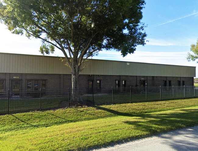

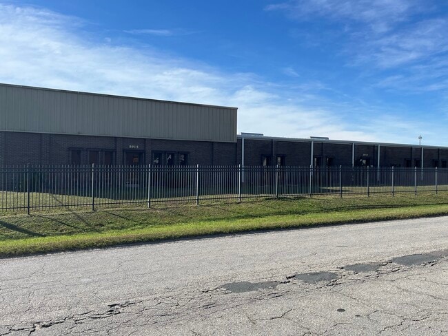

This Property Is For Sale
Current Lease Availabilities
NEARBY LISTINGS FOR SALE OR LEASE
Property Detail
8915 Maislin Dr
Tampa-St. Petersburg-Clearwater, FL
U S 301 Industrial Park
U-25-28-19-1JL-000002-00003.1
U S 301 INDUSTRIAL PARK E 256.59 FT OF LOT 3 BLK 2
Warehouse
Hillsborough
X
Florida
12057C0238H
3
2024
2.69 AC
2024
East Side
010402
Tampa/St Petersburg
29,434 SF
DEMOGRAPHICS near 8915 Maislin Dr
1 Mile
3 Mile
5 Mile
2024 Total Population
4,280
58,523
159,311
2029 Population
4,650
63,807
173,833
Pop Growth 2024-2029
+ 8.64%
+ 9.03%
+ 9.12%
Average Age
38
37
37
2024 Total Households
1,663
22,886
59,900
HH Growth 2024-2029
+ 8.66%
+ 9.22%
+ 9.37%
Median Household Inc
$62,207
$51,691
$46,823
Avg Household Size
2.60
2.50
2.50
2024 Avg HH Vehicles
2.00
2.00
2.00
Median Home Value
$193,447
$256,365
$226,932
Median Year Built
1983
1983
1983
Nearby Places
Map Layers
Map Styles
 Street
 Aerial
- Restaurants
- Banks
- Shops
- Fitness
- Groceries
PUBLIC TRANSPORTATION
AIRPORT
Tampa International
DRIVE
WALK
Distance
Tampa International
27 min
16.3 mi
St Pete-Clearwater International
DRIVE
WALK
Distance
St Pete-Clearwater International
44 min
26.3 mi
Nearby Properties
Address
Land Use
TOTAL SIZE
Lot Size
Zoning
Address
Land Use
TOTAL SIZE
Lot Size
Zoning
1,236,718 SF
38.67 AC
CI
Address
Land Use
TOTAL SIZE
Lot Size
Zoning
2,604,100 SF
83.27 AC
PD
Address
Land Use
TOTAL SIZE
Lot Size
Zoning
702,607 SF
63.42 AC
RCP
Address
Land Use
TOTAL SIZE
Lot Size
Zoning
671,677 SF
72.27 AC
RMFA
Address
Land Use
TOTAL SIZE
Lot Size
Zoning
472,855 SF
34.23 AC
PD
Address
Land Use
TOTAL SIZE
Lot Size
Zoning
319,292 SF
31.71 AC
PD
Address
Land Use
TOTAL SIZE
Lot Size
Zoning
466,038 SF
26.75 AC
PD
Address
Land Use
TOTAL SIZE
Lot Size
Zoning
491,498 SF
35.60 AC
PD
Address
Land Use
TOTAL SIZE
Lot Size
Zoning
665,455 SF
298.65 AC
PD
Address
Land Use
TOTAL SIZE
Lot Size
Zoning
287,530 SF
9.09 AC
PD
Address
Land Use
TOTAL SIZE
Lot Size
Zoning
598,043 SF
48.18 AC
PD
Address
Land Use
TOTAL SIZE
Lot Size
Zoning
250,958 SF
28.28 AC
CI
Address
Land Use
TOTAL SIZE
Lot Size
Zoning
280,650 SF
11.92 AC
UMU-20
Address
Land Use
TOTAL SIZE
Lot Size
Zoning
163,045 SF
32.18 AC
PD
Address
Land Use
TOTAL SIZE
Lot Size
Zoning
193,509 SF
4.67 AC
DMU-35
Address
Land Use
TOTAL SIZE
Lot Size
Zoning
174,144 SF
79.80 AC
PD
Address
Land Use
TOTAL SIZE
Lot Size
Zoning
303,325 SF
17.01 AC
P
Address
Land Use
TOTAL SIZE
Lot Size
Zoning
443,460 SF
16.73 AC
M
Address
Land Use
TOTAL SIZE
Lot Size
Zoning
170,172 SF
18.08 AC
RCP
Address
Land Use
TOTAL SIZE
Lot Size
Zoning
155,769 SF
18.53 AC
CMU-12
Address
Land Use
TOTAL SIZE
Lot Size
Zoning
388,082 SF
30.28 AC
PD
Address
Land Use
TOTAL SIZE
Lot Size
Zoning
271,402 SF
15.93 AC
PD
Address
Land Use
TOTAL SIZE
Lot Size
Zoning
228,193 SF
18.87 AC
RMFA
Address
Land Use
TOTAL SIZE
Lot Size
Zoning
331,265 SF
18.75 AC
RMC-20
Address
Land Use
TOTAL SIZE
Lot Size
Zoning
185,966 SF
14.96 AC
PD
Address
Land Use
TOTAL SIZE
Lot Size
Zoning
217,070 SF
20.83 AC
R-18
Address
Land Use
TOTAL SIZE
Lot Size
Zoning
437,388 SF
30.53 AC
M
Address
Land Use
TOTAL SIZE
Lot Size
Zoning
279,841 SF
24.62 AC
R-18
Address
Land Use
TOTAL SIZE
Lot Size
Zoning
172,220 SF
16.66 AC
RCP
Address
Land Use
TOTAL SIZE
Lot Size
Zoning
331,506 SF
30.38 AC
PD
The World's #1 Commercial Real Estate Marketplace
Connect with us
© 2025 CoStar Group
The information above has been obtained from sources believed reliable. While we do not doubt its accuracy we have not verified it and make no guarantee, warranty or representation about it. It is your responsibility to independently confirm its accuracy and completeness. Any projections, opinions, assumptions, or estimates used are for example only and do not represent the current or future performance of the property. The value of this transaction to you depends on tax and other factors which should be evaluated by your tax, financial, and legal advisors. You and your advisors should conduct a careful, independent investigation of the property to determine to your satisfaction the suitability of the property for your needs.