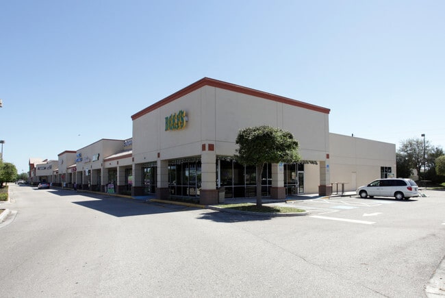
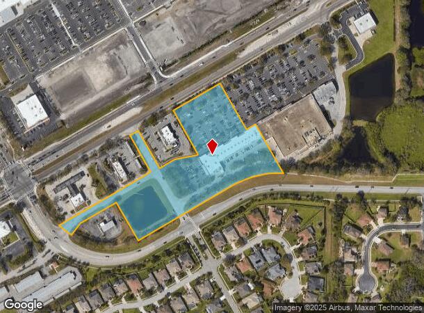
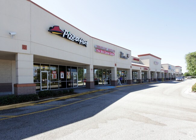
Property Record
8915 Us Highway 301 N, Parrish, FL 34219
NEARBY LISTINGS FOR SALE OR LEASE
-
-
View all Parrish listings for sale on LoopNet.com
Property Detail
8915 Us Highway 301 N
7421-1067-9
PARCEL 3-COM AT THE SE COR OF SEC 2, TWN 34S, RNG 18E; TH N 89 DEG 52 MIN 42 SEC W ALONG THE S LN OF SD SEC 2, A DIST OF 2684.88 FT; TH N 00 DEG 07 MIN 18 SEC E A DIST OF 136.75
Storemultistory
Manatee
A
Florida
12081C0186F
6.66 AC
2023
Manatee
2025
Tampa/St Petersburg
001913
North Port-Sarasota-Bradenton, FL
25,912 SF
DEMOGRAPHICS near 8915 Us Highway 301 N
1 Mile
3 Mile
5 Mile
2024 Total Population
7,273
45,134
96,858
2029 Population
8,565
52,820
113,644
Pop Growth 2024-2029
+ 17.76%
+ 17.03%
+ 17.33%
Average Age
56
48
46
2024 Total Households
3,531
18,817
38,804
HH Growth 2024-2029
+ 17.11%
+ 16.23%
+ 16.44%
Median Household Inc
$55,800
$79,818
$77,425
Avg Household Size
2.00
2.30
2.40
2024 Avg HH Vehicles
1.00
2.00
2.00
Median Home Value
$161,572
$292,980
$306,311
Median Year Built
1992
2005
2003
Nearby Places
Map Layers
Map Styles
 Street
 Aerial
- Restaurants
- Banks
- Shops
- Fitness
- Groceries
PUBLIC TRANSPORTATION
AIRPORT
Sarasota/Bradenton International
DRIVE
WALK
Distance
Sarasota/Bradenton International
30 min
15.9 mi
St Pete-Clearwater International
DRIVE
WALK
Distance
St Pete-Clearwater International
56 min
39.2 mi
Freight Ports
Port Manatee
DRIVE
WALK
Distance
Port Manatee
21 min
11.8 mi
Nearby Properties
Address
Land Use
TOTAL SIZE
Lot Size
Zoning
Address
Land Use
TOTAL SIZE
Lot Size
Zoning
622,266 SF
68.76 AC
PD-MU
Address
Land Use
TOTAL SIZE
Lot Size
Zoning
707,409 SF
27.98 AC
PD-MU
Address
Land Use
TOTAL SIZE
Lot Size
Zoning
359,241 SF
27.68 AC
PD-MU
Address
Land Use
TOTAL SIZE
Lot Size
Zoning
313,422 SF
47.93 AC
PD-C
Address
Land Use
TOTAL SIZE
Lot Size
Zoning
456,375 SF
112.07 AC
PD-MU
Address
Land Use
TOTAL SIZE
Lot Size
Zoning
270,900 SF
44.35 AC
PD-MU
Address
Land Use
TOTAL SIZE
Lot Size
Zoning
456,317 SF
46.75 AC
PD-R
Address
Land Use
TOTAL SIZE
Lot Size
Zoning
312,546 SF
39.60 AC
A-1 SUBURB
Address
Land Use
TOTAL SIZE
Lot Size
Zoning
191,100 SF
30.35 AC
PD-C
Address
Land Use
TOTAL SIZE
Lot Size
Zoning
64,800 SF
8.19 AC
Address
Land Use
TOTAL SIZE
Lot Size
Zoning
13,621 SF
61.72 AC
PD-RV,RSF-
Address
Land Use
TOTAL SIZE
Lot Size
Zoning
61,770 SF
79.85 AC
A,A-1
Address
Land Use
TOTAL SIZE
Lot Size
Zoning
66,063 SF
9.24 AC
PD-C
Address
Land Use
TOTAL SIZE
Lot Size
Zoning
59,222 SF
4.49 AC
PD-C
Address
Land Use
TOTAL SIZE
Lot Size
Zoning
56,442 SF
6.18 AC
GC GENERA
Address
Land Use
TOTAL SIZE
Lot Size
Zoning
138,258 SF
9.59 AC
PD-MU
Address
Land Use
TOTAL SIZE
Lot Size
Zoning
61,721 SF
5.50 AC
PD-C
Address
Land Use
TOTAL SIZE
Lot Size
Zoning
36,002 SF
4.41 AC
PD-C
Address
Land Use
TOTAL SIZE
Lot Size
Zoning
5,744 SF
12.60 AC
RSMH-6
Address
Land Use
TOTAL SIZE
Lot Size
Zoning
7.86 AC
PD-MU
Address
Land Use
TOTAL SIZE
Lot Size
Zoning
32,860 SF
4.05 AC
PD-O
Address
Land Use
TOTAL SIZE
Lot Size
Zoning
28,413 SF
5.40 AC
RSMH-6
Address
Land Use
TOTAL SIZE
Lot Size
Zoning
1,596 SF
106.35 AC
PD-R
Address
Land Use
TOTAL SIZE
Lot Size
Zoning
53,851 SF
6.32 AC
Address
Land Use
TOTAL SIZE
Lot Size
Zoning
41,168 SF
3.21 AC
PD-C
Address
Land Use
TOTAL SIZE
Lot Size
Zoning
22,855 SF
23.30 AC
PD-R
Address
Land Use
TOTAL SIZE
Lot Size
Zoning
23,742 SF
5.21 AC
A-1 SUBURB
Address
Land Use
TOTAL SIZE
Lot Size
Zoning
44,874 SF
394.53 AC
PD-PI
Address
Land Use
TOTAL SIZE
Lot Size
Zoning
34,830 SF
2.95 AC
GC GENERA
The World's #1 Commercial Real Estate Marketplace
Connect with us
© 2026 CoStar Group
The information above has been obtained from sources believed reliable. While we do not doubt its accuracy we have not verified it and make no guarantee, warranty or representation about it. It is your responsibility to independently confirm its accuracy and completeness. Any projections, opinions, assumptions, or estimates used are for example only and do not represent the current or future performance of the property. The value of this transaction to you depends on tax and other factors which should be evaluated by your tax, financial, and legal advisors. You and your advisors should conduct a careful, independent investigation of the property to determine to your satisfaction the suitability of the property for your needs.