Property Record
8916 Double Hills Rd, Denton, MD 21629


Save to a Folder
{{folder.Name}}
{{folder.ListingIds.length}} Properties
{{folder.ListingIds.length}} Property
Create a New Folder
Property Detail
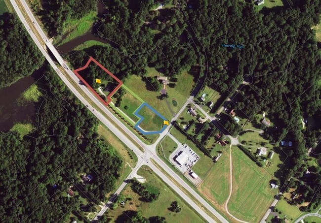
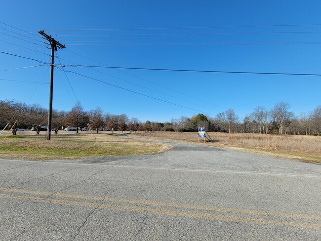
8916 Double Hills Rd
03-034135
1.81 AC L-2 NE/S MD RTE 404 SE OF DENTON
Commercialofficeresidentialmixeduse
Caroline
C2
Maryland
AE The base floodplain where base flood elevations are provided. AE Zones are now used on new format FIRMs instead of A1-A30 Zones.
2
2025
1.81 AC
2025
Chesapeake Bay/Salisbury
955301
Other Market Areas
1,209 SF
NEARBY LISTINGS FOR SALE OR LEASE
DEMOGRAPHICS near 8916 Double Hills Rd
1 mile
3 mile
5 mile
2025 Total Population
369
6,889
10,159
2030 Population
379
7,073
10,434
Pop Growth 2025-2030
+ 2.71%
+ 2.67%
+ 2.71%
Average Age
43
41
41
2025 Total Households
144
2,591
3,769
HH Growth 2025-2030
+ 2.78%
+ 2.74%
+ 2.81%
Median Household Inc
$97,115
$67,434
$70,992
Avg Household Size
2.50
2.50
2.60
2025 Avg HH Vehicles
2.00
2.00
2.00
Median Home Value
$363,636
$307,857
$317,484
Median Year Built
1985
1979
1982
Nearby Places
Map Layers
Map Styles
 Street
 Aerial
Layers
 Traffic
 Biking
Places
Listings with unknown addresses are not visible on the map
- Restaurants
- Banks
- Shops
- Fitness
- Groceries
SALE & LEASE HISTORY
LISTING DATE
SALE/LEASE

Sep 04, 2017
For Sale
Nov 06, 2017
For Sale
Dec 05, 2022
For Sale
Nearby Properties
Address
Land Use
TOTAL SIZE
Lot Size
Zoning
Address
Land Use
TOTAL SIZE
Lot Size
Zoning
49,992 SF
6.05 AC
H-C
Address
Land Use
TOTAL SIZE
Lot Size
Zoning
14,069 SF
12.12 AC
H-C
Address
Land Use
TOTAL SIZE
Lot Size
Zoning
152,426 SF
15.97 AC
RHC
Address
Land Use
TOTAL SIZE
Lot Size
Zoning
47,449 SF
3.76 AC
CM
Address
Land Use
TOTAL SIZE
Lot Size
Zoning
76,504 SF
20.04 AC
MR/TR
Address
Land Use
TOTAL SIZE
Lot Size
Zoning
20,797 SF
5.63 AC
RHC
Address
Land Use
TOTAL SIZE
Lot Size
Zoning
44,195 SF
8.28 AC
SR-R
Address
Land Use
TOTAL SIZE
Lot Size
Zoning
1,215 SF
4.36 AC
CM
Address
Land Use
TOTAL SIZE
Lot Size
Zoning
106,336 SF
6.30 AC
TR
Address
Land Use
TOTAL SIZE
Lot Size
Zoning
20,108 SF
2.52 AC
CBC
Address
Land Use
TOTAL SIZE
Lot Size
Zoning
10,720 SF
8.61 AC
SR
Address
Land Use
TOTAL SIZE
Lot Size
Zoning
4,768 SF
76.31 AC
R
Address
Land Use
TOTAL SIZE
Lot Size
Zoning
45,930 SF
5.43 AC
RHC
Address
Land Use
TOTAL SIZE
Lot Size
Zoning
15,061 SF
37.50 AC
R
Address
Land Use
TOTAL SIZE
Lot Size
Zoning
31,813 SF
5.70 AC
CBC
Address
Land Use
TOTAL SIZE
Lot Size
Zoning
7,559 SF
1.07 AC
CBC
Address
Land Use
TOTAL SIZE
Lot Size
Zoning
22,489 SF
2.90 AC
RHC
Address
Land Use
TOTAL SIZE
Lot Size
Zoning
20,338 SF
0.78 AC
CBC
Address
Land Use
TOTAL SIZE
Lot Size
Zoning
64,429 SF
8.80 AC
LI
Address
Land Use
TOTAL SIZE
Lot Size
Zoning
4,200 SF
4.79 AC
TR
Address
Land Use
TOTAL SIZE
Lot Size
Zoning
3,678 SF
8.20 AC
MR
Address
Land Use
TOTAL SIZE
Lot Size
Zoning
99,200 SF
6.11 AC
LI
Address
Land Use
TOTAL SIZE
Lot Size
Zoning
28,982 SF
1.43 AC
RHC
Address
Land Use
TOTAL SIZE
Lot Size
Zoning
2,993 SF
6.15 AC
H-C
Address
Land Use
TOTAL SIZE
Lot Size
Zoning
5,260 SF
8.72 AC
C2
Address
Land Use
TOTAL SIZE
Lot Size
Zoning
7,614 SF
0.47 AC
CBC
Address
Land Use
TOTAL SIZE
Lot Size
Zoning
20,336 SF
0.22 AC
CBC
Address
Land Use
TOTAL SIZE
Lot Size
Zoning
3,360 SF
10.59 AC
SR
Address
Land Use
TOTAL SIZE
Lot Size
Zoning
90,772 SF
5.85 AC
LI
Address
Land Use
TOTAL SIZE
Lot Size
Zoning
85 AC
R
The World's #1 Commercial Real Estate Marketplace
Connect with us
© 2026 CoStar Group
The information above has been obtained from sources believed reliable. While we do not doubt its accuracy we have not verified it and make no guarantee, warranty or representation about it. It is your responsibility to independently confirm its accuracy and completeness. Any projections, opinions, assumptions, or estimates used are for example only and do not represent the current or future performance of the property. The value of this transaction to you depends on tax and other factors which should be evaluated by your tax, financial, and legal advisors. You and your advisors should conduct a careful, independent investigation of the property to determine to your satisfaction the suitability of the property for your needs.