Property Record
Florin Rd, Sacramento, CA 95829
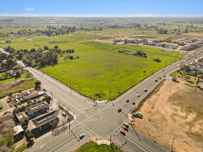


This Property Is For Sale
NEARBY LISTINGS FOR SALE OR LEASE
Property Detail
Florin Rd
065-0051-021
POR NW 1/4 OF NW 1/4 SEC 6 T 7 N, R 6 E M D B &M BEG AT NW COR OF SD SEC 6 BEING THE INTERSECTOF C/L OF FLORIN ELK GROVE RD
Commercialacreage
Sacramento
X
California
06067C0326H
12.83 AC
2024
Outer Sacramento County
2025
Sacramento
009311
Sacramento-Roseville-Folsom, CA
DEMOGRAPHICS near Florin Rd
1 Mile
3 Mile
5 Mile
2024 Total Population
4,673
85,195
291,731
2029 Population
4,722
85,094
291,131
Pop Growth 2024-2029
+ 1.05%
(0.12%)
(0.21%)
Average Age
41
38
38
2024 Total Households
1,613
24,903
91,799
HH Growth 2024-2029
+ 0.68%
(0.20%)
(0.28%)
Median Household Inc
$76,811
$77,578
$72,374
Avg Household Size
2.80
3.30
3.00
2024 Avg HH Vehicles
2.00
2.00
2.00
Median Home Value
$384,119
$408,203
$405,697
Median Year Built
1986
1988
1982
Nearby Places
Map Layers
Map Styles
 Street
 Aerial
- Restaurants
- Banks
- Shops
- Fitness
- Groceries
PUBLIC TRANSPORTATION
AIRPORT
Sacramento International
DRIVE
WALK
Distance
Sacramento International
33 min
23.1 mi
Freight Ports
Port of Stockton
DRIVE
WALK
Distance
Port of Stockton
58 min
47.8 mi
Nearby Properties
Address
Land Use
TOTAL SIZE
Lot Size
Zoning
Address
Land Use
TOTAL SIZE
Lot Size
Zoning
2,317,288 SF
220.58 AC
M-2-SPD
Address
Land Use
TOTAL SIZE
Lot Size
Zoning
45.93 AC
M-2S
Address
Land Use
TOTAL SIZE
Lot Size
Zoning
149,566 SF
9.68 AC
M-2S
Address
Land Use
TOTAL SIZE
Lot Size
Zoning
119,380 SF
18.92 AC
M-2S
Address
Land Use
TOTAL SIZE
Lot Size
Zoning
187,080 SF
10.01 AC
SPA M-1
Address
Land Use
TOTAL SIZE
Lot Size
Zoning
40.67 AC
M-2-SPD
Address
Land Use
TOTAL SIZE
Lot Size
Zoning
584,820 SF
29.12 AC
M-2S
Address
Land Use
TOTAL SIZE
Lot Size
Zoning
198,112 SF
19.62 AC
M-1 M-1 (N
Address
Land Use
TOTAL SIZE
Lot Size
Zoning
7.55 AC
SPA
Address
Land Use
TOTAL SIZE
Lot Size
Zoning
281,404 SF
21.43 AC
M-2
Address
Land Use
TOTAL SIZE
Lot Size
Zoning
261,350 SF
14.41 AC
M-2S
Address
Land Use
TOTAL SIZE
Lot Size
Zoning
319,485 SF
16.35 AC
M-2S
Address
Land Use
TOTAL SIZE
Lot Size
Zoning
158,710 SF
14.02 AC
M-1 (NPA)
Address
Land Use
TOTAL SIZE
Lot Size
Zoning
204,290 SF
11.86 AC
RD-20
Address
Land Use
TOTAL SIZE
Lot Size
Zoning
138,779 SF
44.77 AC
M-2S
Address
Land Use
TOTAL SIZE
Lot Size
Zoning
120,868 SF
53.03 AC
SPA
Address
Land Use
TOTAL SIZE
Lot Size
Zoning
188,144 SF
16.90 AC
M-2S
Address
Land Use
TOTAL SIZE
Lot Size
Zoning
Address
Land Use
TOTAL SIZE
Lot Size
Zoning
55,344 SF
4.75 AC
M-2S
Address
Land Use
TOTAL SIZE
Lot Size
Zoning
143,004 SF
8.81 AC
M-2S
Address
Land Use
TOTAL SIZE
Lot Size
Zoning
12.04 AC
M-1S-R
Address
Land Use
TOTAL SIZE
Lot Size
Zoning
161,834 SF
15.23 AC
LC
Address
Land Use
TOTAL SIZE
Lot Size
Zoning
5.29 AC
M-2S
Address
Land Use
TOTAL SIZE
Lot Size
Zoning
6.90 AC
RD-20
Address
Land Use
TOTAL SIZE
Lot Size
Zoning
5,574 SF
10.34 AC
M-2S
Address
Land Use
TOTAL SIZE
Lot Size
Zoning
167,152 SF
7.53 AC
RD-20
Address
Land Use
TOTAL SIZE
Lot Size
Zoning
273,000 SF
14.38 AC
M-1S-SWR
Address
Land Use
TOTAL SIZE
Lot Size
Zoning
75,765 SF
19.04 AC
M-1S-R
Address
Land Use
TOTAL SIZE
Lot Size
Zoning
126,925 SF
10.35 AC
SPA
Address
Land Use
TOTAL SIZE
Lot Size
Zoning
144,000 SF
5.79 AC
SPA
The World's #1 Commercial Real Estate Marketplace
Connect with us
© 2026 CoStar Group
The information above has been obtained from sources believed reliable. While we do not doubt its accuracy we have not verified it and make no guarantee, warranty or representation about it. It is your responsibility to independently confirm its accuracy and completeness. Any projections, opinions, assumptions, or estimates used are for example only and do not represent the current or future performance of the property. The value of this transaction to you depends on tax and other factors which should be evaluated by your tax, financial, and legal advisors. You and your advisors should conduct a careful, independent investigation of the property to determine to your satisfaction the suitability of the property for your needs.