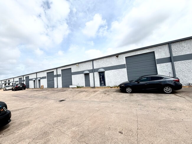
Property Record
8922 Frey Rd, Houston, TX 77034


Current Lease Availabilities
Property Detail
8922 Frey Rd
Houston-Pasadena-The Woodlands, TX
LT 30 BLK 1 ACRE HOMES
0031390010030
HARRIS
Warehouse
Texas
B and X Area of moderate flood hazard, usually the area between the limits of the 100-year and 500-year floods.
30
2024
0.91 AC
2025
East-Southeast Far
321001
Houston
18,900 SF
NEARBY LISTINGS FOR SALE OR LEASE
DEMOGRAPHICS near 8922 Frey Rd
1 mile
3 mile
5 mile
2025 Total Population
19,177
134,100
314,630
2030 Population
20,336
142,610
335,295
Pop Growth 2025-2030
+ 6.04%
+ 6.35%
+ 6.57%
Average Age
34
35
36
2025 Total Households
6,418
43,450
102,880
HH Growth 2025-2030
+ 6.40%
+ 6.57%
+ 6.81%
Median Household Inc
$54,155
$61,105
$64,231
Avg Household Size
2.90
3.00
3.00
2025 Avg HH Vehicles
2.00
2.00
2.00
Median Home Value
$189,972
$224,097
$235,011
Median Year Built
1978
1979
1977
Nearby Places
Map Layers
Map Styles
 Street
 Aerial
Layers
 Traffic
 Biking
Places
Listings with unknown addresses are not visible on the map
- Restaurants
- Banks
- Shops
- Fitness
- Groceries
PUBLIC TRANSPORTATION
AIRPORT
William P Hobby
Drive
Walk
Distance
William P Hobby
13 min
4.4 mi
George Bush Intcntl/Houston
Drive
Walk
Distance
George Bush Intcntl/Houston
42 min
33.8 mi
Freight Ports
Port of Houston
Drive
Walk
Distance
Port of Houston
19 min
10.8 mi
Nearby Properties
Address
Land Use
TOTAL SIZE
Lot Size
Zoning
Address
Land Use
TOTAL SIZE
Lot Size
Zoning
690,590 SF
31.88 AC
Address
Land Use
TOTAL SIZE
Lot Size
Zoning
794,499 SF
31.71 AC
Address
Land Use
TOTAL SIZE
Lot Size
Zoning
334,780 SF
13.48 AC
Address
Land Use
TOTAL SIZE
Lot Size
Zoning
331,734 SF
15.82 AC
Address
Land Use
TOTAL SIZE
Lot Size
Zoning
369,871 SF
13.68 AC
Address
Land Use
TOTAL SIZE
Lot Size
Zoning
229,446 SF
21.05 AC
Address
Land Use
TOTAL SIZE
Lot Size
Zoning
411,252 SF
18.28 AC
Address
Land Use
TOTAL SIZE
Lot Size
Zoning
279,627 SF
15.98 AC
Address
Land Use
TOTAL SIZE
Lot Size
Zoning
397,739 SF
15.93 AC
Address
Land Use
TOTAL SIZE
Lot Size
Zoning
342,149 SF
23.56 AC
Address
Land Use
TOTAL SIZE
Lot Size
Zoning
227,864 SF
9.83 AC
Address
Land Use
TOTAL SIZE
Lot Size
Zoning
245,028 SF
12.44 AC
Address
Land Use
TOTAL SIZE
Lot Size
Zoning
262,774 SF
10.87 AC
Address
Land Use
TOTAL SIZE
Lot Size
Zoning
230,218 SF
10.67 AC
Address
Land Use
TOTAL SIZE
Lot Size
Zoning
186,046 SF
13.34 AC
Address
Land Use
TOTAL SIZE
Lot Size
Zoning
188,110 SF
2.22 AC
Address
Land Use
TOTAL SIZE
Lot Size
Zoning
219,424 SF
7.25 AC
Address
Land Use
TOTAL SIZE
Lot Size
Zoning
Address
Land Use
TOTAL SIZE
Lot Size
Zoning
203,158 SF
10 AC
Address
Land Use
TOTAL SIZE
Lot Size
Zoning
241,245 SF
9 AC
Address
Land Use
TOTAL SIZE
Lot Size
Zoning
136,335 SF
4.32 AC
Address
Land Use
TOTAL SIZE
Lot Size
Zoning
391,576 SF
19.94 AC
Address
Land Use
TOTAL SIZE
Lot Size
Zoning
446,728 SF
16.69 AC
Address
Land Use
TOTAL SIZE
Lot Size
Zoning
224,598 SF
11 AC
Address
Land Use
TOTAL SIZE
Lot Size
Zoning
169,338 SF
10.19 AC
Address
Land Use
TOTAL SIZE
Lot Size
Zoning
273,091 SF
10.75 AC
Address
Land Use
TOTAL SIZE
Lot Size
Zoning
152,276 SF
6.83 AC
Address
Land Use
TOTAL SIZE
Lot Size
Zoning
155,316 SF
4.26 AC
Address
Land Use
TOTAL SIZE
Lot Size
Zoning
171,935 SF
11.83 AC
Address
Land Use
TOTAL SIZE
Lot Size
Zoning
148,765 SF
7.20 AC
The World's #1 Commercial Real Estate Marketplace
Connect with us
© 2026 CoStar Group
The information above has been obtained from sources believed reliable. While we do not doubt its accuracy we have not verified it and make no guarantee, warranty or representation about it. It is your responsibility to independently confirm its accuracy and completeness. Any projections, opinions, assumptions, or estimates used are for example only and do not represent the current or future performance of the property. The value of this transaction to you depends on tax and other factors which should be evaluated by your tax, financial, and legal advisors. You and your advisors should conduct a careful, independent investigation of the property to determine to your satisfaction the suitability of the property for your needs.