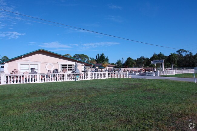
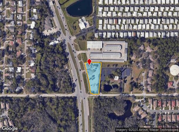
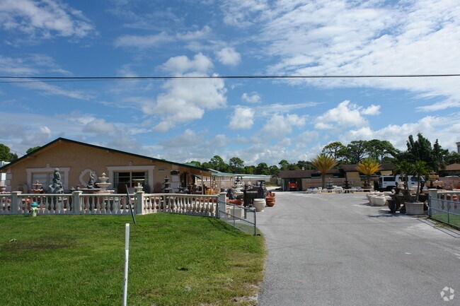
Property Record
8927 S Tamiami Trl, Sarasota, FL 34238

NEARBY LISTINGS FOR SALE OR LEASE
Property Detail
8927 S Tamiami Trl
North Port-Bradenton-Sarasota, FL
Sarasota-Venice Co Sub 34-37-18
0132-14-0038
PARCEL LOCATED IN NW 1/4 OF SEC 34-37-18 DESC AS COM AT SE COR OF NW 1/4 SAID SEC 34 TH N 03-16-14 E 15.82 FOR POB TH ALONG N R/W OF VAMO WAY AS SHOWN IN RPB 1 PG 66-79 NEXT 3 CALLS:
Storemultistory
Sarasota
AE
Florida
12115C0226G
12
2024
1.26 AC
2025
Sarasota
002007
Tampa/St Petersburg
1,976 SF
DEMOGRAPHICS near 8927 S Tamiami Trl
1 Mile
3 Mile
5 Mile
2024 Total Population
6,733
37,764
85,844
2029 Population
7,720
43,887
99,866
Pop Growth 2024-2029
+ 14.66%
+ 16.21%
+ 16.33%
Average Age
57
57
54
2024 Total Households
3,636
19,299
41,805
HH Growth 2024-2029
+ 14.69%
+ 16.32%
+ 16.52%
Median Household Inc
$72,764
$86,885
$81,481
Avg Household Size
1.80
1.90
2.00
2024 Avg HH Vehicles
2.00
2.00
2.00
Median Home Value
$348,024
$446,218
$414,900
Median Year Built
1991
1993
1987
Nearby Places
Map Layers
Map Styles
 Street
 Aerial
- Restaurants
- Banks
- Shops
- Fitness
- Groceries
PUBLIC TRANSPORTATION
AIRPORT
Sarasota/Bradenton International
DRIVE
WALK
Distance
Sarasota/Bradenton International
27 min
14.4 mi
Freight Ports
Port Manatee
DRIVE
WALK
Distance
Port Manatee
49 min
35.5 mi
SALE & LEASE HISTORY
LISTING DATE
SALE/LEASE

Jul 13, 2018
For Sale
Nearby Properties
Address
Land Use
TOTAL SIZE
Lot Size
Zoning
Address
Land Use
TOTAL SIZE
Lot Size
Zoning
912,672 SF
88.39 AC
RMF1
Address
Land Use
TOTAL SIZE
Lot Size
Zoning
530,029 SF
14.92 AC
RMF4
Address
Land Use
TOTAL SIZE
Lot Size
Zoning
318,414 SF
22.35 AC
RMF1
Address
Land Use
TOTAL SIZE
Lot Size
Zoning
242,685 SF
26.67 AC
RMF1
Address
Land Use
TOTAL SIZE
Lot Size
Zoning
312,294 SF
40.21 AC
OPI
Address
Land Use
TOTAL SIZE
Lot Size
Zoning
286,775 SF
10.85 AC
RMF3
Address
Land Use
TOTAL SIZE
Lot Size
Zoning
181,467 SF
59.39 AC
RMF1
Address
Land Use
TOTAL SIZE
Lot Size
Zoning
244,492 SF
73.19 AC
GU
Address
Land Use
TOTAL SIZE
Lot Size
Zoning
175,813 SF
10.09 AC
CG
Address
Land Use
TOTAL SIZE
Lot Size
Zoning
17,785 SF
56.32 AC
RMF2
Address
Land Use
TOTAL SIZE
Lot Size
Zoning
148,339 SF
12.86 AC
CG
Address
Land Use
TOTAL SIZE
Lot Size
Zoning
123,338 SF
8.53 AC
OPI
Address
Land Use
TOTAL SIZE
Lot Size
Zoning
124,423 SF
76 AC
GU
Address
Land Use
TOTAL SIZE
Lot Size
Zoning
145,945 SF
13.93 AC
CG
Address
Land Use
TOTAL SIZE
Lot Size
Zoning
73,121 SF
426.09 AC
OUE2
Address
Land Use
TOTAL SIZE
Lot Size
Zoning
209,566 SF
18.63 AC
CG
Address
Land Use
TOTAL SIZE
Lot Size
Zoning
46,727 SF
38.73 AC
CG
Address
Land Use
TOTAL SIZE
Lot Size
Zoning
64,581 SF
11.85 AC
CG
Address
Land Use
TOTAL SIZE
Lot Size
Zoning
49,691 SF
360.97 AC
RSF2
Address
Land Use
TOTAL SIZE
Lot Size
Zoning
150,217 SF
14.83 AC
CG
Address
Land Use
TOTAL SIZE
Lot Size
Zoning
88,509 SF
12.03 AC
CG
Address
Land Use
TOTAL SIZE
Lot Size
Zoning
111,041 SF
20 AC
CG
Address
Land Use
TOTAL SIZE
Lot Size
Zoning
8,407 SF
30.21 AC
RSF1
Address
Land Use
TOTAL SIZE
Lot Size
Zoning
7,969 SF
38.20 AC
RMH
Address
Land Use
TOTAL SIZE
Lot Size
Zoning
98,877 SF
7.07 AC
RSF2
Address
Land Use
TOTAL SIZE
Lot Size
Zoning
15,095 SF
2.78 AC
RE2
Address
Land Use
TOTAL SIZE
Lot Size
Zoning
704 SF
1.80 AC
RSF1
Address
Land Use
TOTAL SIZE
Lot Size
Zoning
44,403 SF
20.98 AC
RSF3
Address
Land Use
TOTAL SIZE
Lot Size
Zoning
16,879 SF
8.60 AC
RE2
Address
Land Use
TOTAL SIZE
Lot Size
Zoning
50,580 SF
3.37 AC
CI
The World's #1 Commercial Real Estate Marketplace
Connect with us
© 2026 CoStar Group
The information above has been obtained from sources believed reliable. While we do not doubt its accuracy we have not verified it and make no guarantee, warranty or representation about it. It is your responsibility to independently confirm its accuracy and completeness. Any projections, opinions, assumptions, or estimates used are for example only and do not represent the current or future performance of the property. The value of this transaction to you depends on tax and other factors which should be evaluated by your tax, financial, and legal advisors. You and your advisors should conduct a careful, independent investigation of the property to determine to your satisfaction the suitability of the property for your needs.