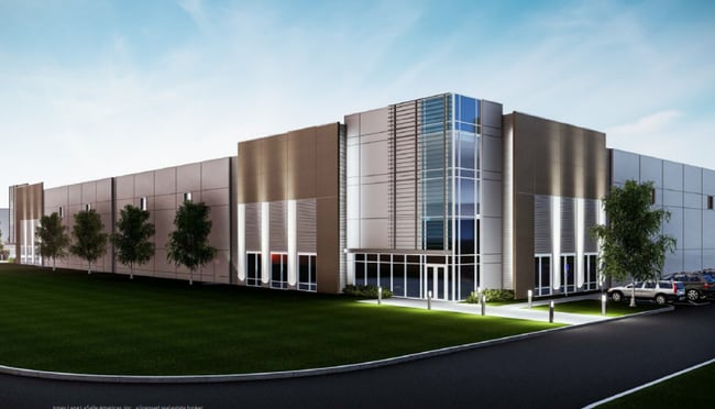
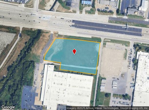
Property Record
8930 Pershall Rd, Hazelwood, MO 63042
Current Lease Availabilities
NEARBY LISTINGS FOR SALE OR LEASE
Property Detail
8930 Pershall Rd
St. Louis, MO-IL
Value Place Hazelwood Lots 1 & 2 &
09K-23-0204
VALUE PLACE HAZELWOOD LOTS 1 & 2 & BARNEY HANLEY ESTATE LOT PT 4 & SURVEYS 146 & 939-47-6 RESUB (AKA BERNADETTE PLAT 2) LOT A CONSOLIDATION NEW LOT A & NEW LOT 1 BDY ADJ ADJ NEW LOT PT 1
Vacantlandnec
St. Louis
X
Missouri
29183C0325G
1,2,4
2024
5.31 AC
2025
Airport
211500
St. Louis
DEMOGRAPHICS near 8930 Pershall Rd
1 mile
3 mile
5 mile
2024 Total Population
7,023
76,326
198,815
2029 Population
6,886
74,929
196,144
Pop Growth 2024-2029
(1.95%)
(1.83%)
(1.34%)
Average Age
38
39
39
2024 Total Households
3,168
31,169
80,508
HH Growth 2024-2029
(1.93%)
(1.90%)
(1.38%)
Median Household Inc
$40,314
$55,498
$53,651
Avg Household Size
2.20
2.40
2.40
2024 Avg HH Vehicles
1.00
2.00
2.00
Median Home Value
$124,233
$134,992
$133,036
Median Year Built
1966
1962
1963
Nearby Places
Map Layers
Map Styles
 Street
 Aerial
Transit
 Traffic
 Biking
Places
Listings with unknown addresses are not visible on the map
- Restaurants
- Banks
- Shops
- Fitness
- Groceries
PUBLIC TRANSPORTATION
COMMUTER RAIL
Lambert Airport East Terminal (Lambert Airport Shiloh-Scott - St. Louis MetroLink (MetroLink))
Drive
Walk
Distance
Lambert Airport East Terminal (Lambert Airport Shiloh-Scott - St. Louis MetroLink (MetroLink))
8 min
5.1 mi
Lambert Airport Main Terminal (Lambert Airport Shiloh-Scott - St. Louis MetroLink (MetroLink))
Drive
Walk
Distance
Lambert Airport Main Terminal (Lambert Airport Shiloh-Scott - St. Louis MetroLink (MetroLink))
10 min
5.6 mi
AIRPORT
St Louis Lambert International
Drive
Walk
Distance
St Louis Lambert International
7 min
3.5 mi
Freight Ports
Port Milwaukee
Drive
Walk
Distance
Port Milwaukee
425 min
374.3 mi
Nearby Properties
Address
Land Use
TOTAL SIZE
Lot Size
Zoning
Address
Land Use
TOTAL SIZE
Lot Size
Zoning
1,770,455 SF
1,090.47 AC
NU
Address
Land Use
TOTAL SIZE
Lot Size
Zoning
1,817,830 SF
75.99 AC
M1
Address
Land Use
TOTAL SIZE
Lot Size
Zoning
2,640,818 SF
159.97 AC
7M-1
Address
Land Use
TOTAL SIZE
Lot Size
Zoning
4,416 SF
54.81 AC
80B
Address
Land Use
TOTAL SIZE
Lot Size
Zoning
378,915 SF
12.16 AC
73C
Address
Land Use
TOTAL SIZE
Lot Size
Zoning
71.29 AC
24R4
Address
Land Use
TOTAL SIZE
Lot Size
Zoning
893,188 SF
71.88 AC
G
Address
Land Use
TOTAL SIZE
Lot Size
Zoning
815,658 SF
28.70 AC
M1
Address
Land Use
TOTAL SIZE
Lot Size
Zoning
816,783 SF
37.97 AC
7M-1
Address
Land Use
TOTAL SIZE
Lot Size
Zoning
528,000 SF
21.10 AC
80I
Address
Land Use
TOTAL SIZE
Lot Size
Zoning
35.96 AC
R2
Address
Land Use
TOTAL SIZE
Lot Size
Zoning
136,258 SF
263.16 AC
7M-1
Address
Land Use
TOTAL SIZE
Lot Size
Zoning
277,926 SF
12.61 AC
67C-2
Address
Land Use
TOTAL SIZE
Lot Size
Zoning
406,000 SF
18.82 AC
80CA
Address
Land Use
TOTAL SIZE
Lot Size
Zoning
445,715 SF
28.16 AC
80I
Address
Land Use
TOTAL SIZE
Lot Size
Zoning
335,294 SF
33.83 AC
24MFD
Address
Land Use
TOTAL SIZE
Lot Size
Zoning
6.88 AC
H
Address
Land Use
TOTAL SIZE
Lot Size
Zoning
18,734 SF
38.83 AC
24R4
Address
Land Use
TOTAL SIZE
Lot Size
Zoning
1,428 SF
131.27 AC
C
Address
Land Use
TOTAL SIZE
Lot Size
Zoning
206,787 SF
37.07 AC
72R1
Address
Land Use
TOTAL SIZE
Lot Size
Zoning
293,622 SF
28.06 AC
H
Address
Land Use
TOTAL SIZE
Lot Size
Zoning
659,138 SF
1,142.84 AC
M1
Address
Land Use
TOTAL SIZE
Lot Size
Zoning
262,938 SF
11.32 AC
80H
Address
Land Use
TOTAL SIZE
Lot Size
Zoning
161,536 SF
7.91 AC
R5
Address
Land Use
TOTAL SIZE
Lot Size
Zoning
269,258 SF
89.80 AC
80F
Address
Land Use
TOTAL SIZE
Lot Size
Zoning
214,280 SF
22.39 AC
NU
Address
Land Use
TOTAL SIZE
Lot Size
Zoning
106,957 SF
6.10 AC
C
Address
Land Use
TOTAL SIZE
Lot Size
Zoning
320,176 SF
9.83 AC
24MFD
Address
Land Use
TOTAL SIZE
Lot Size
Zoning
135,721 SF
5.40 AC
80F
Address
Land Use
TOTAL SIZE
Lot Size
Zoning
387,158 SF
34.19 AC
R6
The World's #1 Commercial Real Estate Marketplace
Connect with us
© 2026 CoStar Group
The information above has been obtained from sources believed reliable. While we do not doubt its accuracy we have not verified it and make no guarantee, warranty or representation about it. It is your responsibility to independently confirm its accuracy and completeness. Any projections, opinions, assumptions, or estimates used are for example only and do not represent the current or future performance of the property. The value of this transaction to you depends on tax and other factors which should be evaluated by your tax, financial, and legal advisors. You and your advisors should conduct a careful, independent investigation of the property to determine to your satisfaction the suitability of the property for your needs.