Property Record
8930 Liberty Rd, Randallstown, MD 21133
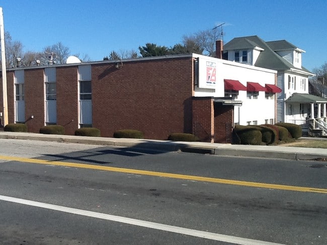


Property Detail
8930 Liberty Rd
02-0213201280
PT LT 111 .3488 AC FIELDSTONE
Officebuilding
Baltimore
RO
Maryland
B and X Area of moderate flood hazard, usually the area between the limits of the 100-year and 500-year floods.
111
2024
0.35 AC
2025
Reisterstown Rd Corridor
402604
Baltimore
2,565 SF
Baltimore-Columbia-Towson, MD
NEARBY LISTINGS FOR SALE OR LEASE
DEMOGRAPHICS near 8930 Liberty Rd
1 mile
3 mile
5 mile
2025 Total Population
12,968
80,947
186,260
2030 Population
12,933
80,907
186,347
Pop Growth 2025-2030
(0.27%)
(0.05%)
+ 0.05%
Average Age
42
41
41
2025 Total Households
4,767
31,708
72,850
HH Growth 2025-2030
(0.23%)
(0.04%)
+ 0.05%
Median Household Inc
$80,225
$89,575
$86,539
Avg Household Size
2.60
2.50
2.50
2025 Avg HH Vehicles
2.00
2.00
2.00
Median Home Value
$321,344
$322,034
$322,321
Median Year Built
1970
1984
1978
Nearby Places
Map Layers
Map Styles
 Street
 Aerial
Layers
 Traffic
 Biking
Places
Listings with unknown addresses are not visible on the map
- Restaurants
- Banks
- Shops
- Fitness
- Groceries
PUBLIC TRANSPORTATION
AIRPORT
Baltimore/Washington International Thurgood Marshall
Drive
Walk
Distance
Baltimore/Washington International Thurgood Marshall
29 min
16.6 mi
Freight Ports
Port of Baltimore
Drive
Walk
Distance
Port of Baltimore
29 min
16.9 mi
SALE & LEASE HISTORY
LISTING DATE
SALE/LEASE

Mar 25, 2020
For Lease
Jul 08, 2019
For Lease
Feb 11, 2019
For Lease
Nearby Properties
Address
Land Use
TOTAL SIZE
Lot Size
Zoning
Address
Land Use
TOTAL SIZE
Lot Size
Zoning
630,367 SF
470.44 AC
DR1
Address
Land Use
TOTAL SIZE
Lot Size
Zoning
250,000 SF
1.61 AC
BMCT
Address
Land Use
TOTAL SIZE
Lot Size
Zoning
452,042 SF
17.18 AC
RAE2
Address
Land Use
TOTAL SIZE
Lot Size
Zoning
709,328 SF
25.59 AC
OT
Address
Land Use
TOTAL SIZE
Lot Size
Zoning
256,960 SF
32 AC
Address
Land Use
TOTAL SIZE
Lot Size
Zoning
12 AC
DR10
Address
Land Use
TOTAL SIZE
Lot Size
Zoning
4.31 AC
BM-CT
Address
Land Use
TOTAL SIZE
Lot Size
Zoning
300,838 SF
33.27 AC
DR105
Address
Land Use
TOTAL SIZE
Lot Size
Zoning
336,539 SF
12.38 AC
DR16
Address
Land Use
TOTAL SIZE
Lot Size
Zoning
Address
Land Use
TOTAL SIZE
Lot Size
Zoning
325,203 SF
6.24 AC
DR5.5
Address
Land Use
TOTAL SIZE
Lot Size
Zoning
464,593 SF
6.38 AC
BM
Address
Land Use
TOTAL SIZE
Lot Size
Zoning
16.48 AC
DR16
Address
Land Use
TOTAL SIZE
Lot Size
Zoning
26.88 AC
DR16
Address
Land Use
TOTAL SIZE
Lot Size
Zoning
281,620 SF
8.58 AC
Address
Land Use
TOTAL SIZE
Lot Size
Zoning
756,000 SF
2.63 AC
Address
Land Use
TOTAL SIZE
Lot Size
Zoning
224,204 SF
7.64 AC
RAE2
Address
Land Use
TOTAL SIZE
Lot Size
Zoning
589,225 SF
1.96 AC
Address
Land Use
TOTAL SIZE
Lot Size
Zoning
13.82 AC
DR16
Address
Land Use
TOTAL SIZE
Lot Size
Zoning
146,149 SF
1.08 AC
BM-CT
Address
Land Use
TOTAL SIZE
Lot Size
Zoning
Address
Land Use
TOTAL SIZE
Lot Size
Zoning
14.36 AC
DR16
Address
Land Use
TOTAL SIZE
Lot Size
Zoning
11.96 AC
DR16
Address
Land Use
TOTAL SIZE
Lot Size
Zoning
252,674 SF
11.49 AC
DR16
Address
Land Use
TOTAL SIZE
Lot Size
Zoning
91,160 SF
2.53 AC
Address
Land Use
TOTAL SIZE
Lot Size
Zoning
190,068 SF
8.40 AC
RAE2
Address
Land Use
TOTAL SIZE
Lot Size
Zoning
139,899 SF
9.39 AC
DR3.5
Address
Land Use
TOTAL SIZE
Lot Size
Zoning
451,526 SF
11.11 AC
RT
Address
Land Use
TOTAL SIZE
Lot Size
Zoning
190,501 SF
1.63 AC
Address
Land Use
TOTAL SIZE
Lot Size
Zoning
140,286 SF
11.71 AC
BR
The World's #1 Commercial Real Estate Marketplace
Connect with us
© 2026 CoStar Group
The information above has been obtained from sources believed reliable. While we do not doubt its accuracy we have not verified it and make no guarantee, warranty or representation about it. It is your responsibility to independently confirm its accuracy and completeness. Any projections, opinions, assumptions, or estimates used are for example only and do not represent the current or future performance of the property. The value of this transaction to you depends on tax and other factors which should be evaluated by your tax, financial, and legal advisors. You and your advisors should conduct a careful, independent investigation of the property to determine to your satisfaction the suitability of the property for your needs.