Property Record
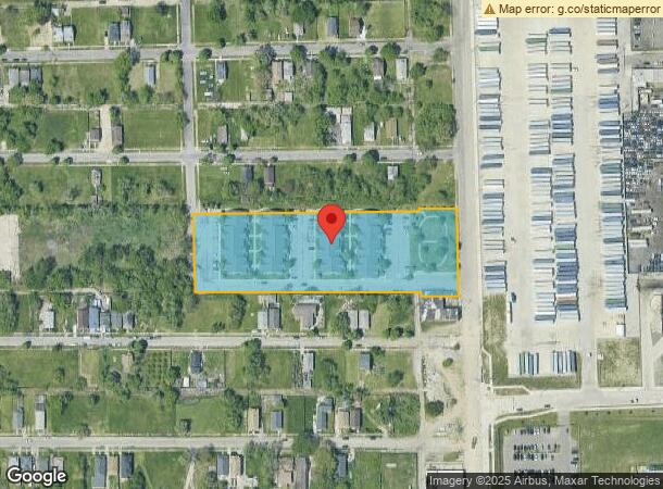
8931 Mount Elliott St, Detroit, MI 48211
NEARBY LISTINGS FOR SALE OR LEASE
Property Detail
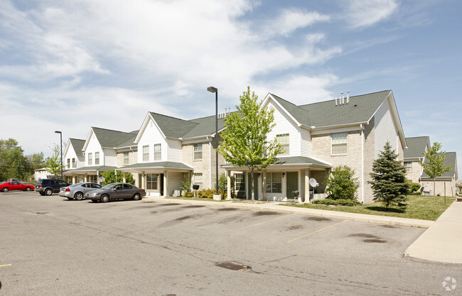
8931 Mount Elliott St
13-009635
Plat Of
Multifamilydwelling
W MT ELLIOTT E 703.15 FT ON N LINE BG E 703.04 FT ON S LINE OF O L 1 LYG W & ADJ MT ELLIOTT AVE EXC ALLEYS AS OPENED PLAT OF SUB OF S W 1/4 SEC 21 T 1 S R 12 E L3 P12 PLATS, W C R 13/204 149,559 SQ FT
X
Wayne
26163C0125E
Michigan
2025
3.43 AC
2025
Hamtramck
505800
Detroit
70,152 SF
Detroit-Warren-Dearborn, MI
DEMOGRAPHICS near 8931 Mount Elliott St
1 Mile
3 Mile
5 Mile
2024 Total Population
15,520
120,508
364,981
2029 Population
14,915
120,465
367,709
Pop Growth 2024-2029
(3.90%)
(0.04%)
+ 0.75%
Average Age
32
37
38
2024 Total Households
4,396
45,100
150,749
HH Growth 2024-2029
(3.48%)
+ 0.33%
+ 0.72%
Median Household Inc
$32,861
$33,552
$35,494
Avg Household Size
3.40
2.50
2.30
2024 Avg HH Vehicles
1.00
1.00
1.00
Median Home Value
$93,324
$77,602
$80,161
Median Year Built
1947
1948
1949
Nearby Places
Map Layers
Map Styles
 Street
 Aerial
- Restaurants
- Banks
- Shops
- Fitness
- Groceries
PUBLIC TRANSPORTATION
COMMUTER RAIL
Detroit (Wolverine - Amtrak)
DRIVE
WALK
Distance
Detroit (Wolverine - Amtrak)
9 min
3.7 mi
Windsor (Toronto - Windsor - VIA Rail)
DRIVE
WALK
Distance
Windsor (Toronto - Windsor - VIA Rail)
21 min
9.2 mi
AIRPORT
Windsor International
DRIVE
WALK
Distance
Windsor International
34 min
15.1 mi
Detroit Metro Wayne County
DRIVE
WALK
Distance
Detroit Metro Wayne County
37 min
24.6 mi
Freight Ports
Port of Toledo
DRIVE
WALK
Distance
Port of Toledo
83 min
65.4 mi
Nearby Properties
Address
Land Use
TOTAL SIZE
Lot Size
Zoning
Address
Land Use
TOTAL SIZE
Lot Size
Zoning
3,793,609 SF
265.70 AC
M4
Address
Land Use
TOTAL SIZE
Lot Size
Zoning
334,904 SF
B5
Address
Land Use
TOTAL SIZE
Lot Size
Zoning
627,489 SF
5.82 AC
B4
Address
Land Use
TOTAL SIZE
Lot Size
Zoning
506,450 SF
3.84 AC
B5
Address
Land Use
TOTAL SIZE
Lot Size
Zoning
266,016 SF
7.76 AC
PD
Address
Land Use
TOTAL SIZE
Lot Size
Zoning
82,528 SF
6.03 AC
PD
Address
Land Use
TOTAL SIZE
Lot Size
Zoning
167,000 SF
1.83 AC
PD
Address
Land Use
TOTAL SIZE
Lot Size
Zoning
996,200 SF
2.14 AC
Address
Land Use
TOTAL SIZE
Lot Size
Zoning
332,208 SF
2.72 AC
R6
Address
Land Use
TOTAL SIZE
Lot Size
Zoning
152,232 SF
SD2
Address
Land Use
TOTAL SIZE
Lot Size
Zoning
531,360 SF
1.44 AC
B5
Address
Land Use
TOTAL SIZE
Lot Size
Zoning
506,404 SF
198 AC
M4
Address
Land Use
TOTAL SIZE
Lot Size
Zoning
678,539 SF
3.52 AC
B5
Address
Land Use
TOTAL SIZE
Lot Size
Zoning
65,625 SF
2.70 AC
PD
Address
Land Use
TOTAL SIZE
Lot Size
Zoning
158,535 SF
B4
Address
Land Use
TOTAL SIZE
Lot Size
Zoning
164,797 SF
2.03 AC
Address
Land Use
TOTAL SIZE
Lot Size
Zoning
892,351 SF
92.45 AC
I
Address
Land Use
TOTAL SIZE
Lot Size
Zoning
449,083 SF
2.39 AC
B2
Address
Land Use
TOTAL SIZE
Lot Size
Zoning
191,837 SF
16.99 AC
PD
Address
Land Use
TOTAL SIZE
Lot Size
Zoning
76,986 SF
2.73 AC
B4
Address
Land Use
TOTAL SIZE
Lot Size
Zoning
331,559 SF
11.42 AC
M4
Address
Land Use
TOTAL SIZE
Lot Size
Zoning
564,958 SF
9.69 AC
M4
Address
Land Use
TOTAL SIZE
Lot Size
Zoning
135,296 SF
1.09 AC
R5
Address
Land Use
TOTAL SIZE
Lot Size
Zoning
252,294 SF
11.54 AC
R6
Address
Land Use
TOTAL SIZE
Lot Size
Zoning
263,240 SF
1.21 AC
B4
Address
Land Use
TOTAL SIZE
Lot Size
Zoning
185,944 SF
B2
Address
Land Use
TOTAL SIZE
Lot Size
Zoning
224,410 SF
2.11 AC
M3
Address
Land Use
TOTAL SIZE
Lot Size
Zoning
144,578 SF
7.10 AC
PD
Address
Land Use
TOTAL SIZE
Lot Size
Zoning
115,560 SF
1 AC
B4
Address
Land Use
TOTAL SIZE
Lot Size
Zoning
48,568 SF
0.28 AC
SD2
The World's #1 Commercial Real Estate Marketplace
Connect with us
© 2025 CoStar Group
The information above has been obtained from sources believed reliable. While we do not doubt its accuracy we have not verified it and make no guarantee, warranty or representation about it. It is your responsibility to independently confirm its accuracy and completeness. Any projections, opinions, assumptions, or estimates used are for example only and do not represent the current or future performance of the property. The value of this transaction to you depends on tax and other factors which should be evaluated by your tax, financial, and legal advisors. You and your advisors should conduct a careful, independent investigation of the property to determine to your satisfaction the suitability of the property for your needs.