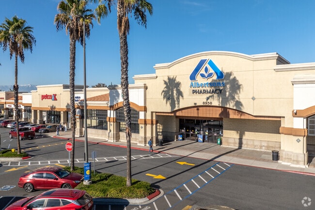
Property Record
8938 Trautwein Rd, Riverside, CA 92508
Property Detail
8938 Trautwein Rd
Riverside-San Bernardino-Ontario, CA
3.91 ACRES IN POR PAR 5 PM 189/014 PM 28353
284-250-005
RIVERSIDE
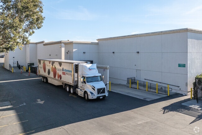
Supermarket
California
D Areas with possible but undetermined flood hazards.
5
2024
3.91 AC
2025
Moreno Valley/Perris
042018
Inland Empire (California)
NEARBY LISTINGS FOR SALE OR LEASE
DEMOGRAPHICS near 8938 Trautwein Rd
1 mile
3 mile
5 mile
2025 Total Population
14,415
48,248
140,764
2030 Population
14,641
49,277
143,691
Pop Growth 2025-2030
+ 1.57%
+ 2.13%
+ 2.08%
Average Age
37
39
37
2025 Total Households
3,942
13,923
42,008
HH Growth 2025-2030
+ 0.99%
+ 1.83%
+ 1.77%
Median Household Inc
$146,293
$137,214
$107,420
Avg Household Size
3.50
3.30
3.20
2025 Avg HH Vehicles
3.00
3.00
2.00
Median Home Value
$736,801
$747,927
$701,212
Median Year Built
1998
1993
1987
Nearby Places
Map Layers
Map Styles
 Street
 Aerial
Layers
 Traffic
 Biking
Places
Listings with unknown addresses are not visible on the map
- Restaurants
- Banks
- Shops
- Fitness
- Groceries
PUBLIC TRANSPORTATION
COMMUTER RAIL
Drive
Walk
Distance
8 min
4.4 mi
Riverside-Downtown (91 Line - Southern California Regional Rail Authority (Metrolink), Inland Empire-Orange County Line - Southern California Regional Rail Authority (Metrolink), Riverside Line - Southern California Regional Rail Authority (Metrolink))
Drive
Walk
Distance
Riverside-Downtown (91 Line - Southern California Regional Rail Authority (Metrolink), Inland Empire-Orange County Line - Southern California Regional Rail Authority (Metrolink), Riverside Line - Southern California Regional Rail Authority (Metrolink))
15 min
7.7 mi
AIRPORT
Ontario International
Drive
Walk
Distance
Ontario International
34 min
24.1 mi
John Wayne/Orange County
Drive
Walk
Distance
John Wayne/Orange County
57 min
44.1 mi
Freight Ports
Port of Long Beach
Drive
Walk
Distance
Port of Long Beach
79 min
58.2 mi
Nearby Properties
Address
Land Use
TOTAL SIZE
Lot Size
Zoning
Address
Land Use
TOTAL SIZE
Lot Size
Zoning
1,851,898 SF
128.07 AC
Address
Land Use
TOTAL SIZE
Lot Size
Zoning
1,101,504 SF
59.45 AC
Address
Land Use
TOTAL SIZE
Lot Size
Zoning
782,209 SF
35.98 AC
Address
Land Use
TOTAL SIZE
Lot Size
Zoning
709,081 SF
33.17 AC
Address
Land Use
TOTAL SIZE
Lot Size
Zoning
929,918 SF
52.44 AC
Address
Land Use
TOTAL SIZE
Lot Size
Zoning
596,090 SF
29.17 AC
IP
Address
Land Use
TOTAL SIZE
Lot Size
Zoning
1,007,387 SF
48.02 AC
RR
Address
Land Use
TOTAL SIZE
Lot Size
Zoning
481,636 SF
45 AC
Address
Land Use
TOTAL SIZE
Lot Size
Zoning
26.96 AC
R3
Address
Land Use
TOTAL SIZE
Lot Size
Zoning
1,001,789 SF
44.53 AC
RR
Address
Land Use
TOTAL SIZE
Lot Size
Zoning
302,116 SF
30.19 AC
RA
Address
Land Use
TOTAL SIZE
Lot Size
Zoning
620,533 SF
32.50 AC
Address
Land Use
TOTAL SIZE
Lot Size
Zoning
38,560 SF
12.04 AC
R3
Address
Land Use
TOTAL SIZE
Lot Size
Zoning
579,807 SF
30.23 AC
MP
Address
Land Use
TOTAL SIZE
Lot Size
Zoning
399,615 SF
24.31 AC
Address
Land Use
TOTAL SIZE
Lot Size
Zoning
486,000 SF
24.62 AC
Address
Land Use
TOTAL SIZE
Lot Size
Zoning
262,260 SF
13.35 AC
RR
Address
Land Use
TOTAL SIZE
Lot Size
Zoning
500,174 SF
22.96 AC
Address
Land Use
TOTAL SIZE
Lot Size
Zoning
503,592 SF
26.92 AC
Address
Land Use
TOTAL SIZE
Lot Size
Zoning
4,439 SF
78.46 AC
Address
Land Use
TOTAL SIZE
Lot Size
Zoning
140,030 SF
9.45 AC
Address
Land Use
TOTAL SIZE
Lot Size
Zoning
600,000 SF
26.89 AC
W-2
Address
Land Use
TOTAL SIZE
Lot Size
Zoning
136,738 SF
25.18 AC
Address
Land Use
TOTAL SIZE
Lot Size
Zoning
219,928 SF
10.74 AC
Address
Land Use
TOTAL SIZE
Lot Size
Zoning
123,500 SF
5.98 AC
Address
Land Use
TOTAL SIZE
Lot Size
Zoning
121,390 SF
6.16 AC
Address
Land Use
TOTAL SIZE
Lot Size
Zoning
127,134 SF
7.31 AC
Address
Land Use
TOTAL SIZE
Lot Size
Zoning
212,400 SF
12.26 AC
IP
Address
Land Use
TOTAL SIZE
Lot Size
Zoning
97,612 SF
9.08 AC
The World's #1 Commercial Real Estate Marketplace
Connect with us
© 2026 CoStar Group
The information above has been obtained from sources believed reliable. While we do not doubt its accuracy we have not verified it and make no guarantee, warranty or representation about it. It is your responsibility to independently confirm its accuracy and completeness. Any projections, opinions, assumptions, or estimates used are for example only and do not represent the current or future performance of the property. The value of this transaction to you depends on tax and other factors which should be evaluated by your tax, financial, and legal advisors. You and your advisors should conduct a careful, independent investigation of the property to determine to your satisfaction the suitability of the property for your needs.