Property Record
8950 N Normandale St, Fort Worth, TX 76116

NEARBY LISTINGS FOR SALE OR LEASE
-
-
View all Fort Worth listings for sale on LoopNet.com
Property Detail
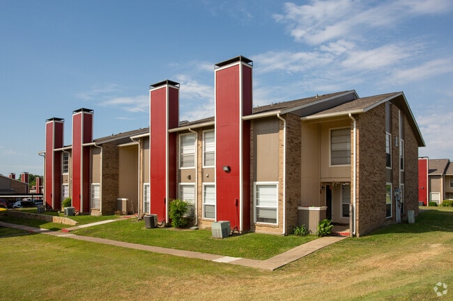
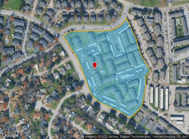
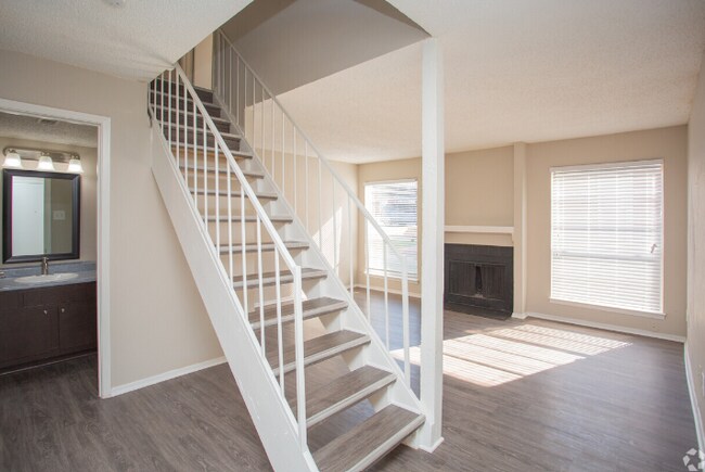
8950 N Normandale St
Dallas-Fort Worth-Arlington, TX
Western Hills Add Sec Iii-Viii
03433609
WESTERN HILLS ADD SEC III-VIII BLOCK 75 LOT AR1
Multifamilydwelling
Tarrant
X
Texas
48439C0280K
ar1
2024
13.10 AC
2025
Western Hills/Ridglea
105207
Dallas/Ft Worth
245,043 SF
DEMOGRAPHICS near 8950 N Normandale St
1 Mile
3 Mile
5 Mile
2024 Total Population
18,560
82,564
157,023
2029 Population
19,628
87,258
166,496
Pop Growth 2024-2029
+ 5.75%
+ 5.69%
+ 6.03%
Average Age
35
37
38
2024 Total Households
8,052
32,615
64,887
HH Growth 2024-2029
+ 5.76%
+ 5.76%
+ 6.22%
Median Household Inc
$32,721
$53,958
$62,562
Avg Household Size
2.20
2.50
2.30
2024 Avg HH Vehicles
1.00
2.00
2.00
Median Home Value
$225,112
$226,750
$267,088
Median Year Built
1981
1981
1982
Nearby Places
Map Layers
Map Styles
 Street
 Aerial
- Restaurants
- Banks
- Shops
- Fitness
- Groceries
PUBLIC TRANSPORTATION
COMMUTER RAIL
Texas And Pacific (T&P) (Trinity Railway Express - Dallas Area Rapid Transit (DART))
DRIVE
WALK
Distance
Texas And Pacific (T&P) (Trinity Railway Express - Dallas Area Rapid Transit (DART))
15 min
9.3 mi
Fort Worth (Heartland Flyer - Amtrak, Texas Eagle - Amtrak)
DRIVE
WALK
Distance
Fort Worth (Heartland Flyer - Amtrak, Texas Eagle - Amtrak)
15 min
9.7 mi
AIRPORT
Dallas-Fort Worth International
DRIVE
WALK
Distance
Dallas-Fort Worth International
45 min
35.4 mi
Freight Ports
Port of Shreveport
DRIVE
WALK
Distance
Port of Shreveport
257 min
238.2 mi
Nearby Properties
Address
Land Use
TOTAL SIZE
Lot Size
Zoning
Address
Land Use
TOTAL SIZE
Lot Size
Zoning
314,284 SF
26.29 AC
Address
Land Use
TOTAL SIZE
Lot Size
Zoning
242,244 SF
27.01 AC
Address
Land Use
TOTAL SIZE
Lot Size
Zoning
244,918 SF
15.52 AC
Address
Land Use
TOTAL SIZE
Lot Size
Zoning
209,682 SF
56.25 AC
Address
Land Use
TOTAL SIZE
Lot Size
Zoning
315,552 SF
14.84 AC
Address
Land Use
TOTAL SIZE
Lot Size
Zoning
352,999 SF
12.63 AC
Address
Land Use
TOTAL SIZE
Lot Size
Zoning
136,717 SF
12.07 AC
Address
Land Use
TOTAL SIZE
Lot Size
Zoning
284,418 SF
15.86 AC
Address
Land Use
TOTAL SIZE
Lot Size
Zoning
238,580 SF
11.56 AC
Address
Land Use
TOTAL SIZE
Lot Size
Zoning
222,000 SF
12 AC
Address
Land Use
TOTAL SIZE
Lot Size
Zoning
217,500 SF
7.34 AC
Address
Land Use
TOTAL SIZE
Lot Size
Zoning
321,124 SF
13.20 AC
Address
Land Use
TOTAL SIZE
Lot Size
Zoning
230,766 SF
9.24 AC
Address
Land Use
TOTAL SIZE
Lot Size
Zoning
186,818 SF
103.53 AC
Address
Land Use
TOTAL SIZE
Lot Size
Zoning
177,726 SF
8.15 AC
Address
Land Use
TOTAL SIZE
Lot Size
Zoning
104,831 SF
13.50 AC
Address
Land Use
TOTAL SIZE
Lot Size
Zoning
103,270 SF
13.01 AC
Address
Land Use
TOTAL SIZE
Lot Size
Zoning
95,481 SF
8.18 AC
Address
Land Use
TOTAL SIZE
Lot Size
Zoning
237,447 SF
12.95 AC
Address
Land Use
TOTAL SIZE
Lot Size
Zoning
161,746 SF
9.43 AC
Address
Land Use
TOTAL SIZE
Lot Size
Zoning
236,934 SF
51.75 AC
Address
Land Use
TOTAL SIZE
Lot Size
Zoning
179,340 SF
1.02 AC
Address
Land Use
TOTAL SIZE
Lot Size
Zoning
32,060 SF
34.15 AC
Address
Land Use
TOTAL SIZE
Lot Size
Zoning
60,842 SF
9.61 AC
Address
Land Use
TOTAL SIZE
Lot Size
Zoning
176,346 SF
7.78 AC
Address
Land Use
TOTAL SIZE
Lot Size
Zoning
194,922 SF
11.26 AC
Address
Land Use
TOTAL SIZE
Lot Size
Zoning
190,013 SF
11.24 AC
Address
Land Use
TOTAL SIZE
Lot Size
Zoning
142,328 SF
8.02 AC
Address
Land Use
TOTAL SIZE
Lot Size
Zoning
220,539 SF
10.86 AC
The World's #1 Commercial Real Estate Marketplace
Connect with us
© 2026 CoStar Group
The information above has been obtained from sources believed reliable. While we do not doubt its accuracy we have not verified it and make no guarantee, warranty or representation about it. It is your responsibility to independently confirm its accuracy and completeness. Any projections, opinions, assumptions, or estimates used are for example only and do not represent the current or future performance of the property. The value of this transaction to you depends on tax and other factors which should be evaluated by your tax, financial, and legal advisors. You and your advisors should conduct a careful, independent investigation of the property to determine to your satisfaction the suitability of the property for your needs.