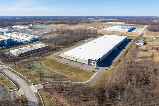
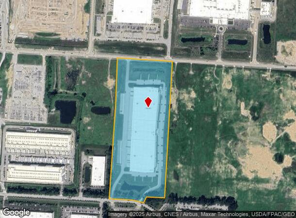
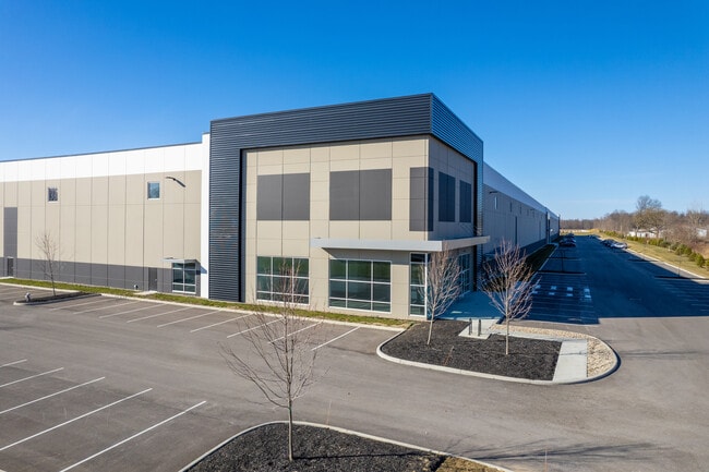
Property Record
8950 Smiths Mill Rd N, New Albany, OH 43054

NEARBY LISTINGS FOR SALE OR LEASE
Property Detail
8950 Smiths Mill Rd N
095-111498-00.001
25.766 AC LOT 18 R15 T2 Q2 TAX ABATE CRA 2022-2036 TIF 10-YR (2022 - 2031)
Assemblylightindustrial
Licking
X
Ohio
39089C0280J
18
2024
25.76 AC
2024
Licking County
755601
Columbus
315,599 SF
Columbus, OH
DEMOGRAPHICS near 8950 Smiths Mill Rd N
1 Mile
3 Mile
5 Mile
2024 Total Population
243
5,031
31,142
2029 Population
254
5,135
31,820
Pop Growth 2024-2029
+ 4.53%
+ 2.07%
+ 2.18%
Average Age
45
39
39
2024 Total Households
93
1,698
12,445
HH Growth 2024-2029
+ 4.30%
+ 2.36%
+ 2.02%
Median Household Inc
$157,927
$155,419
$116,431
Avg Household Size
2.60
2.90
2.50
2024 Avg HH Vehicles
3.00
2.00
2.00
Median Home Value
$350,000
$408,815
$387,357
Median Year Built
1984
1993
2001
Nearby Places
Map Layers
Map Styles
 Street
 Aerial
- Restaurants
- Banks
- Shops
- Fitness
- Groceries
PUBLIC TRANSPORTATION
AIRPORT
John Glenn Columbus International
DRIVE
WALK
Distance
John Glenn Columbus International
26 min
14.4 mi
Rickenbacker International
DRIVE
WALK
Distance
Rickenbacker International
41 min
27.2 mi
Freight Ports
Port of Toledo
DRIVE
WALK
Distance
Port of Toledo
187 min
149.9 mi
SALE & LEASE HISTORY
LISTING DATE
SALE/LEASE

May 22, 2025
For Lease
Mar 29, 2021
For Lease
Nearby Properties
Address
Land Use
TOTAL SIZE
Lot Size
Zoning
Address
Land Use
TOTAL SIZE
Lot Size
Zoning
46,000 SF
214.46 AC
Address
Land Use
TOTAL SIZE
Lot Size
Zoning
624,564 SF
104.45 AC
Address
Land Use
TOTAL SIZE
Lot Size
Zoning
159,232 SF
66.44 AC
Address
Land Use
TOTAL SIZE
Lot Size
Zoning
14,120 SF
92.69 AC
Address
Land Use
TOTAL SIZE
Lot Size
Zoning
772,217 SF
98.64 AC
Address
Land Use
TOTAL SIZE
Lot Size
Zoning
672,706 SF
222.09 AC
Address
Land Use
TOTAL SIZE
Lot Size
Zoning
271,758 SF
63.69 AC
Address
Land Use
TOTAL SIZE
Lot Size
Zoning
1,435,497 SF
234.05 AC
Address
Land Use
TOTAL SIZE
Lot Size
Zoning
163,020 SF
35 AC
Address
Land Use
TOTAL SIZE
Lot Size
Zoning
1,752 SF
512.98 AC
Address
Land Use
TOTAL SIZE
Lot Size
Zoning
122,941 SF
28.56 AC
Address
Land Use
TOTAL SIZE
Lot Size
Zoning
446,500 SF
37.26 AC
Address
Land Use
TOTAL SIZE
Lot Size
Zoning
279.62 AC
Address
Land Use
TOTAL SIZE
Lot Size
Zoning
454,348 SF
33.34 AC
Address
Land Use
TOTAL SIZE
Lot Size
Zoning
541,500 SF
41.30 AC
Address
Land Use
TOTAL SIZE
Lot Size
Zoning
173,661 SF
40.94 AC
Address
Land Use
TOTAL SIZE
Lot Size
Zoning
506,879 SF
142.43 AC
Address
Land Use
TOTAL SIZE
Lot Size
Zoning
524,527 SF
27.49 AC
Address
Land Use
TOTAL SIZE
Lot Size
Zoning
237.57 AC
Address
Land Use
TOTAL SIZE
Lot Size
Zoning
754,614 SF
63.55 AC
Address
Land Use
TOTAL SIZE
Lot Size
Zoning
217.82 AC
Address
Land Use
TOTAL SIZE
Lot Size
Zoning
250,496 SF
15.13 AC
Address
Land Use
TOTAL SIZE
Lot Size
Zoning
351,846 SF
33.05 AC
Address
Land Use
TOTAL SIZE
Lot Size
Zoning
1,469 SF
197.34 AC
Address
Land Use
TOTAL SIZE
Lot Size
Zoning
416,945 SF
15.01 AC
Address
Land Use
TOTAL SIZE
Lot Size
Zoning
372,683 SF
18.14 AC
Address
Land Use
TOTAL SIZE
Lot Size
Zoning
280,800 SF
18.07 AC
Address
Land Use
TOTAL SIZE
Lot Size
Zoning
322,252 SF
22.40 AC
Address
Land Use
TOTAL SIZE
Lot Size
Zoning
303,001 SF
21.34 AC
The World's #1 Commercial Real Estate Marketplace
Connect with us
© 2026 CoStar Group
The information above has been obtained from sources believed reliable. While we do not doubt its accuracy we have not verified it and make no guarantee, warranty or representation about it. It is your responsibility to independently confirm its accuracy and completeness. Any projections, opinions, assumptions, or estimates used are for example only and do not represent the current or future performance of the property. The value of this transaction to you depends on tax and other factors which should be evaluated by your tax, financial, and legal advisors. You and your advisors should conduct a careful, independent investigation of the property to determine to your satisfaction the suitability of the property for your needs.