Property Record
897 N Macarthur Blvd, Lewisville, TX 75067
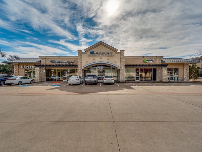

Property Detail
897 N Macarthur Blvd
Dallas-Fort Worth-Arlington, TX
VISTA POINT II BLK A LOT 4R2
R336436
DENTON
Commercialnec
Texas
2024
4
2025
1.37 AC
021740
Lewisville
9,648 SF
Dallas/Ft Worth
NEARBY LISTINGS FOR SALE OR LEASE
DEMOGRAPHICS near 897 N Macarthur Blvd
1 mile
3 mile
5 mile
2024 Total Population
15,843
93,221
245,979
2029 Population
17,854
103,277
276,970
Pop Growth 2024-2029
+ 12.69%
+ 10.79%
+ 12.60%
Average Age
38
37
37
2024 Total Households
6,574
37,156
93,665
HH Growth 2024-2029
+ 14.83%
+ 12.35%
+ 12.70%
Median Household Inc
$100,869
$87,345
$90,332
Avg Household Size
2.40
2.50
2.60
2024 Avg HH Vehicles
2.00
2.00
2.00
Median Home Value
$382,763
$390,042
$355,324
Median Year Built
1999
1994
1994
Nearby Places
Map Layers
Map Styles
 Street
 Aerial
Transit
 Traffic
 Biking
Places
Listings with unknown addresses are not visible on the map
- Restaurants
- Banks
- Shops
- Fitness
- Groceries
PUBLIC TRANSPORTATION
AIRPORT
Dallas-Fort Worth International
Drive
Walk
Distance
Dallas-Fort Worth International
13 min
10.1 mi
Dallas Love Field
Drive
Walk
Distance
Dallas Love Field
26 min
18.7 mi
Freight Ports
Port of Shreveport
Drive
Walk
Distance
Port of Shreveport
1 min
199.7 mi
SALE & LEASE HISTORY
LISTING DATE
SALE/LEASE

Sep 25, 2016
For Lease
Jan 21, 2022
For Sale
Aug 21, 2019
For Lease
Apr 03, 2025
For Sale
Apr 02, 2024
For Lease
Apr 02, 2024
For Sale
Nearby Properties
Address
Land Use
TOTAL SIZE
Lot Size
Zoning
Address
Land Use
TOTAL SIZE
Lot Size
Zoning
481,511 SF
34.76 AC
Z172
Address
Land Use
TOTAL SIZE
Lot Size
Zoning
1,065,080 SF
49.57 AC
Z123
Address
Land Use
TOTAL SIZE
Lot Size
Zoning
660,180 SF
29.95 AC
Address
Land Use
TOTAL SIZE
Lot Size
Zoning
462,692 SF
30.77 AC
2G
Address
Land Use
TOTAL SIZE
Lot Size
Zoning
835,344 SF
143.50 AC
Address
Land Use
TOTAL SIZE
Lot Size
Zoning
452,167 SF
5.80 AC
Address
Land Use
TOTAL SIZE
Lot Size
Zoning
242,707 SF
27.63 AC
Z343
Address
Land Use
TOTAL SIZE
Lot Size
Zoning
352,209 SF
17.54 AC
Z172
Address
Land Use
TOTAL SIZE
Lot Size
Zoning
394,048 SF
16.36 AC
Address
Land Use
TOTAL SIZE
Lot Size
Zoning
379,940 SF
63.48 AC
Z31
Address
Land Use
TOTAL SIZE
Lot Size
Zoning
382,330 SF
21.43 AC
3B
Address
Land Use
TOTAL SIZE
Lot Size
Zoning
385,247 SF
22.59 AC
3B
Address
Land Use
TOTAL SIZE
Lot Size
Zoning
344,868 SF
19.44 AC
Address
Land Use
TOTAL SIZE
Lot Size
Zoning
514,192 SF
21.56 AC
3B
Address
Land Use
TOTAL SIZE
Lot Size
Zoning
412,389 SF
16.69 AC
3B
Address
Land Use
TOTAL SIZE
Lot Size
Zoning
354,546 SF
19.38 AC
3B
Address
Land Use
TOTAL SIZE
Lot Size
Zoning
345,320 SF
20.50 AC
Z172
Address
Land Use
TOTAL SIZE
Lot Size
Zoning
947,236 SF
52.19 AC
Address
Land Use
TOTAL SIZE
Lot Size
Zoning
411,223 SF
24.07 AC
3B
Address
Land Use
TOTAL SIZE
Lot Size
Zoning
1,030,000 SF
53.43 AC
Address
Land Use
TOTAL SIZE
Lot Size
Zoning
344,926 SF
19.93 AC
3B
Address
Land Use
TOTAL SIZE
Lot Size
Zoning
347,181 SF
18.51 AC
3B
Address
Land Use
TOTAL SIZE
Lot Size
Zoning
714,010 SF
36.33 AC
Z31
Address
Land Use
TOTAL SIZE
Lot Size
Zoning
392,646 SF
19.65 AC
3B
Address
Land Use
TOTAL SIZE
Lot Size
Zoning
330,816 SF
14.97 AC
Address
Land Use
TOTAL SIZE
Lot Size
Zoning
310,788 SF
15.05 AC
Address
Land Use
TOTAL SIZE
Lot Size
Zoning
315,084 SF
13.76 AC
3B
Address
Land Use
TOTAL SIZE
Lot Size
Zoning
295,668 SF
13.03 AC
Address
Land Use
TOTAL SIZE
Lot Size
Zoning
659,218 SF
34.29 AC
Address
Land Use
TOTAL SIZE
Lot Size
Zoning
251,650 SF
14.22 AC
The World's #1 Commercial Real Estate Marketplace
Connect with us
© 2026 CoStar Group
The information above has been obtained from sources believed reliable. While we do not doubt its accuracy we have not verified it and make no guarantee, warranty or representation about it. It is your responsibility to independently confirm its accuracy and completeness. Any projections, opinions, assumptions, or estimates used are for example only and do not represent the current or future performance of the property. The value of this transaction to you depends on tax and other factors which should be evaluated by your tax, financial, and legal advisors. You and your advisors should conduct a careful, independent investigation of the property to determine to your satisfaction the suitability of the property for your needs.