Property Record
8970 Hammock Oak Dr, Naples, FL 34108
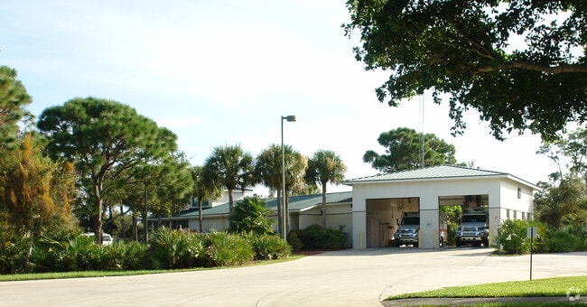

Property Detail
8970 Hammock Oak Dr
00176682006
33 48 25 UNREC PAR H & D DESC IN OR 1338 PG 50
Countyproperty
Collier
PUD
Florida
2024
3.63 AC
2025
North Naples
010208
Southwest Florida
11,289 SF
Naples-Marco Island, FL
NEARBY LISTINGS FOR SALE OR LEASE
-
-
View all Naples listings for sale on LoopNet.com
DEMOGRAPHICS near 8970 Hammock Oak Dr
1 mile
3 mile
5 mile
2025 Total Population
10,008
44,594
108,022
2030 Population
11,164
49,122
118,511
Pop Growth 2025-2030
+ 11.55%
+ 10.15%
+ 9.71%
Average Age
59
56
55
2025 Total Households
4,975
21,417
51,837
HH Growth 2025-2030
+ 11.10%
+ 9.77%
+ 9.34%
Median Household Inc
$114,838
$111,152
$102,818
Avg Household Size
1.90
2.00
2.00
2025 Avg HH Vehicles
2.00
2.00
2.00
Median Home Value
$935,973
$888,123
$802,305
Median Year Built
1992
1993
1994
Nearby Places
Map Layers
Map Styles
 Street
 Aerial
Layers
 Traffic
 Biking
Places
Listings with unknown addresses are not visible on the map
- Restaurants
- Banks
- Shops
- Fitness
- Groceries
PUBLIC TRANSPORTATION
AIRPORT
Southwest Florida International
Drive
Walk
Distance
Southwest Florida International
40 min
28.4 mi
Nearby Properties
Address
Land Use
TOTAL SIZE
Lot Size
Zoning
Address
Land Use
TOTAL SIZE
Lot Size
Zoning
770,104 SF
26.22 AC
PUD
Address
Land Use
TOTAL SIZE
Lot Size
Zoning
688,632 SF
29.28 AC
A
Address
Land Use
TOTAL SIZE
Lot Size
Zoning
735,070 SF
41.34 AC
A
Address
Land Use
TOTAL SIZE
Lot Size
Zoning
377,883 SF
20.34 AC
PUD
Address
Land Use
TOTAL SIZE
Lot Size
Zoning
906,730 SF
7.86 AC
Address
Land Use
TOTAL SIZE
Lot Size
Zoning
123,282 SF
6.50 AC
PUD
Address
Land Use
TOTAL SIZE
Lot Size
Zoning
398,094 SF
17.31 AC
A
Address
Land Use
TOTAL SIZE
Lot Size
Zoning
363,275 SF
21.02 AC
PUD
Address
Land Use
TOTAL SIZE
Lot Size
Zoning
292,967 SF
13.12 AC
PUD
Address
Land Use
TOTAL SIZE
Lot Size
Zoning
453,819 SF
4.53 AC
Address
Land Use
TOTAL SIZE
Lot Size
Zoning
87,499 SF
4.36 AC
Address
Land Use
TOTAL SIZE
Lot Size
Zoning
72,844 SF
15.94 AC
RSF-1
Address
Land Use
TOTAL SIZE
Lot Size
Zoning
10,831 SF
155 AC
RMF-16
Address
Land Use
TOTAL SIZE
Lot Size
Zoning
174,770 SF
3.65 AC
PUD
Address
Land Use
TOTAL SIZE
Lot Size
Zoning
82,382 SF
9.98 AC
PUD
Address
Land Use
TOTAL SIZE
Lot Size
Zoning
363,194 SF
2.51 AC
A
Address
Land Use
TOTAL SIZE
Lot Size
Zoning
181,774 SF
6.19 AC
PUD
Address
Land Use
TOTAL SIZE
Lot Size
Zoning
155,918 SF
27.31 AC
PUD
Address
Land Use
TOTAL SIZE
Lot Size
Zoning
134,551 SF
19.50 AC
PUD
Address
Land Use
TOTAL SIZE
Lot Size
Zoning
145,061 SF
18.82 AC
PUD
Address
Land Use
TOTAL SIZE
Lot Size
Zoning
164,004 SF
2.66 AC
Address
Land Use
TOTAL SIZE
Lot Size
Zoning
133,302 SF
3.82 AC
NAPLES
Address
Land Use
TOTAL SIZE
Lot Size
Zoning
174,365 SF
18.56 AC
PUD
Address
Land Use
TOTAL SIZE
Lot Size
Zoning
206,687 SF
19.85 AC
PUD
Address
Land Use
TOTAL SIZE
Lot Size
Zoning
139,947 SF
4.99 AC
PUD
Address
Land Use
TOTAL SIZE
Lot Size
Zoning
223,844 SF
27.55 AC
PUD
Address
Land Use
TOTAL SIZE
Lot Size
Zoning
112,623 SF
13.10 AC
PUD
Address
Land Use
TOTAL SIZE
Lot Size
Zoning
4.95 AC
C-3
Address
Land Use
TOTAL SIZE
Lot Size
Zoning
161,531 SF
18.72 AC
PUD
Address
Land Use
TOTAL SIZE
Lot Size
Zoning
60,211 SF
2.62 AC
RT
The World's #1 Commercial Real Estate Marketplace
Connect with us
© 2026 CoStar Group
The information above has been obtained from sources believed reliable. While we do not doubt its accuracy we have not verified it and make no guarantee, warranty or representation about it. It is your responsibility to independently confirm its accuracy and completeness. Any projections, opinions, assumptions, or estimates used are for example only and do not represent the current or future performance of the property. The value of this transaction to you depends on tax and other factors which should be evaluated by your tax, financial, and legal advisors. You and your advisors should conduct a careful, independent investigation of the property to determine to your satisfaction the suitability of the property for your needs.