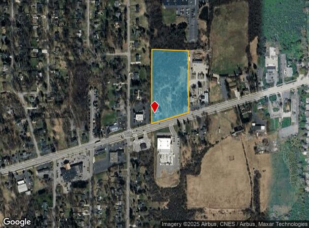
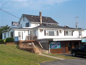
Property Record
8970 Main St, Clarence, NY 14031

NEARBY LISTINGS FOR SALE OR LEASE
Property Detail
8970 Main St
143200 70.20-3-28.1
Erie
Commercialofficeresidentialmixeduse
New York
X
28.100
36029C0233H
7.37 AC
2025
Outlying Erie County
2024
Buffalo/Niagara Falls
014601
Buffalo-Cheektowaga, NY
3,051 SF
DEMOGRAPHICS near 8970 Main St
1 Mile
3 Mile
5 Mile
2024 Total Population
2,917
33,422
110,820
2029 Population
2,902
33,584
110,797
Pop Growth 2024-2029
(0.51%)
+ 0.48%
(0.02%)
Average Age
43
44
44
2024 Total Households
1,206
13,446
46,187
HH Growth 2024-2029
(0.58%)
+ 0.42%
(0.11%)
Median Household Inc
$87,988
$97,883
$88,866
Avg Household Size
2.40
2.40
2.30
2024 Avg HH Vehicles
2.00
2.00
2.00
Median Home Value
$258,842
$296,681
$268,025
Median Year Built
1963
1987
1973
Nearby Places
Map Layers
Map Styles
 Street
 Aerial
- Restaurants
- Banks
- Shops
- Fitness
- Groceries
PUBLIC TRANSPORTATION
COMMUTER RAIL
DRIVE
WALK
Distance
14 min
7.2 mi
DRIVE
WALK
Distance
15 min
7.7 mi
AIRPORT
Buffalo Niagara International
DRIVE
WALK
Distance
Buffalo Niagara International
10 min
5.0 mi
Niagara Falls International
DRIVE
WALK
Distance
Niagara Falls International
35 min
20.3 mi
Nearby Properties
Address
Land Use
TOTAL SIZE
Lot Size
Zoning
Address
Land Use
TOTAL SIZE
Lot Size
Zoning
868,362 SF
135.20 AC
Address
Land Use
TOTAL SIZE
Lot Size
Zoning
24,600 SF
19.20 AC
00000
Address
Land Use
TOTAL SIZE
Lot Size
Zoning
176,108 SF
20.04 AC
GB
Address
Land Use
TOTAL SIZE
Lot Size
Zoning
260,326 SF
22.70 AC
Address
Land Use
TOTAL SIZE
Lot Size
Zoning
203,546 SF
13.55 AC
Address
Land Use
TOTAL SIZE
Lot Size
Zoning
12,576 SF
18.15 AC
Address
Land Use
TOTAL SIZE
Lot Size
Zoning
2,173 SF
15.33 AC
Address
Land Use
TOTAL SIZE
Lot Size
Zoning
8,296 SF
16.60 AC
Address
Land Use
TOTAL SIZE
Lot Size
Zoning
196,113 SF
21.09 AC
Address
Land Use
TOTAL SIZE
Lot Size
Zoning
54,109 SF
6.19 AC
OB
Address
Land Use
TOTAL SIZE
Lot Size
Zoning
19,558 SF
11.07 AC
Address
Land Use
TOTAL SIZE
Lot Size
Zoning
19,640 SF
13.34 AC
00000
Address
Land Use
TOTAL SIZE
Lot Size
Zoning
11,439 SF
6.64 AC
Address
Land Use
TOTAL SIZE
Lot Size
Zoning
320,945 SF
62.80 AC
RES
Address
Land Use
TOTAL SIZE
Lot Size
Zoning
108,824 SF
9.34 AC
Address
Land Use
TOTAL SIZE
Lot Size
Zoning
8,347 SF
14.04 AC
Address
Land Use
TOTAL SIZE
Lot Size
Zoning
5,912 SF
8.35 AC
Address
Land Use
TOTAL SIZE
Lot Size
Zoning
119,982 SF
8.35 AC
Address
Land Use
TOTAL SIZE
Lot Size
Zoning
206,912 SF
26.41 AC
Address
Land Use
TOTAL SIZE
Lot Size
Zoning
144,171 SF
17.40 AC
Address
Land Use
TOTAL SIZE
Lot Size
Zoning
134,702 SF
10.70 AC
00000
Address
Land Use
TOTAL SIZE
Lot Size
Zoning
28,823 SF
0.66 AC
Address
Land Use
TOTAL SIZE
Lot Size
Zoning
113,828 SF
9.04 AC
Address
Land Use
TOTAL SIZE
Lot Size
Zoning
71,739 SF
7.58 AC
Address
Land Use
TOTAL SIZE
Lot Size
Zoning
60,268 SF
5 AC
Address
Land Use
TOTAL SIZE
Lot Size
Zoning
110,712 SF
17.80 AC
Address
Land Use
TOTAL SIZE
Lot Size
Zoning
115,179 SF
8.80 AC
OB
Address
Land Use
TOTAL SIZE
Lot Size
Zoning
121,766 SF
9.82 AC
GB
Address
Land Use
TOTAL SIZE
Lot Size
Zoning
64,710 SF
6.22 AC
Address
Land Use
TOTAL SIZE
Lot Size
Zoning
96,118 SF
8.14 AC
GB
The World's #1 Commercial Real Estate Marketplace
Connect with us
© 2026 CoStar Group
The information above has been obtained from sources believed reliable. While we do not doubt its accuracy we have not verified it and make no guarantee, warranty or representation about it. It is your responsibility to independently confirm its accuracy and completeness. Any projections, opinions, assumptions, or estimates used are for example only and do not represent the current or future performance of the property. The value of this transaction to you depends on tax and other factors which should be evaluated by your tax, financial, and legal advisors. You and your advisors should conduct a careful, independent investigation of the property to determine to your satisfaction the suitability of the property for your needs.