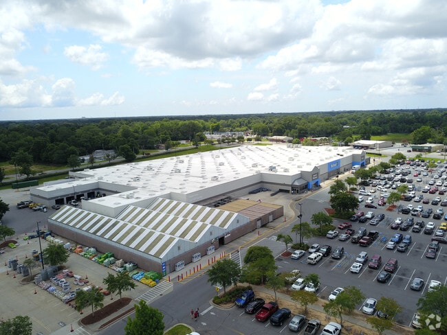
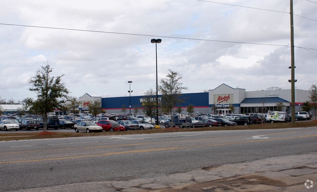
Property Record
8970 Pensacola Blvd, Pensacola, FL 32534

NEARBY LISTINGS FOR SALE OR LEASE
Property Detail
8970 Pensacola Blvd
Pensacola-Ferry Pass-Brent, FL
Final Plat Of Ensley Wal-Mart
11-1S-30-1500-000-010
LT 1 FINAL PLAT OF ENSLEY WAL-MART PB 17 P 56 OR 2521 P 78 OR 4361/4398 P 1366/1724 OR 6447 P 1927 LESS OR 5068 P 328 WAL-MART STORES EAST INC
Departmentstore
Escambia
X
Florida
12033C0295G
1
0
18.71 AC
2025
Ensley/N Brent
003400
Pensacola
219,541 SF
DEMOGRAPHICS near 8970 Pensacola Blvd
1 Mile
3 Mile
5 Mile
2024 Total Population
5,204
45,481
110,280
2029 Population
5,362
46,283
112,005
Pop Growth 2024-2029
+ 3.04%
+ 1.76%
+ 1.56%
Average Age
38
40
40
2024 Total Households
2,114
19,088
43,617
HH Growth 2024-2029
+ 2.98%
+ 1.79%
+ 1.55%
Median Household Inc
$45,808
$54,793
$55,559
Avg Household Size
2.30
2.30
2.30
2024 Avg HH Vehicles
1.00
2.00
2.00
Median Home Value
$114,068
$186,657
$198,787
Median Year Built
1988
1987
1986
Nearby Places
Map Layers
Map Styles
 Street
 Aerial
- Restaurants
- Banks
- Shops
- Fitness
- Groceries
PUBLIC TRANSPORTATION
AIRPORT
Pensacola International
DRIVE
WALK
Distance
Pensacola International
18 min
8.8 mi
Freight Ports
Port of Mobile
DRIVE
WALK
Distance
Port of Mobile
59 min
50.1 mi
Nearby Properties
Address
Land Use
TOTAL SIZE
Lot Size
Zoning
Address
Land Use
TOTAL SIZE
Lot Size
Zoning
368,851 SF
19.16 AC
HDMU,REC
Address
Land Use
TOTAL SIZE
Lot Size
Zoning
336,376 SF
19.68 AC
HDMU
Address
Land Use
TOTAL SIZE
Lot Size
Zoning
266,096 SF
13.46 AC
HDMU
Address
Land Use
TOTAL SIZE
Lot Size
Zoning
274,822 SF
12.67 AC
HC/LI
Address
Land Use
TOTAL SIZE
Lot Size
Zoning
295,911 SF
15.53 AC
HC/LI,HDR
Address
Land Use
TOTAL SIZE
Lot Size
Zoning
264,273 SF
15.97 AC
HC/LI
Address
Land Use
TOTAL SIZE
Lot Size
Zoning
303,273 SF
9.95 AC
HC/LI
Address
Land Use
TOTAL SIZE
Lot Size
Zoning
269,404 SF
23.85 AC
HDMU
Address
Land Use
TOTAL SIZE
Lot Size
Zoning
263,838 SF
9.03 AC
HC/LI
Address
Land Use
TOTAL SIZE
Lot Size
Zoning
265,012 SF
14.51 AC
HC/LI
Address
Land Use
TOTAL SIZE
Lot Size
Zoning
238,060 SF
21.93 AC
HDMU
Address
Land Use
TOTAL SIZE
Lot Size
Zoning
262,823 SF
11.57 AC
HDMU
Address
Land Use
TOTAL SIZE
Lot Size
Zoning
175,834 SF
14.17 AC
COM
Address
Land Use
TOTAL SIZE
Lot Size
Zoning
94,378 SF
11.56 AC
HC/LI
Address
Land Use
TOTAL SIZE
Lot Size
Zoning
109,855 SF
16.70 AC
COM
Address
Land Use
TOTAL SIZE
Lot Size
Zoning
176,462 SF
9.51 AC
HDR
Address
Land Use
TOTAL SIZE
Lot Size
Zoning
106,507 SF
12.71 AC
HDMU
Address
Land Use
TOTAL SIZE
Lot Size
Zoning
87,454 SF
2.27 AC
HDMU
Address
Land Use
TOTAL SIZE
Lot Size
Zoning
99,164 SF
9.67 AC
HDMU
Address
Land Use
TOTAL SIZE
Lot Size
Zoning
131,408 SF
21.67 AC
HC/LI
Address
Land Use
TOTAL SIZE
Lot Size
Zoning
160,211 SF
34 AC
HDMU
Address
Land Use
TOTAL SIZE
Lot Size
Zoning
84,372 SF
3.94 AC
HC/LI,HDMU
Address
Land Use
TOTAL SIZE
Lot Size
Zoning
72,248 SF
6.07 AC
COM,HC/LI
Address
Land Use
TOTAL SIZE
Lot Size
Zoning
169,842 SF
8.03 AC
HDMU
Address
Land Use
TOTAL SIZE
Lot Size
Zoning
258,979 SF
100 AC
PUB
Address
Land Use
TOTAL SIZE
Lot Size
Zoning
203,306 SF
64.76 AC
MDR
Address
Land Use
TOTAL SIZE
Lot Size
Zoning
151,363 SF
12.17 AC
HC/LI
Address
Land Use
TOTAL SIZE
Lot Size
Zoning
31,457 SF
7.09 AC
HC/LI
Address
Land Use
TOTAL SIZE
Lot Size
Zoning
96,306 SF
10.23 AC
COM
The World's #1 Commercial Real Estate Marketplace
Connect with us
© 2026 CoStar Group
The information above has been obtained from sources believed reliable. While we do not doubt its accuracy we have not verified it and make no guarantee, warranty or representation about it. It is your responsibility to independently confirm its accuracy and completeness. Any projections, opinions, assumptions, or estimates used are for example only and do not represent the current or future performance of the property. The value of this transaction to you depends on tax and other factors which should be evaluated by your tax, financial, and legal advisors. You and your advisors should conduct a careful, independent investigation of the property to determine to your satisfaction the suitability of the property for your needs.