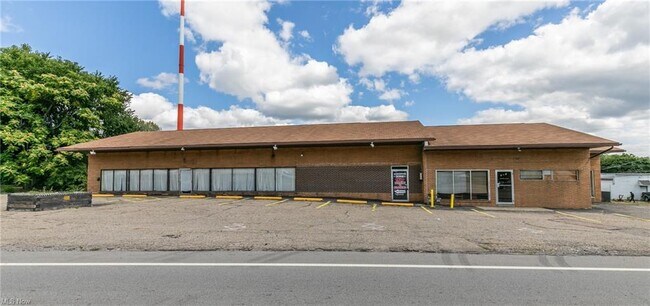
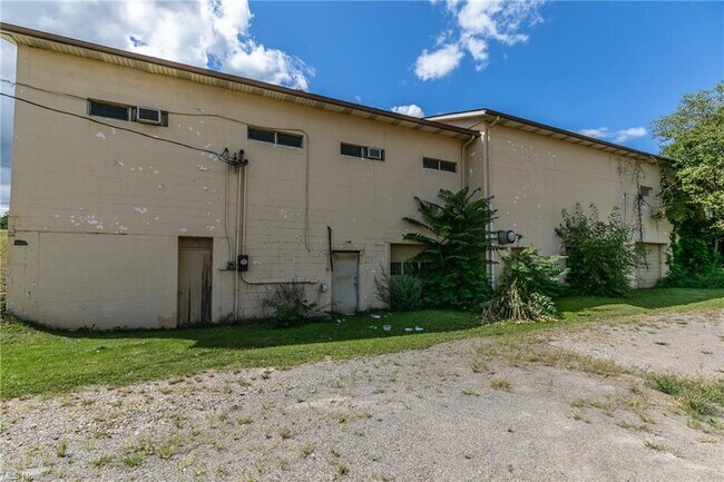
Property Record
899 Canton Rd, Akron, OH 44312

Property Detail
899 Canton Rd
51-10659
TR 7 E OF CANTON RD & PT OF OLD GREENTOWN TRANS LINE LESS PT FOR RD 1-WD
Commercialnec
Summit
B and X Area of moderate flood hazard, usually the area between the limits of the 100-year and 500-year floods.
Ohio
2023
1.06 AC
2025
Akron
503702
Cleveland
10,048 SF
Akron, OH
NEARBY LISTINGS FOR SALE OR LEASE
DEMOGRAPHICS near 899 Canton Rd
1 mile
3 mile
5 mile
2025 Total Population
8,805
50,922
133,782
2030 Population
8,823
50,911
134,184
Pop Growth 2025-2030
+ 0.20%
(0.02%)
+ 0.30%
Average Age
44
42
40
2025 Total Households
4,014
22,199
56,176
HH Growth 2025-2030
+ 0.17%
(0.05%)
+ 0.28%
Median Household Inc
$57,512
$58,428
$56,668
Avg Household Size
2.10
2.30
2.30
2025 Avg HH Vehicles
2.00
2.00
2.00
Median Home Value
$148,896
$148,240
$154,414
Median Year Built
1962
1958
1959
Nearby Places
Map Layers
Map Styles
 Street
 Aerial
Transit
 Traffic
 Biking
Places
Listings with unknown addresses are not visible on the map
- Restaurants
- Banks
- Shops
- Fitness
- Groceries
PUBLIC TRANSPORTATION
COMMUTER RAIL
Drive
Walk
Distance
14 min
7.0 mi
AIRPORT
Akron-Canton Regional
Drive
Walk
Distance
Akron-Canton Regional
20 min
11.6 mi
Cleveland-Hopkins International
Drive
Walk
Distance
Cleveland-Hopkins International
66 min
46.8 mi
SALE & LEASE HISTORY
LISTING DATE
SALE/LEASE

Mar 30, 2025
For Sale
Mar 20, 2024
For Sale
Jan 20, 2023
For Sale
Jan 12, 2022
For Sale
Nearby Properties
Address
Land Use
TOTAL SIZE
Lot Size
Zoning
Address
Land Use
TOTAL SIZE
Lot Size
Zoning
Address
Land Use
TOTAL SIZE
Lot Size
Zoning
162,774 SF
16.58 AC
Address
Land Use
TOTAL SIZE
Lot Size
Zoning
264,753 SF
22.87 AC
Address
Land Use
TOTAL SIZE
Lot Size
Zoning
Address
Land Use
TOTAL SIZE
Lot Size
Zoning
Address
Land Use
TOTAL SIZE
Lot Size
Zoning
245,911 SF
14.48 AC
Address
Land Use
TOTAL SIZE
Lot Size
Zoning
142,848 SF
13.85 AC
Address
Land Use
TOTAL SIZE
Lot Size
Zoning
639,478 SF
29.51 AC
Address
Land Use
TOTAL SIZE
Lot Size
Zoning
Address
Land Use
TOTAL SIZE
Lot Size
Zoning
270,860 SF
131.89 AC
Address
Land Use
TOTAL SIZE
Lot Size
Zoning
115,586 SF
4.93 AC
Address
Land Use
TOTAL SIZE
Lot Size
Zoning
374,370 SF
27.79 AC
Address
Land Use
TOTAL SIZE
Lot Size
Zoning
56,529 SF
3.67 AC
Address
Land Use
TOTAL SIZE
Lot Size
Zoning
203,059 SF
55.62 AC
Address
Land Use
TOTAL SIZE
Lot Size
Zoning
489,909 SF
23.77 AC
Address
Land Use
TOTAL SIZE
Lot Size
Zoning
5,863 SF
343.43 AC
Address
Land Use
TOTAL SIZE
Lot Size
Zoning
882,093 SF
50.96 AC
Address
Land Use
TOTAL SIZE
Lot Size
Zoning
68,979 SF
5.07 AC
Address
Land Use
TOTAL SIZE
Lot Size
Zoning
65,350 SF
9.99 AC
Address
Land Use
TOTAL SIZE
Lot Size
Zoning
124,939 SF
13.89 AC
Address
Land Use
TOTAL SIZE
Lot Size
Zoning
667,050 SF
24.55 AC
Address
Land Use
TOTAL SIZE
Lot Size
Zoning
187,454 SF
12.59 AC
Address
Land Use
TOTAL SIZE
Lot Size
Zoning
243,424 SF
13.24 AC
Address
Land Use
TOTAL SIZE
Lot Size
Zoning
55,072 SF
3.41 AC
Address
Land Use
TOTAL SIZE
Lot Size
Zoning
58,910 SF
3.15 AC
Address
Land Use
TOTAL SIZE
Lot Size
Zoning
97,454 SF
3.14 AC
Address
Land Use
TOTAL SIZE
Lot Size
Zoning
235,498 SF
21.41 AC
Address
Land Use
TOTAL SIZE
Lot Size
Zoning
141,342 SF
6.34 AC
Address
Land Use
TOTAL SIZE
Lot Size
Zoning
60,276 SF
11.81 AC
Address
Land Use
TOTAL SIZE
Lot Size
Zoning
538,000 SF
21.51 AC
The World's #1 Commercial Real Estate Marketplace
Connect with us
© 2026 CoStar Group
The information above has been obtained from sources believed reliable. While we do not doubt its accuracy we have not verified it and make no guarantee, warranty or representation about it. It is your responsibility to independently confirm its accuracy and completeness. Any projections, opinions, assumptions, or estimates used are for example only and do not represent the current or future performance of the property. The value of this transaction to you depends on tax and other factors which should be evaluated by your tax, financial, and legal advisors. You and your advisors should conduct a careful, independent investigation of the property to determine to your satisfaction the suitability of the property for your needs.