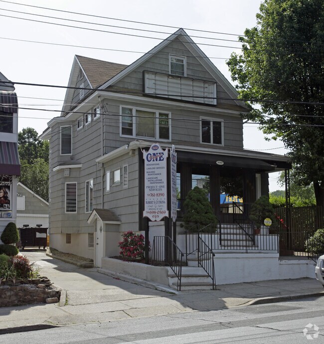
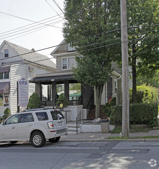
Property Record
899 Manor Rd, Staten Island, NY 10314

Property Detail
899 Manor Rd
00701-0006
Richmond
Commercialofficeresidentialmixeduse
New York
R3-1
6
B and X Area of moderate flood hazard, usually the area between the limits of the 100-year and 500-year floods.
0.09 AC
2025
Staten Island
2026
Long Island (New York)
017300
New York-Jersey City-White Plains, NY-NJ
1,344 SF
NEARBY LISTINGS FOR SALE OR LEASE
DEMOGRAPHICS near 899 Manor Rd
1 mile
3 mile
5 mile
2025 Total Population
30,515
316,506
521,624
2030 Population
30,872
318,911
528,318
Pop Growth 2025-2030
+ 1.17%
+ 0.76%
+ 1.28%
Average Age
42
41
41
2025 Total Households
10,210
108,462
186,642
HH Growth 2025-2030
+ 1.03%
+ 0.77%
+ 1.36%
Median Household Inc
$106,575
$91,292
$89,931
Avg Household Size
2.80
2.80
2.70
2025 Avg HH Vehicles
2.00
1.00
1.00
Median Home Value
$753,360
$718,639
$704,421
Median Year Built
1966
1968
1967
Nearby Places
Map Layers
Map Styles
 Street
 Aerial
Layers
 Traffic
 Biking
Places
Listings with unknown addresses are not visible on the map
- Restaurants
- Banks
- Shops
- Fitness
- Groceries
PUBLIC TRANSPORTATION
COMMUTER RAIL
Dongan Hills (Staten Island Railway - New York MTA Subway (The Subway))
Drive
Walk
Distance
Dongan Hills (Staten Island Railway - New York MTA Subway (The Subway))
8 min
2.2 mi
Grant City (Staten Island Railway - New York MTA Subway (The Subway))
Drive
Walk
Distance
Grant City (Staten Island Railway - New York MTA Subway (The Subway))
8 min
2.7 mi
AIRPORT
Newark Liberty International
Drive
Walk
Distance
Newark Liberty International
22 min
13.9 mi
LaGuardia
Drive
Walk
Distance
LaGuardia
38 min
22.7 mi
John F Kennedy International
Drive
Walk
Distance
John F Kennedy International
38 min
25.4 mi
Freight Ports
New York Container Terminal
Drive
Walk
Distance
New York Container Terminal
9 min
4.7 mi
Nearby Properties
Address
Land Use
TOTAL SIZE
Lot Size
Zoning
Address
Land Use
TOTAL SIZE
Lot Size
Zoning
3,600 SF
731.18 AC
PARK
Address
Land Use
TOTAL SIZE
Lot Size
Zoning
633,280 SF
202.90 AC
R3-2
Address
Land Use
TOTAL SIZE
Lot Size
Zoning
738,600 SF
189.62 AC
R3-2
Address
Land Use
TOTAL SIZE
Lot Size
Zoning
1,258,042 SF
14.47 AC
C4-1
Address
Land Use
TOTAL SIZE
Lot Size
Zoning
640,077 SF
19.34 AC
R3-1
Address
Land Use
TOTAL SIZE
Lot Size
Zoning
566,000 SF
103.31 AC
R3-2
Address
Land Use
TOTAL SIZE
Lot Size
Zoning
135,000 SF
117.71 AC
PARK
Address
Land Use
TOTAL SIZE
Lot Size
Zoning
310,560 SF
15.90 AC
C4-1
Address
Land Use
TOTAL SIZE
Lot Size
Zoning
538,240 SF
12.08 AC
R2
Address
Land Use
TOTAL SIZE
Lot Size
Zoning
494,840 SF
34.77 AC
R3-2
Address
Land Use
TOTAL SIZE
Lot Size
Zoning
195,395 SF
12.04 AC
R3-2
Address
Land Use
TOTAL SIZE
Lot Size
Zoning
521,405 SF
52.79 AC
R3-1
Address
Land Use
TOTAL SIZE
Lot Size
Zoning
418,012 SF
6.74 AC
R3-1
Address
Land Use
TOTAL SIZE
Lot Size
Zoning
421,275 SF
18.95 AC
R3-2
Address
Land Use
TOTAL SIZE
Lot Size
Zoning
111,000 SF
186.03 AC
PARK
Address
Land Use
TOTAL SIZE
Lot Size
Zoning
294,320 SF
15 AC
R3-2
Address
Land Use
TOTAL SIZE
Lot Size
Zoning
183,839 SF
9.74 AC
PARK
Address
Land Use
TOTAL SIZE
Lot Size
Zoning
240 SF
47.41 AC
R3-2
Address
Land Use
TOTAL SIZE
Lot Size
Zoning
476,145 SF
50.97 AC
R3-1
Address
Land Use
TOTAL SIZE
Lot Size
Zoning
48,500 SF
61.98 AC
R3-2
Address
Land Use
TOTAL SIZE
Lot Size
Zoning
226,590 SF
5.52 AC
R3-2
Address
Land Use
TOTAL SIZE
Lot Size
Zoning
66.37 AC
PARK
Address
Land Use
TOTAL SIZE
Lot Size
Zoning
146,855 SF
16.50 AC
R3-1
Address
Land Use
TOTAL SIZE
Lot Size
Zoning
84,160 SF
81.12 AC
M1-1
Address
Land Use
TOTAL SIZE
Lot Size
Zoning
77,502 SF
1.29 AC
R3-1
Address
Land Use
TOTAL SIZE
Lot Size
Zoning
900 SF
50 AC
R1-1
Address
Land Use
TOTAL SIZE
Lot Size
Zoning
319,000 SF
18.76 AC
C4-1
Address
Land Use
TOTAL SIZE
Lot Size
Zoning
654,030 SF
13.94 AC
R5
Address
Land Use
TOTAL SIZE
Lot Size
Zoning
288,456 SF
2.30 AC
M3-1
Address
Land Use
TOTAL SIZE
Lot Size
Zoning
151,637 SF
7.41 AC
C4-1
The World's #1 Commercial Real Estate Marketplace
Connect with us
© 2026 CoStar Group
The information above has been obtained from sources believed reliable. While we do not doubt its accuracy we have not verified it and make no guarantee, warranty or representation about it. It is your responsibility to independently confirm its accuracy and completeness. Any projections, opinions, assumptions, or estimates used are for example only and do not represent the current or future performance of the property. The value of this transaction to you depends on tax and other factors which should be evaluated by your tax, financial, and legal advisors. You and your advisors should conduct a careful, independent investigation of the property to determine to your satisfaction the suitability of the property for your needs.