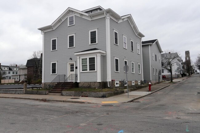
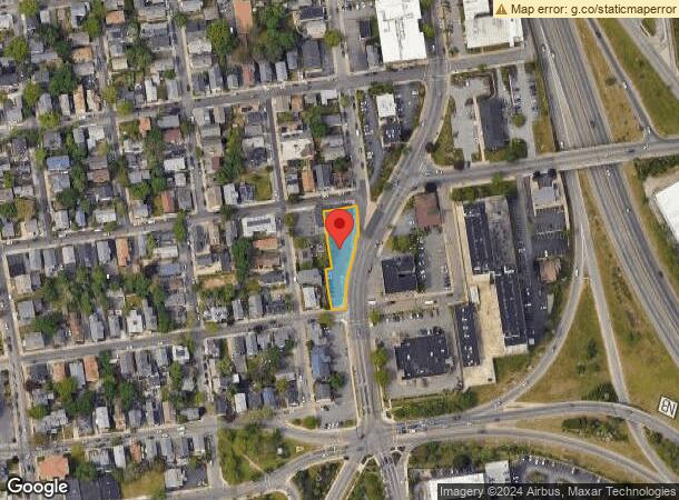
Property Record
899 Pleasant St, New Bedford, MA 02740
Current Lease Availabilities
NEARBY LISTINGS FOR SALE OR LEASE
Property Detail
899 Pleasant St
NEWB-000058-000000-000302
Bristol
Medicalbuilding
Massachusetts
X
302
25005C0393G
0.41 AC
2025
Attleboro/New Bedford
2025
Boston
651300
Providence-Warwick, RI-MA
7,400 SF
DEMOGRAPHICS near 899 Pleasant St
1 Mile
3 Mile
5 Mile
2024 Total Population
22,940
102,720
134,711
2029 Population
22,221
100,408
132,363
Pop Growth 2024-2029
(3.13%)
(2.25%)
(1.74%)
Average Age
40
40
41
2024 Total Households
9,939
42,790
55,515
HH Growth 2024-2029
(3.15%)
(2.30%)
(1.79%)
Median Household Inc
$39,415
$49,799
$57,331
Avg Household Size
2.20
2.30
2.30
2024 Avg HH Vehicles
1.00
1.00
2.00
Median Home Value
$274,280
$321,946
$346,225
Median Year Built
1946
1948
1949
Nearby Places
Map Layers
Map Styles
 Street
 Aerial
- Restaurants
- Banks
- Shops
- Fitness
- Groceries
PUBLIC TRANSPORTATION
AIRPORT
Rhode Island Tf Green International
DRIVE
WALK
Distance
Rhode Island Tf Green International
53 min
37.4 mi
Freight Ports
Port of New Bedford Harbor
DRIVE
WALK
Distance
Port of New Bedford Harbor
2 min
0.7 mi
Nearby Properties
Address
Land Use
TOTAL SIZE
Lot Size
Zoning
Address
Land Use
TOTAL SIZE
Lot Size
Zoning
10.29 AC
RA
Address
Land Use
TOTAL SIZE
Lot Size
Zoning
23.71 AC
RA
Address
Land Use
TOTAL SIZE
Lot Size
Zoning
252,482 SF
11.56 AC
RA
Address
Land Use
TOTAL SIZE
Lot Size
Zoning
243,052 SF
9.66 AC
RB
Address
Land Use
TOTAL SIZE
Lot Size
Zoning
228,726 SF
5.51 AC
MUB
Address
Land Use
TOTAL SIZE
Lot Size
Zoning
61.86 AC
I
Address
Land Use
TOTAL SIZE
Lot Size
Zoning
269,020 SF
2.26 AC
MUB
Address
Land Use
TOTAL SIZE
Lot Size
Zoning
74.70 AC
SRA
Address
Land Use
TOTAL SIZE
Lot Size
Zoning
40.65 AC
GB
Address
Land Use
TOTAL SIZE
Lot Size
Zoning
194,474 SF
11.57 AC
RA
Address
Land Use
TOTAL SIZE
Lot Size
Zoning
231,634 SF
2.45 AC
IB
Address
Land Use
TOTAL SIZE
Lot Size
Zoning
284,742 SF
17.14 AC
RB
Address
Land Use
TOTAL SIZE
Lot Size
Zoning
160,391 SF
2.86 AC
MUB
Address
Land Use
TOTAL SIZE
Lot Size
Zoning
27.48 AC
B
Address
Land Use
TOTAL SIZE
Lot Size
Zoning
214,698 SF
4.66 AC
IB
Address
Land Use
TOTAL SIZE
Lot Size
Zoning
24.95 AC
PB
Address
Land Use
TOTAL SIZE
Lot Size
Zoning
127,514 SF
4.23 AC
MUB
Address
Land Use
TOTAL SIZE
Lot Size
Zoning
11.67 AC
RC
Address
Land Use
TOTAL SIZE
Lot Size
Zoning
188,739 SF
2.57 AC
IB
Address
Land Use
TOTAL SIZE
Lot Size
Zoning
5,716 SF
35.18 AC
GR
Address
Land Use
TOTAL SIZE
Lot Size
Zoning
134,355 SF
2.21 AC
IB
Address
Land Use
TOTAL SIZE
Lot Size
Zoning
5.59 AC
RC
Address
Land Use
TOTAL SIZE
Lot Size
Zoning
183,450 SF
2.51 AC
RA
Address
Land Use
TOTAL SIZE
Lot Size
Zoning
183,196 SF
8.14 AC
MUB
Address
Land Use
TOTAL SIZE
Lot Size
Zoning
146,081 SF
2.15 AC
MUB
Address
Land Use
TOTAL SIZE
Lot Size
Zoning
111,337 SF
11.30 AC
RB
Address
Land Use
TOTAL SIZE
Lot Size
Zoning
147,850 SF
2.50 AC
RC
Address
Land Use
TOTAL SIZE
Lot Size
Zoning
119,865 SF
3.22 AC
IA
Address
Land Use
TOTAL SIZE
Lot Size
Zoning
130,060 SF
18.34 AC
SRA
Address
Land Use
TOTAL SIZE
Lot Size
Zoning
212,875 SF
7.24 AC
WI
The World's #1 Commercial Real Estate Marketplace
Connect with us
© 2025 CoStar Group
The information above has been obtained from sources believed reliable. While we do not doubt its accuracy we have not verified it and make no guarantee, warranty or representation about it. It is your responsibility to independently confirm its accuracy and completeness. Any projections, opinions, assumptions, or estimates used are for example only and do not represent the current or future performance of the property. The value of this transaction to you depends on tax and other factors which should be evaluated by your tax, financial, and legal advisors. You and your advisors should conduct a careful, independent investigation of the property to determine to your satisfaction the suitability of the property for your needs.