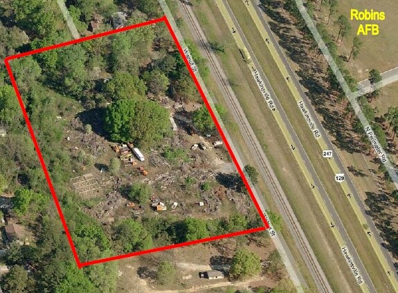
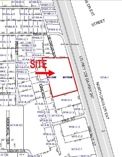
Property Record
899 Walnut St, Warner Robins, GA 31093

Property Detail
899 Walnut St
Warner Robins, GA
LOTS 7, 8, 9, & 10 J O JACOBS
0W18AE007000
HOUSTON
Industrialacreage
Georgia
M1
7-10
B and X Area of moderate flood hazard, usually the area between the limits of the 100-year and 500-year floods.
6 AC
2025
Perry/Warner Robins
2025
Other Market Areas
020301
NEARBY LISTINGS FOR SALE OR LEASE
DEMOGRAPHICS near 899 Walnut St
1 mile
3 mile
5 mile
2025 Total Population
5,158
31,919
65,708
2030 Population
5,528
33,751
69,260
Pop Growth 2025-2030
+ 7.17%
+ 5.74%
+ 5.41%
Average Age
36
37
38
2025 Total Households
2,033
12,568
26,323
HH Growth 2025-2030
+ 7.48%
+ 5.82%
+ 5.45%
Median Household Inc
$28,922
$47,231
$54,626
Avg Household Size
2.40
2.40
2.40
2025 Avg HH Vehicles
1.00
2.00
2.00
Median Home Value
$62,888
$119,150
$146,744
Median Year Built
1965
1973
1979
Nearby Places
Map Layers
Map Styles
 Street
 Aerial
Layers
 Traffic
 Biking
Places
Listings with unknown addresses are not visible on the map
- Restaurants
- Banks
- Shops
- Fitness
- Groceries
Nearby Properties
Address
Land Use
TOTAL SIZE
Lot Size
Zoning
Address
Land Use
TOTAL SIZE
Lot Size
Zoning
88,965 SF
18.72 AC
R2
Address
Land Use
TOTAL SIZE
Lot Size
Zoning
11,658 SF
30.23 AC
R2
Address
Land Use
TOTAL SIZE
Lot Size
Zoning
304,246 SF
23.11 AC
C2
Address
Land Use
TOTAL SIZE
Lot Size
Zoning
164,700 SF
19.20 AC
R3
Address
Land Use
TOTAL SIZE
Lot Size
Zoning
178,400 SF
49.03 AC
R2
Address
Land Use
TOTAL SIZE
Lot Size
Zoning
1,531 SF
27.16 AC
R4
Address
Land Use
TOTAL SIZE
Lot Size
Zoning
40,284 SF
3.74 AC
C3
Address
Land Use
TOTAL SIZE
Lot Size
Zoning
25,062 SF
R4
Address
Land Use
TOTAL SIZE
Lot Size
Zoning
25,062 SF
R4
Address
Land Use
TOTAL SIZE
Lot Size
Zoning
3,906 SF
12.53 AC
C2
Address
Land Use
TOTAL SIZE
Lot Size
Zoning
61,628 SF
45 AC
C2
Address
Land Use
TOTAL SIZE
Lot Size
Zoning
94,798 SF
8.17 AC
R2
Address
Land Use
TOTAL SIZE
Lot Size
Zoning
11,200 SF
7.60 AC
R4
Address
Land Use
TOTAL SIZE
Lot Size
Zoning
3,375 SF
13.72 AC
R4
Address
Land Use
TOTAL SIZE
Lot Size
Zoning
10,296 SF
16.21 AC
R4
Address
Land Use
TOTAL SIZE
Lot Size
Zoning
5,220 SF
8.66 AC
C2
Address
Land Use
TOTAL SIZE
Lot Size
Zoning
1,512 SF
309.01 AC
M2
Address
Land Use
TOTAL SIZE
Lot Size
Zoning
71,434 SF
10.58 AC
R2
Address
Land Use
TOTAL SIZE
Lot Size
Zoning
128,540 SF
32.26 AC
R2
Address
Land Use
TOTAL SIZE
Lot Size
Zoning
75,613 SF
11.51 AC
C1
Address
Land Use
TOTAL SIZE
Lot Size
Zoning
90,000 SF
12 AC
R1
Address
Land Use
TOTAL SIZE
Lot Size
Zoning
48,924 SF
7.73 AC
C2
Address
Land Use
TOTAL SIZE
Lot Size
Zoning
60,000 SF
8.95 AC
C3
Address
Land Use
TOTAL SIZE
Lot Size
Zoning
43,247 SF
5.24 AC
C2
Address
Land Use
TOTAL SIZE
Lot Size
Zoning
4,234 SF
8.30 AC
R4
Address
Land Use
TOTAL SIZE
Lot Size
Zoning
3,264 SF
18.35 AC
R4
Address
Land Use
TOTAL SIZE
Lot Size
Zoning
45,888 SF
6.97 AC
C3
Address
Land Use
TOTAL SIZE
Lot Size
Zoning
42,100 SF
5.92 AC
C2
Address
Land Use
TOTAL SIZE
Lot Size
Zoning
120,000 SF
19.03 AC
R3
Address
Land Use
TOTAL SIZE
Lot Size
Zoning
121,500 SF
10 AC
R2
The World's #1 Commercial Real Estate Marketplace
Connect with us
© 2026 CoStar Group
The information above has been obtained from sources believed reliable. While we do not doubt its accuracy we have not verified it and make no guarantee, warranty or representation about it. It is your responsibility to independently confirm its accuracy and completeness. Any projections, opinions, assumptions, or estimates used are for example only and do not represent the current or future performance of the property. The value of this transaction to you depends on tax and other factors which should be evaluated by your tax, financial, and legal advisors. You and your advisors should conduct a careful, independent investigation of the property to determine to your satisfaction the suitability of the property for your needs.