Property Record
8Th St, Yuma, AZ 85365

Property Detail
8Th St
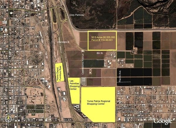
180-22-017
SECTION: 22 TOWNSHIP: 08S RANGE: 23W S2 SE4 EXC W 25 ACRES & EXC CO 8TH R/W PER 997/609, 973/576 AKA PARCEL B PEACH LOT SPLIT BK 24 PG 34
Municipalproperty
Yuma
X
Arizona
04027C1530F
50.50 AC
0
Yuma & El Centro
2025
Other Market Areas
011107
Yuma, AZ
4,611 SF
NEARBY LISTINGS FOR SALE OR LEASE
DEMOGRAPHICS near 8Th St
1 mile
3 mile
5 mile
2024 Total Population
280
45,510
92,714
2029 Population
300
49,412
100,170
Pop Growth 2024-2029
+ 7.14%
+ 8.57%
+ 8.04%
Average Age
37
37
37
2024 Total Households
101
17,161
33,004
HH Growth 2024-2029
+ 7.92%
+ 9.17%
+ 8.45%
Median Household Inc
$44,499
$47,005
$52,909
Avg Household Size
2.80
2.50
2.70
2024 Avg HH Vehicles
2.00
2.00
2.00
Median Home Value
$169,999
$141,909
$162,906
Median Year Built
1982
1977
1984
Nearby Places
Map Layers
Map Styles
 Street
 Aerial
Transit
 Traffic
 Biking
Places
Listings with unknown addresses are not visible on the map
- Restaurants
- Banks
- Shops
- Fitness
- Groceries
PUBLIC TRANSPORTATION
COMMUTER RAIL
Yuma Amtrak (Sunset Limited - Amtrak, Texas Eagle - Amtrak)
Drive
Walk
Distance
Yuma Amtrak (Sunset Limited - Amtrak, Texas Eagle - Amtrak)
3 min
1.5 mi
AIRPORT
Yuma International
Drive
Walk
Distance
Yuma International
12 min
5.5 mi
Freight Ports
Port of San Diego
Drive
Walk
Distance
Port of San Diego
192 min
172.0 mi
Nearby Properties
Address
Land Use
TOTAL SIZE
Lot Size
Zoning
Address
Land Use
TOTAL SIZE
Lot Size
Zoning
159,906 SF
3.19 AC
OT
Address
Land Use
TOTAL SIZE
Lot Size
Zoning
197,031 SF
28.76 AC
B-2
Address
Land Use
TOTAL SIZE
Lot Size
Zoning
112,343 SF
3.13 AC
OT
Address
Land Use
TOTAL SIZE
Lot Size
Zoning
206,107 SF
21.96 AC
B-2
Address
Land Use
TOTAL SIZE
Lot Size
Zoning
107,310 SF
4.37 AC
OT
Address
Land Use
TOTAL SIZE
Lot Size
Zoning
61,000 SF
36.50 AC
B-2
Address
Land Use
TOTAL SIZE
Lot Size
Zoning
42,529 SF
1.28 AC
OT
Address
Land Use
TOTAL SIZE
Lot Size
Zoning
407,940 SF
24.04 AC
HI
Address
Land Use
TOTAL SIZE
Lot Size
Zoning
62,393 SF
2.83 AC
OT
Address
Land Use
TOTAL SIZE
Lot Size
Zoning
119,714 SF
6.75 AC
C-2
Address
Land Use
TOTAL SIZE
Lot Size
Zoning
95,263 SF
5.46 AC
B-2
Address
Land Use
TOTAL SIZE
Lot Size
Zoning
114,420 SF
6.13 AC
B-2
Address
Land Use
TOTAL SIZE
Lot Size
Zoning
50,918 SF
3.85 AC
TR
Address
Land Use
TOTAL SIZE
Lot Size
Zoning
141,161 SF
11.18 AC
B-2
Address
Land Use
TOTAL SIZE
Lot Size
Zoning
77,301 SF
2.25 AC
B-2
Address
Land Use
TOTAL SIZE
Lot Size
Zoning
132,480 SF
23.73 AC
LI
Address
Land Use
TOTAL SIZE
Lot Size
Zoning
68,961 SF
3.23 AC
B-2
Address
Land Use
TOTAL SIZE
Lot Size
Zoning
157,234 SF
5.71 AC
R-1-6
Address
Land Use
TOTAL SIZE
Lot Size
Zoning
66,490 SF
2.85 AC
Address
Land Use
TOTAL SIZE
Lot Size
Zoning
168,098 SF
8.77 AC
R-3
Address
Land Use
TOTAL SIZE
Lot Size
Zoning
33,765 SF
2.81 AC
B-2
Address
Land Use
TOTAL SIZE
Lot Size
Zoning
18.80 AC
Address
Land Use
TOTAL SIZE
Lot Size
Zoning
302,392 SF
16.80 AC
R-3
Address
Land Use
TOTAL SIZE
Lot Size
Zoning
133,196 SF
14.75 AC
B-2
Address
Land Use
TOTAL SIZE
Lot Size
Zoning
90,280 SF
2.98 AC
B-2
Address
Land Use
TOTAL SIZE
Lot Size
Zoning
96,278 SF
9.71 AC
B-1
Address
Land Use
TOTAL SIZE
Lot Size
Zoning
56,885 SF
22.05 AC
R-1-6
Address
Land Use
TOTAL SIZE
Lot Size
Zoning
69,315 SF
22.47 AC
LI
Address
Land Use
TOTAL SIZE
Lot Size
Zoning
55,103 SF
4.55 AC
B-2
The World's #1 Commercial Real Estate Marketplace
Connect with us
© 2026 CoStar Group
The information above has been obtained from sources believed reliable. While we do not doubt its accuracy we have not verified it and make no guarantee, warranty or representation about it. It is your responsibility to independently confirm its accuracy and completeness. Any projections, opinions, assumptions, or estimates used are for example only and do not represent the current or future performance of the property. The value of this transaction to you depends on tax and other factors which should be evaluated by your tax, financial, and legal advisors. You and your advisors should conduct a careful, independent investigation of the property to determine to your satisfaction the suitability of the property for your needs.