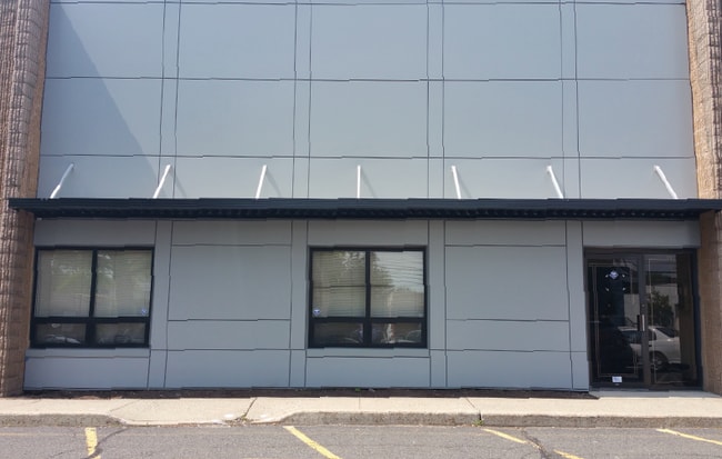
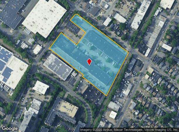
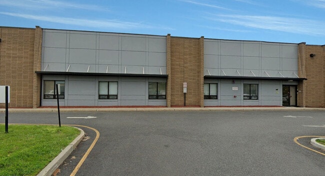
Property Record
244 W Forest Ave, Englewood, NJ 07631
Current Lease Availabilities
NEARBY LISTINGS FOR SALE OR LEASE
Property Detail
244 W Forest Ave
New York-Jersey City-White Plains, NY-NJ
J Levinson Prop
15-02509-0000-00001-01
6.51 AC IRG 2 BLDG
Commercialnec
Bergen
AE
New Jersey
34003C0213H
1.1
2024
6.51 AC
2025
Englewood/Edgewater
015401
Northern New Jersey
67,500 SF
DEMOGRAPHICS near 244 W Forest Ave
1 Mile
3 Mile
5 Mile
2024 Total Population
20,870
179,952
1,113,087
2029 Population
20,795
179,140
1,065,409
Pop Growth 2024-2029
(0.36%)
(0.45%)
(4.28%)
Average Age
40
42
40
2024 Total Households
7,843
66,531
412,258
HH Growth 2024-2029
(0.40%)
(0.38%)
(4.53%)
Median Household Inc
$91,488
$103,066
$61,478
Avg Household Size
2.60
2.60
2.60
2024 Avg HH Vehicles
2.00
2.00
1.00
Median Home Value
$449,023
$482,652
$478,728
Median Year Built
1968
1958
1951
Nearby Places
- Restaurants
- Banks
- Shops
- Fitness
- Groceries
PUBLIC TRANSPORTATION
COMMUTER RAIL
New Bridge Landing (Pascack Valley Line - NJ Transit Commuter Rail (NJ Transit))
DRIVE
WALK
Distance
New Bridge Landing (Pascack Valley Line - NJ Transit Commuter Rail (NJ Transit))
6 min
4.0 mi
Spuyten Duyvil Station (Hudson Line - Metro-North Commuter Railroad Company (Metro-North))
DRIVE
WALK
Distance
Spuyten Duyvil Station (Hudson Line - Metro-North Commuter Railroad Company (Metro-North))
16 min
8.4 mi
AIRPORT
LaGuardia
DRIVE
WALK
Distance
LaGuardia
25 min
14.2 mi
Newark Liberty International
DRIVE
WALK
Distance
Newark Liberty International
23 min
18.3 mi
Westchester County
DRIVE
WALK
Distance
Westchester County
46 min
30.0 mi
Freight Ports
NY - Red Hook Container Terminal
DRIVE
WALK
Distance
NY - Red Hook Container Terminal
37 min
20.6 mi
Nearby Properties
Address
Land Use
TOTAL SIZE
Lot Size
Zoning
Address
Land Use
TOTAL SIZE
Lot Size
Zoning
111.37 AC
P1
Address
Land Use
TOTAL SIZE
Lot Size
Zoning
24.08 AC
B2-A
Address
Land Use
TOTAL SIZE
Lot Size
Zoning
4.87 AC
R11
Address
Land Use
TOTAL SIZE
Lot Size
Zoning
512,862 SF
14.16 AC
Address
Land Use
TOTAL SIZE
Lot Size
Zoning
Address
Land Use
TOTAL SIZE
Lot Size
Zoning
72 AC
P1
Address
Land Use
TOTAL SIZE
Lot Size
Zoning
2.61 AC
D5
Address
Land Use
TOTAL SIZE
Lot Size
Zoning
572,137 SF
14.11 AC
R-D
Address
Land Use
TOTAL SIZE
Lot Size
Zoning
20.07 AC
H
Address
Land Use
TOTAL SIZE
Lot Size
Zoning
74,550 SF
11.28 AC
OI
Address
Land Use
TOTAL SIZE
Lot Size
Zoning
219.71 AC
O
Address
Land Use
TOTAL SIZE
Lot Size
Zoning
42.68 AC
P1
Address
Land Use
TOTAL SIZE
Lot Size
Zoning
13.09 AC
C3
Address
Land Use
TOTAL SIZE
Lot Size
Zoning
2 AC
R11
Address
Land Use
TOTAL SIZE
Lot Size
Zoning
100,151 SF
22.13 AC
B2
Address
Land Use
TOTAL SIZE
Lot Size
Zoning
2.55 AC
D5
Address
Land Use
TOTAL SIZE
Lot Size
Zoning
39 AC
P1
Address
Land Use
TOTAL SIZE
Lot Size
Zoning
5.87 AC
R10
Address
Land Use
TOTAL SIZE
Lot Size
Zoning
5.22 AC
APT
Address
Land Use
TOTAL SIZE
Lot Size
Zoning
4.89 AC
R10
Address
Land Use
TOTAL SIZE
Lot Size
Zoning
43.65 AC
PARK
Address
Land Use
TOTAL SIZE
Lot Size
Zoning
4.54 AC
R-M3
Address
Land Use
TOTAL SIZE
Lot Size
Zoning
1.68 AC
R11
Address
Land Use
TOTAL SIZE
Lot Size
Zoning
2.55 AC
RC-1
Address
Land Use
TOTAL SIZE
Lot Size
Zoning
32 AC
P1
Address
Land Use
TOTAL SIZE
Lot Size
Zoning
4.75 AC
R9
Address
Land Use
TOTAL SIZE
Lot Size
Zoning
303,434 SF
13.34 AC
Address
Land Use
TOTAL SIZE
Lot Size
Zoning
15.76 AC
B2
Address
Land Use
TOTAL SIZE
Lot Size
Zoning
2.92 AC
RC-2
Address
Land Use
TOTAL SIZE
Lot Size
Zoning
5.53 AC
RS
The World's #1 Commercial Real Estate Marketplace
Connect with us
© 2025 CoStar Group
The information above has been obtained from sources believed reliable. While we do not doubt its accuracy we have not verified it and make no guarantee, warranty or representation about it. It is your responsibility to independently confirm its accuracy and completeness. Any projections, opinions, assumptions, or estimates used are for example only and do not represent the current or future performance of the property. The value of this transaction to you depends on tax and other factors which should be evaluated by your tax, financial, and legal advisors. You and your advisors should conduct a careful, independent investigation of the property to determine to your satisfaction the suitability of the property for your needs.