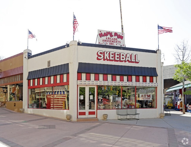
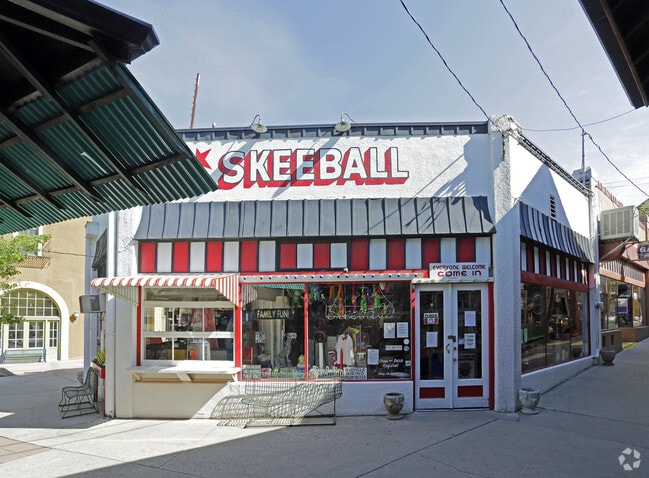
Property Record
9 Arcade, Manitou Springs, CO 80829

Property Detail
9 Arcade
74053-43-017
PART OF LOT 37 BLK A MANITOU SPGS AS FOLS, BEG AT A PT ON THE NELY LN OF MANITOU AVE, SD PT BEING SELY COR OF THAT CERT TR DES IN BK 2004-702, TH N 32<28 E 37.54 FT FOR THE POB, TH N 32<28 E 84.68 FT, TH S 47<46 E 71.00 FT, TH S 40<40 W 61.80 FT, TH
Commercialbuilding
EL PASO
DWTN
Colorado
AE The base floodplain where base flood elevations are provided. AE Zones are now used on new format FIRMs instead of A1-A30 Zones.
37
2025
0.11 AC
2026
Southwest
006702
Colorado Springs
1,668 SF
Colorado Springs, CO
NEARBY LISTINGS FOR SALE OR LEASE
DEMOGRAPHICS near 9 Arcade
1 mile
3 mile
5 mile
2025 Total Population
3,016
12,587
53,753
2030 Population
3,077
12,836
54,902
Pop Growth 2025-2030
+ 2.02%
+ 1.98%
+ 2.14%
Average Age
44
47
44
2025 Total Households
1,591
6,134
24,990
HH Growth 2025-2030
+ 2.39%
+ 2.31%
+ 2.42%
Median Household Inc
$74,350
$82,907
$80,544
Avg Household Size
1.90
2.00
2.10
2025 Avg HH Vehicles
2.00
2.00
2.00
Median Home Value
$604,077
$581,293
$541,801
Median Year Built
1947
1966
1980
Nearby Places
Map Layers
Map Styles
 Street
 Aerial
Layers
 Traffic
 Biking
Places
Listings with unknown addresses are not visible on the map
- Restaurants
- Banks
- Shops
- Fitness
- Groceries
PUBLIC TRANSPORTATION
AIRPORT
City of Colorado Springs Municipal
Drive
Walk
Distance
City of Colorado Springs Municipal
32 min
16.7 mi
Freight Ports
Tulsa Port Of Catoosa
Drive
Walk
Distance
Tulsa Port Of Catoosa
755 min
700.7 mi
Nearby Properties
Address
Land Use
TOTAL SIZE
Lot Size
Zoning
Address
Land Use
TOTAL SIZE
Lot Size
Zoning
75,349 SF
27.75 AC
EPC
Address
Land Use
TOTAL SIZE
Lot Size
Zoning
45,268 SF
8.37 AC
PDZ UV
Address
Land Use
TOTAL SIZE
Lot Size
Zoning
4.78 AC
R-T
Address
Land Use
TOTAL SIZE
Lot Size
Zoning
2,422 SF
616.19 AC
PK MX-I PD
Address
Land Use
TOTAL SIZE
Lot Size
Zoning
20,147 SF
38.98 AC
PK HS
Address
Land Use
TOTAL SIZE
Lot Size
Zoning
127.25 AC
PK HS
Address
Land Use
TOTAL SIZE
Lot Size
Zoning
34,296 SF
0.85 AC
Address
Land Use
TOTAL SIZE
Lot Size
Zoning
3,058 SF
28.22 AC
HLDR
Address
Land Use
TOTAL SIZE
Lot Size
Zoning
6,658 SF
189.56 AC
R-E PK HS
Address
Land Use
TOTAL SIZE
Lot Size
Zoning
4,062 SF
355.88 AC
PK HS
Address
Land Use
TOTAL SIZE
Lot Size
Zoning
15,964 SF
6.04 AC
R-2 HS CU
Address
Land Use
TOTAL SIZE
Lot Size
Zoning
24,433 SF
1.69 AC
R-1 6
Address
Land Use
TOTAL SIZE
Lot Size
Zoning
925 SF
3.55 AC
R-T
Address
Land Use
TOTAL SIZE
Lot Size
Zoning
38,885 SF
5.82 AC
R-1 6
Address
Land Use
TOTAL SIZE
Lot Size
Zoning
171.67 AC
PK
Address
Land Use
TOTAL SIZE
Lot Size
Zoning
50.72 AC
PK HS
Address
Land Use
TOTAL SIZE
Lot Size
Zoning
122.07 AC
PK
Address
Land Use
TOTAL SIZE
Lot Size
Zoning
6,899 SF
2.77 AC
R-2 HS CU
Address
Land Use
TOTAL SIZE
Lot Size
Zoning
7,364 SF
0.34 AC
C
Address
Land Use
TOTAL SIZE
Lot Size
Zoning
21,989 SF
0.79 AC
Address
Land Use
TOTAL SIZE
Lot Size
Zoning
625 SF
2.42 AC
GR
Address
Land Use
TOTAL SIZE
Lot Size
Zoning
30,532 SF
17.08 AC
GR
Address
Land Use
TOTAL SIZE
Lot Size
Zoning
14,248 SF
0.93 AC
C
Address
Land Use
TOTAL SIZE
Lot Size
Zoning
11,452 SF
2.12 AC
R-5 HS
Address
Land Use
TOTAL SIZE
Lot Size
Zoning
72,616 SF
4.79 AC
BP HS CU
Address
Land Use
TOTAL SIZE
Lot Size
Zoning
254 SF
4.74 AC
Address
Land Use
TOTAL SIZE
Lot Size
Zoning
54,398 SF
1.20 AC
Address
Land Use
TOTAL SIZE
Lot Size
Zoning
625 SF
0.37 AC
R-E HS
Address
Land Use
TOTAL SIZE
Lot Size
Zoning
36,745 SF
0.95 AC
Address
Land Use
TOTAL SIZE
Lot Size
Zoning
8,272 SF
0.85 AC
R-1 6 CU
The World's #1 Commercial Real Estate Marketplace
Connect with us
© 2026 CoStar Group
The information above has been obtained from sources believed reliable. While we do not doubt its accuracy we have not verified it and make no guarantee, warranty or representation about it. It is your responsibility to independently confirm its accuracy and completeness. Any projections, opinions, assumptions, or estimates used are for example only and do not represent the current or future performance of the property. The value of this transaction to you depends on tax and other factors which should be evaluated by your tax, financial, and legal advisors. You and your advisors should conduct a careful, independent investigation of the property to determine to your satisfaction the suitability of the property for your needs.