Property Record
9 Brooklyn Ave, New Hyde Park, NY 11040
NEARBY LISTINGS FOR SALE OR LEASE
Property Detail
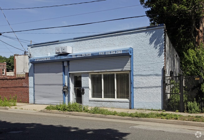
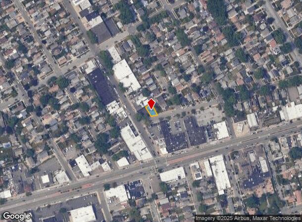
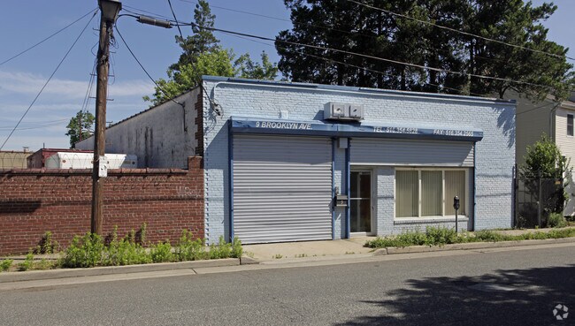
9 Brooklyn Ave
Nassau County-Suffolk County, NY
Map Of East Floral Park Situate In The T
2227-08-031-00-0058-0
TOWN #2 SCH DIST 005
Warehouse
Nassau
X
New York
36059C0205G
58
2025
0.07 AC
2025
Western Nassau
303000
Long Island (New York)
2,503 SF
DEMOGRAPHICS near 9 Brooklyn Ave
1 Mile
3 Mile
5 Mile
2024 Total Population
36,741
253,839
719,645
2029 Population
35,483
242,862
688,350
Pop Growth 2024-2029
(3.42%)
(4.32%)
(4.35%)
Average Age
43
43
42
2024 Total Households
12,079
83,109
234,052
HH Growth 2024-2029
(3.66%)
(4.56%)
(4.59%)
Median Household Inc
$131,819
$116,084
$108,419
Avg Household Size
3.00
3.00
3.00
2024 Avg HH Vehicles
2.00
2.00
2.00
Median Home Value
$733,889
$701,912
$700,817
Median Year Built
1948
1951
1951
Nearby Places
- Restaurants
- Banks
- Shops
- Fitness
- Groceries
PUBLIC TRANSPORTATION
COMMUTER RAIL
New Hyde Park Station (Port Jefferson Branch - Long Island Rail Road)
DRIVE
WALK
Distance
New Hyde Park Station (Port Jefferson Branch - Long Island Rail Road)
2 min
20 min
0.9 mi
Floral Park Station (Hempstead Branch - Long Island Rail Road)
DRIVE
WALK
Distance
Floral Park Station (Hempstead Branch - Long Island Rail Road)
2 min
19 min
1.0 mi
AIRPORT
John F Kennedy International
DRIVE
WALK
Distance
John F Kennedy International
19 min
11.0 mi
LaGuardia
DRIVE
WALK
Distance
LaGuardia
21 min
12.6 mi
Westchester County
DRIVE
WALK
Distance
Westchester County
50 min
34.0 mi
Freight Ports
NY - Red Hook Container Terminal
DRIVE
WALK
Distance
NY - Red Hook Container Terminal
33 min
20.7 mi
Nearby Properties
Address
Land Use
TOTAL SIZE
Lot Size
Zoning
Address
Land Use
TOTAL SIZE
Lot Size
Zoning
7,975 SF
133 AC
PARK
Address
Land Use
TOTAL SIZE
Lot Size
Zoning
1,667,567 SF
30 AC
R3-2
Address
Land Use
TOTAL SIZE
Lot Size
Zoning
986,724 SF
89.79 AC
R3-2
Address
Land Use
TOTAL SIZE
Lot Size
Zoning
800 SF
104.61 AC
PARK
Address
Land Use
TOTAL SIZE
Lot Size
Zoning
202,459 SF
82.16 AC
R3-2
Address
Land Use
TOTAL SIZE
Lot Size
Zoning
448,500 SF
22.59 AC
R3-2
Address
Land Use
TOTAL SIZE
Lot Size
Zoning
636,219 SF
11.39 AC
R3-2
Address
Land Use
TOTAL SIZE
Lot Size
Zoning
900 SF
86.35 AC
PARK
Address
Land Use
TOTAL SIZE
Lot Size
Zoning
1,800 SF
54.60 AC
PARK
Address
Land Use
TOTAL SIZE
Lot Size
Zoning
201,770 SF
7.09 AC
R3-2
Address
Land Use
TOTAL SIZE
Lot Size
Zoning
268,500 SF
27.50 AC
R4
Address
Land Use
TOTAL SIZE
Lot Size
Zoning
32,000 SF
50 AC
PARK
Address
Land Use
TOTAL SIZE
Lot Size
Zoning
344,292 SF
12.56 AC
R4
Address
Land Use
TOTAL SIZE
Lot Size
Zoning
7,030 SF
12.43 AC
R3-2
Address
Land Use
TOTAL SIZE
Lot Size
Zoning
111,122 SF
8.94 AC
R3-2
Address
Land Use
TOTAL SIZE
Lot Size
Zoning
123,832 SF
5.29 AC
R3-2
Address
Land Use
TOTAL SIZE
Lot Size
Zoning
231,865 SF
9.99 AC
C4-1
Address
Land Use
TOTAL SIZE
Lot Size
Zoning
356,093 SF
3 AC
R3-2
Address
Land Use
TOTAL SIZE
Lot Size
Zoning
171,000 SF
2.76 AC
R2A
Address
Land Use
TOTAL SIZE
Lot Size
Zoning
99,814 SF
1.31 AC
R3-2
Address
Land Use
TOTAL SIZE
Lot Size
Zoning
142,000 SF
2.38 AC
R3-2
Address
Land Use
TOTAL SIZE
Lot Size
Zoning
161,500 SF
3.44 AC
R3-2
Address
Land Use
TOTAL SIZE
Lot Size
Zoning
224,106 SF
6.72 AC
M1-1
Address
Land Use
TOTAL SIZE
Lot Size
Zoning
170,000 SF
4.02 AC
R3-2
Address
Land Use
TOTAL SIZE
Lot Size
Zoning
43,190 SF
6.64 AC
R3-2
Address
Land Use
TOTAL SIZE
Lot Size
Zoning
114,000 SF
4.36 AC
R3-2
Address
Land Use
TOTAL SIZE
Lot Size
Zoning
243,883 SF
3.51 AC
R6A
Address
Land Use
TOTAL SIZE
Lot Size
Zoning
155,000 SF
2.09 AC
R3A
Address
Land Use
TOTAL SIZE
Lot Size
Zoning
38,014 SF
1.29 AC
M1-1
Address
Land Use
TOTAL SIZE
Lot Size
Zoning
1,020 SF
12.33 AC
R3-2
The World's #1 Commercial Real Estate Marketplace
Connect with us
© 2025 CoStar Group
The information above has been obtained from sources believed reliable. While we do not doubt its accuracy we have not verified it and make no guarantee, warranty or representation about it. It is your responsibility to independently confirm its accuracy and completeness. Any projections, opinions, assumptions, or estimates used are for example only and do not represent the current or future performance of the property. The value of this transaction to you depends on tax and other factors which should be evaluated by your tax, financial, and legal advisors. You and your advisors should conduct a careful, independent investigation of the property to determine to your satisfaction the suitability of the property for your needs.