Property Record
9 Capper Dr, Pacific, MO 63069


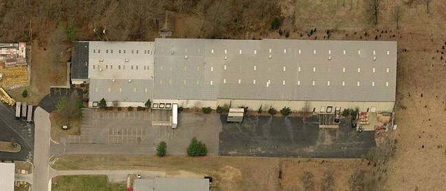

Property Detail
9 Capper Dr
19-6-230-0-099-008000
PEPPERPT NE COR NW NE
Realpropertynec
Franklin
B and X Area of moderate flood hazard, usually the area between the limits of the 100-year and 500-year floods.
Missouri
2025
6 AC
2025
Franklin County
800703
St. Louis
95,560 SF
St. Louis, MO-IL
NEARBY LISTINGS FOR SALE OR LEASE
DEMOGRAPHICS near 9 Capper Dr
1 mile
3 mile
5 mile
2025 Total Population
1,350
10,498
17,164
2030 Population
1,403
10,739
17,523
Pop Growth 2025-2030
+ 3.93%
+ 2.30%
+ 2.09%
Average Age
40
42
42
2025 Total Households
536
4,318
6,823
HH Growth 2025-2030
+ 4.10%
+ 2.43%
+ 2.23%
Median Household Inc
$68,189
$63,394
$69,009
Avg Household Size
2.50
2.40
2.50
2025 Avg HH Vehicles
2.00
2.00
2.00
Median Home Value
$260,052
$238,850
$248,798
Median Year Built
1994
1985
1985
Nearby Places
Map Layers
Map Styles
 Street
 Aerial
Transit
 Traffic
 Biking
Places
Listings with unknown addresses are not visible on the map
- Restaurants
- Banks
- Shops
- Fitness
- Groceries
PUBLIC TRANSPORTATION
AIRPORT
St Louis Lambert International
Drive
Walk
Distance
St Louis Lambert International
59 min
40.0 mi
Freight Ports
Tulsa Port of Inola
Drive
Walk
Distance
Tulsa Port of Inola
390 min
352.9 mi
SALE & LEASE HISTORY
LISTING DATE
SALE/LEASE

Feb 09, 2017
For Lease
Feb 09, 2017
For Sale
Nearby Properties
Address
Land Use
TOTAL SIZE
Lot Size
Zoning
Address
Land Use
TOTAL SIZE
Lot Size
Zoning
150,495 SF
59.50 AC
Address
Land Use
TOTAL SIZE
Lot Size
Zoning
78,939 SF
20.10 AC
Address
Land Use
TOTAL SIZE
Lot Size
Zoning
12.60 AC
Address
Land Use
TOTAL SIZE
Lot Size
Zoning
Address
Land Use
TOTAL SIZE
Lot Size
Zoning
Address
Land Use
TOTAL SIZE
Lot Size
Zoning
114,760 SF
8 AC
Address
Land Use
TOTAL SIZE
Lot Size
Zoning
129.45 AC
FPNU
Address
Land Use
TOTAL SIZE
Lot Size
Zoning
160,000 SF
8.70 AC
Address
Land Use
TOTAL SIZE
Lot Size
Zoning
17,690 SF
5 AC
Address
Land Use
TOTAL SIZE
Lot Size
Zoning
9,982 SF
1.50 AC
Address
Land Use
TOTAL SIZE
Lot Size
Zoning
10,126 SF
1.10 AC
Address
Land Use
TOTAL SIZE
Lot Size
Zoning
21,900 SF
2.20 AC
Address
Land Use
TOTAL SIZE
Lot Size
Zoning
204,806 SF
30.30 AC
Address
Land Use
TOTAL SIZE
Lot Size
Zoning
184,782 SF
11 AC
Address
Land Use
TOTAL SIZE
Lot Size
Zoning
56.80 AC
Address
Land Use
TOTAL SIZE
Lot Size
Zoning
13,100 SF
6.10 AC
Address
Land Use
TOTAL SIZE
Lot Size
Zoning
206,798 SF
10.60 AC
Address
Land Use
TOTAL SIZE
Lot Size
Zoning
1,748 SF
491.50 AC
ANU
Address
Land Use
TOTAL SIZE
Lot Size
Zoning
24,270 SF
21.90 AC
44C-1
Address
Land Use
TOTAL SIZE
Lot Size
Zoning
201,013 SF
13.60 AC
Address
Land Use
TOTAL SIZE
Lot Size
Zoning
270,948 SF
23.30 AC
Address
Land Use
TOTAL SIZE
Lot Size
Zoning
33,000 SF
2.46 AC
44M-1
Address
Land Use
TOTAL SIZE
Lot Size
Zoning
111,677 SF
15 AC
Address
Land Use
TOTAL SIZE
Lot Size
Zoning
25,510 SF
4.30 AC
Address
Land Use
TOTAL SIZE
Lot Size
Zoning
57,940 SF
6.20 AC
Address
Land Use
TOTAL SIZE
Lot Size
Zoning
2,772 SF
2 AC
Address
Land Use
TOTAL SIZE
Lot Size
Zoning
2,000 SF
4.30 AC
Address
Land Use
TOTAL SIZE
Lot Size
Zoning
34,200 SF
2.40 AC
Address
Land Use
TOTAL SIZE
Lot Size
Zoning
9,320 SF
3.80 AC
CA
Address
Land Use
TOTAL SIZE
Lot Size
Zoning
14,783 SF
1.90 AC
The World's #1 Commercial Real Estate Marketplace
Connect with us
© 2026 CoStar Group
The information above has been obtained from sources believed reliable. While we do not doubt its accuracy we have not verified it and make no guarantee, warranty or representation about it. It is your responsibility to independently confirm its accuracy and completeness. Any projections, opinions, assumptions, or estimates used are for example only and do not represent the current or future performance of the property. The value of this transaction to you depends on tax and other factors which should be evaluated by your tax, financial, and legal advisors. You and your advisors should conduct a careful, independent investigation of the property to determine to your satisfaction the suitability of the property for your needs.