Property Record
9 Channel Ctr St, Boston, MA 02210

Property Detail
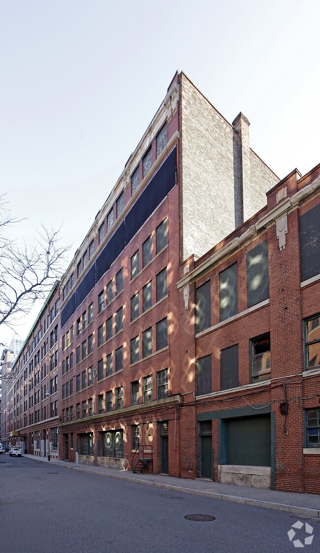
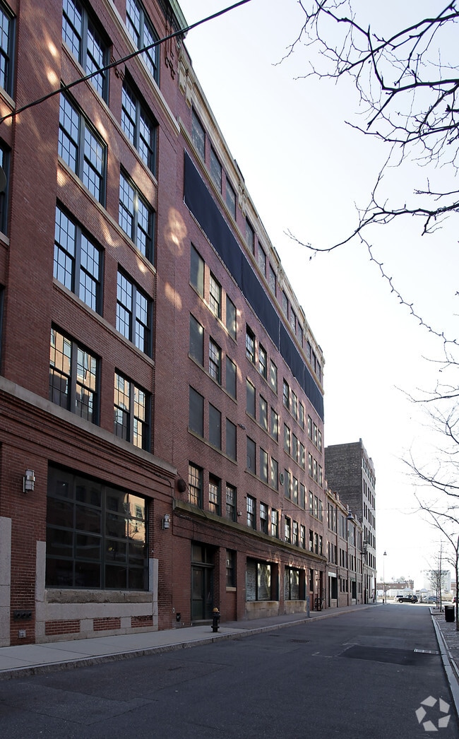
9 Channel Ctr St
Officebuilding
SUFFOLK
C
Massachusetts
AE The base floodplain where base flood elevations are provided. AE Zones are now used on new format FIRMs instead of A1-A30 Zones.
0.36 AC
2025
Ft Pt Chan/S Boston
2025
Boston
061204
Boston-Cambridge-Newton, MA-NH
73,553 SF
SBOS-000000-000006-002750-000045
NEARBY LISTINGS FOR SALE OR LEASE
DEMOGRAPHICS near 9 Channel Ctr St
1 mile
3 mile
5 mile
2025 Total Population
61,325
399,912
906,666
2030 Population
64,337
413,814
930,897
Pop Growth 2025-2030
+ 4.91%
+ 3.48%
+ 2.67%
Average Age
39
36
37
2025 Total Households
29,421
170,140
373,372
HH Growth 2025-2030
+ 5.20%
+ 3.90%
+ 3.05%
Median Household Inc
$155,845
$103,807
$102,341
Avg Household Size
1.90
2.00
2.20
2025 Avg HH Vehicles
1.00
1.00
1.00
Median Home Value
$930,648
$879,157
$831,412
Median Year Built
2000
1956
1949
Nearby Places
Map Layers
Map Styles
 Street
 Aerial
Layers
 Traffic
 Biking
Places
Listings with unknown addresses are not visible on the map
- Restaurants
- Banks
- Shops
- Fitness
- Groceries
PUBLIC TRANSPORTATION
TRANSIT/SUBWAY
Broadway Station (Red Line - Massachusetts Bay Transportation Authority Subway (The T))
Drive
Walk
Distance
Broadway Station (Red Line - Massachusetts Bay Transportation Authority Subway (The T))
2 min
9 min
0.4 mi
South Station (Fairmount Line - Massachusetts Bay Transportation Authority Commuter Rail (Purple Line), Framingham/Worcester Line - Massachusetts Bay Transportation Authority Commuter Rail (Purple Line), Franklin Line - Massachusetts Bay Transportation Authority Commuter Rail (Purple Line), Greenbush Line - Massachusetts Bay Transportation Authority Commuter Rail (Purple Line), Kingston/Plymouth Line - Massachusetts Bay Transportation Authority Commuter Rail (Purple Line), Middleborough/Lakeville Line - Massachusetts Bay Transportation Authority Commuter Rail (Purple Line), Needham Line - Massachusetts Bay Transportation Authority Commuter Rail (Purple Line), Providence/Stoughton Line - Massachusetts Bay Transportation Authority Commuter Rail (Purple Line))
Drive
Walk
Distance
South Station (Fairmount Line - Massachusetts Bay Transportation Authority Commuter Rail (Purple Line), Framingham/Worcester Line - Massachusetts Bay Transportation Authority Commuter Rail (Purple Line), Franklin Line - Massachusetts Bay Transportation Authority Commuter Rail (Purple Line), Greenbush Line - Massachusetts Bay Transportation Authority Commuter Rail (Purple Line), Kingston/Plymouth Line - Massachusetts Bay Transportation Authority Commuter Rail (Purple Line), Middleborough/Lakeville Line - Massachusetts Bay Transportation Authority Commuter Rail (Purple Line), Needham Line - Massachusetts Bay Transportation Authority Commuter Rail (Purple Line), Providence/Stoughton Line - Massachusetts Bay Transportation Authority Commuter Rail (Purple Line))
4 min
13 min
0.7 mi
South Station (Red Line - Massachusetts Bay Transportation Authority Subway (The T), Silver Line 1 - Massachusetts Bay Transportation Authority Subway (The T), Silver Line 2 - Massachusetts Bay Transportation Authority Subway (The T))
Drive
Walk
Distance
South Station (Red Line - Massachusetts Bay Transportation Authority Subway (The T), Silver Line 1 - Massachusetts Bay Transportation Authority Subway (The T), Silver Line 2 - Massachusetts Bay Transportation Authority Subway (The T))
3 min
13 min
0.7 mi
COMMUTER RAIL
South Station (Fairmount Line - Massachusetts Bay Transportation Authority Commuter Rail (Purple Line), Framingham/Worcester Line - Massachusetts Bay Transportation Authority Commuter Rail (Purple Line), Franklin Line - Massachusetts Bay Transportation Authority Commuter Rail (Purple Line), Greenbush Line - Massachusetts Bay Transportation Authority Commuter Rail (Purple Line), Kingston/Plymouth Line - Massachusetts Bay Transportation Authority Commuter Rail (Purple Line), Middleborough/Lakeville Line - Massachusetts Bay Transportation Authority Commuter Rail (Purple Line), Needham Line - Massachusetts Bay Transportation Authority Commuter Rail (Purple Line), Providence/Stoughton Line - Massachusetts Bay Transportation Authority Commuter Rail (Purple Line))
Drive
Walk
Distance
South Station (Fairmount Line - Massachusetts Bay Transportation Authority Commuter Rail (Purple Line), Framingham/Worcester Line - Massachusetts Bay Transportation Authority Commuter Rail (Purple Line), Franklin Line - Massachusetts Bay Transportation Authority Commuter Rail (Purple Line), Greenbush Line - Massachusetts Bay Transportation Authority Commuter Rail (Purple Line), Kingston/Plymouth Line - Massachusetts Bay Transportation Authority Commuter Rail (Purple Line), Middleborough/Lakeville Line - Massachusetts Bay Transportation Authority Commuter Rail (Purple Line), Needham Line - Massachusetts Bay Transportation Authority Commuter Rail (Purple Line), Providence/Stoughton Line - Massachusetts Bay Transportation Authority Commuter Rail (Purple Line))
4 min
14 min
0.7 mi
North Station (Fitchburg/South Acton Line - Massachusetts Bay Transportation Authority Commuter Rail (Purple Line), Haverhill Line - Massachusetts Bay Transportation Authority Commuter Rail (Purple Line), Lowell Line - Massachusetts Bay Transportation Authority Commuter Rail (Purple Line), Newburyport/Rockport Line - Massachusetts Bay Transportation Authority Commuter Rail (Purple Line))
Drive
Walk
Distance
North Station (Fitchburg/South Acton Line - Massachusetts Bay Transportation Authority Commuter Rail (Purple Line), Haverhill Line - Massachusetts Bay Transportation Authority Commuter Rail (Purple Line), Lowell Line - Massachusetts Bay Transportation Authority Commuter Rail (Purple Line), Newburyport/Rockport Line - Massachusetts Bay Transportation Authority Commuter Rail (Purple Line))
7 min
2.0 mi
AIRPORT
General Edward Lawrence Logan International
Drive
Walk
Distance
General Edward Lawrence Logan International
8 min
3.8 mi
Freight Ports
Port of Boston
Drive
Walk
Distance
Port of Boston
6 min
1.9 mi
Nearby Properties
Address
Land Use
TOTAL SIZE
Lot Size
Zoning
Address
Land Use
TOTAL SIZE
Lot Size
Zoning
909,764 SF
25.13 AC
E
Address
Land Use
TOTAL SIZE
Lot Size
Zoning
610,560 SF
4.01 AC
E
Address
Land Use
TOTAL SIZE
Lot Size
Zoning
408,667 SF
3.27 AC
C
Address
Land Use
TOTAL SIZE
Lot Size
Zoning
825,000 SF
5.17 AC
E
Address
Land Use
TOTAL SIZE
Lot Size
Zoning
6.39 AC
C
Address
Land Use
TOTAL SIZE
Lot Size
Zoning
596,972 SF
7.32 AC
E
Address
Land Use
TOTAL SIZE
Lot Size
Zoning
171,791 SF
166.88 AC
E
Address
Land Use
TOTAL SIZE
Lot Size
Zoning
173,400 SF
1.14 AC
MXD
Address
Land Use
TOTAL SIZE
Lot Size
Zoning
334,522 SF
1.26 AC
C
Address
Land Use
TOTAL SIZE
Lot Size
Zoning
312,269 SF
0.43 AC
C
Address
Land Use
TOTAL SIZE
Lot Size
Zoning
230,394 SF
0.60 AC
MXD
Address
Land Use
TOTAL SIZE
Lot Size
Zoning
46,259 SF
1.05 AC
E
Address
Land Use
TOTAL SIZE
Lot Size
Zoning
118,759 SF
0.92 AC
C
Address
Land Use
TOTAL SIZE
Lot Size
Zoning
3.52 AC
C-3
Address
Land Use
TOTAL SIZE
Lot Size
Zoning
377,634 SF
4.86 AC
E
Address
Land Use
TOTAL SIZE
Lot Size
Zoning
1.13 AC
C
Address
Land Use
TOTAL SIZE
Lot Size
Zoning
239,377 SF
0.71 AC
MXD
Address
Land Use
TOTAL SIZE
Lot Size
Zoning
3.75 AC
C
Address
Land Use
TOTAL SIZE
Lot Size
Zoning
227,107 SF
7.70 AC
E
Address
Land Use
TOTAL SIZE
Lot Size
Zoning
448,796 SF
1.84 AC
C
Address
Land Use
TOTAL SIZE
Lot Size
Zoning
341,500 SF
1.18 AC
RC
Address
Land Use
TOTAL SIZE
Lot Size
Zoning
252,392 SF
0.52 AC
C
Address
Land Use
TOTAL SIZE
Lot Size
Zoning
325,020 SF
0.62 AC
RC
Address
Land Use
TOTAL SIZE
Lot Size
Zoning
237,935 SF
1.27 AC
C-3
Address
Land Use
TOTAL SIZE
Lot Size
Zoning
619,050 SF
0.45 AC
C
Address
Land Use
TOTAL SIZE
Lot Size
Zoning
259,990 SF
2.84 AC
E
Address
Land Use
TOTAL SIZE
Lot Size
Zoning
6.14 AC
C
Address
Land Use
TOTAL SIZE
Lot Size
Zoning
547,851 SF
8.14 AC
E
Address
Land Use
TOTAL SIZE
Lot Size
Zoning
305,455 SF
0.54 AC
RC
Address
Land Use
TOTAL SIZE
Lot Size
Zoning
138,316 SF
0.19 AC
RC
The World's #1 Commercial Real Estate Marketplace
Connect with us
© 2026 CoStar Group
The information above has been obtained from sources believed reliable. While we do not doubt its accuracy we have not verified it and make no guarantee, warranty or representation about it. It is your responsibility to independently confirm its accuracy and completeness. Any projections, opinions, assumptions, or estimates used are for example only and do not represent the current or future performance of the property. The value of this transaction to you depends on tax and other factors which should be evaluated by your tax, financial, and legal advisors. You and your advisors should conduct a careful, independent investigation of the property to determine to your satisfaction the suitability of the property for your needs.