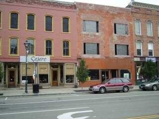
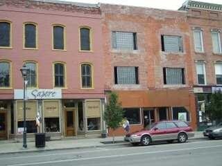
Property Record
9 E Main St, Brocton, NY 14716
Property Detail
9 E Main St
Jamestown-Dunkirk, NY
OLD APN: 064801 103-3-5.2
066001-145-017-0003-002-000
CHAUTAUQUA
Autorepair
New York
01 - NOT Z
25.000
2025
4 AC
2025
New York West Area
036802
Other Market Areas
1,248 SF
NEARBY LISTINGS FOR SALE OR LEASE
-
-
View all Brocton listings for sale on LoopNet.com
DEMOGRAPHICS near 9 E Main St
1 mile
3 mile
5 mile
2025 Total Population
2,536
4,023
5,067
2030 Population
2,486
3,963
5,008
Pop Growth 2025-2030
(1.97%)
(1.49%)
(1.16%)
Average Age
45
46
46
2025 Total Households
1,119
1,758
2,201
HH Growth 2025-2030
(2.32%)
(1.82%)
(1.50%)
Median Household Inc
$46,677
$48,410
$49,312
Avg Household Size
2.20
2.20
2.20
2025 Avg HH Vehicles
1.00
2.00
2.00
Median Home Value
$103,952
$111,317
$118,923
Median Year Built
1953
1955
1956
Nearby Places
Map Layers
Map Styles
 Street
 Aerial
Layers
 Traffic
 Biking
Places
Listings with unknown addresses are not visible on the map
- Restaurants
- Banks
- Shops
- Fitness
- Groceries
Nearby Properties
Address
Land Use
TOTAL SIZE
Lot Size
Zoning
Address
Land Use
TOTAL SIZE
Lot Size
Zoning
59.70 AC
04 - FARM
Address
Land Use
TOTAL SIZE
Lot Size
Zoning
30.20 AC
04 - FARM
Address
Land Use
TOTAL SIZE
Lot Size
Zoning
141,847 SF
34.20 AC
01 - NOT Z
Address
Land Use
TOTAL SIZE
Lot Size
Zoning
19.10 AC
04 - FARM
Address
Land Use
TOTAL SIZE
Lot Size
Zoning
4,360 SF
7.70 AC
01 - NOT Z
Address
Land Use
TOTAL SIZE
Lot Size
Zoning
12,300 SF
53.30 AC
04 - FARM
Address
Land Use
TOTAL SIZE
Lot Size
Zoning
28,072 SF
3.90 AC
01 - NOT Z
Address
Land Use
TOTAL SIZE
Lot Size
Zoning
1,152 SF
12.20 AC
02 - SINGL
Address
Land Use
TOTAL SIZE
Lot Size
Zoning
15.40 AC
04 - FARM
Address
Land Use
TOTAL SIZE
Lot Size
Zoning
12,364 SF
232.10 AC
04 - FARM
Address
Land Use
TOTAL SIZE
Lot Size
Zoning
720 SF
16.40 AC
04 - FARM
Address
Land Use
TOTAL SIZE
Lot Size
Zoning
7,200 SF
0.90 AC
01 - NOT Z
Address
Land Use
TOTAL SIZE
Lot Size
Zoning
938 SF
25.90 AC
04 - FARM
Address
Land Use
TOTAL SIZE
Lot Size
Zoning
6,200 SF
43.20 AC
04 - FARM
Address
Land Use
TOTAL SIZE
Lot Size
Zoning
5,185 SF
0.76 AC
01 - NOT Z
Address
Land Use
TOTAL SIZE
Lot Size
Zoning
728 SF
27.10 AC
01 - NOT Z
Address
Land Use
TOTAL SIZE
Lot Size
Zoning
9,100 SF
1.40 AC
01 - NOT Z
Address
Land Use
TOTAL SIZE
Lot Size
Zoning
6,750 SF
2 AC
05 - COMME
Address
Land Use
TOTAL SIZE
Lot Size
Zoning
55.20 AC
04 - FARM
Address
Land Use
TOTAL SIZE
Lot Size
Zoning
4,133 SF
1.50 AC
01 - NOT Z
Address
Land Use
TOTAL SIZE
Lot Size
Zoning
5,000 SF
0.72 AC
01 - NOT Z
Address
Land Use
TOTAL SIZE
Lot Size
Zoning
1,822 SF
1.30 AC
05 - COMME
Address
Land Use
TOTAL SIZE
Lot Size
Zoning
68,155 SF
7.40 AC
01 - NOT Z
Address
Land Use
TOTAL SIZE
Lot Size
Zoning
1,368 SF
0.10 AC
07 - MIXED
Address
Land Use
TOTAL SIZE
Lot Size
Zoning
4,065 SF
0.53 AC
01 - NOT Z
Address
Land Use
TOTAL SIZE
Lot Size
Zoning
2,030 SF
6 AC
04 - FARM
Address
Land Use
TOTAL SIZE
Lot Size
Zoning
1 AC
04 - FARM
Address
Land Use
TOTAL SIZE
Lot Size
Zoning
7,310 SF
2.60 AC
01 - NOT Z
Address
Land Use
TOTAL SIZE
Lot Size
Zoning
9,877 SF
3.10 AC
01 - NOT Z
Address
Land Use
TOTAL SIZE
Lot Size
Zoning
45,200 SF
6.40 AC
01 - NOT Z
The World's #1 Commercial Real Estate Marketplace
Connect with us
© 2026 CoStar Group
The information above has been obtained from sources believed reliable. While we do not doubt its accuracy we have not verified it and make no guarantee, warranty or representation about it. It is your responsibility to independently confirm its accuracy and completeness. Any projections, opinions, assumptions, or estimates used are for example only and do not represent the current or future performance of the property. The value of this transaction to you depends on tax and other factors which should be evaluated by your tax, financial, and legal advisors. You and your advisors should conduct a careful, independent investigation of the property to determine to your satisfaction the suitability of the property for your needs.