Property Record
9 Enterprise Way, Dayton, NV 89403

Save to a Folder
{{folder.Name}}
{{folder.ListingIds.length}} Properties
{{folder.ListingIds.length}} Property
Create a New Folder
Property Detail
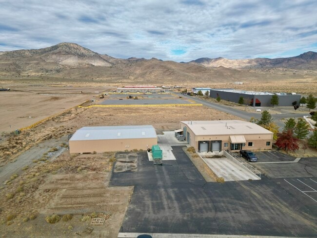
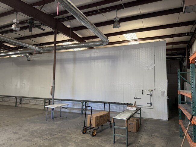
9 Enterprise Way
016-402-10
1.42 USABLE; ADJ MADE 3/99
Lightindustrial
Lyon
M1
Nevada
C and X Area of minimal flood hazard, usually depicted on FIRMs as above the 500-year flood level.
3
2026
2.15 AC
2025
S Lyon County
960305
Reno/Sparks
5,250 SF
Reno, NV
NEARBY LISTINGS FOR SALE OR LEASE
DEMOGRAPHICS near 9 Enterprise Way
1 mile
3 mile
5 mile
2025 Total Population
1,112
15,426
18,711
2030 Population
1,170
16,279
19,728
Pop Growth 2025-2030
+ 5.22%
+ 5.53%
+ 5.44%
Average Age
40
44
44
2025 Total Households
391
6,018
7,310
HH Growth 2025-2030
+ 5.12%
+ 5.48%
+ 5.36%
Median Household Inc
$108,823
$92,303
$91,822
Avg Household Size
2.70
2.50
2.50
2025 Avg HH Vehicles
3.00
2.00
2.00
Median Home Value
$347,777
$427,052
$429,567
Median Year Built
2002
2000
2001
Nearby Places
Map Layers
Map Styles
 Street
 Aerial
Layers
 Traffic
 Biking
Places
Listings with unknown addresses are not visible on the map
- Restaurants
- Banks
- Shops
- Fitness
- Groceries
PUBLIC TRANSPORTATION
AIRPORT
Reno/Tahoe International
Drive
Walk
Distance
Reno/Tahoe International
71 min
44.5 mi
Freight Ports
Port of Stockton
Drive
Walk
Distance
Port of Stockton
239 min
166.2 mi
SALE & LEASE HISTORY
LISTING DATE
SALE/LEASE

Nov 04, 2024
For Sale
Feb 26, 2025
For Lease
Nearby Properties
Address
Land Use
TOTAL SIZE
Lot Size
Zoning
Address
Land Use
TOTAL SIZE
Lot Size
Zoning
350,286 SF
14.77 AC
ME
Address
Land Use
TOTAL SIZE
Lot Size
Zoning
32,460 SF
37.48 AC
RR5
Address
Land Use
TOTAL SIZE
Lot Size
Zoning
9,804 SF
3.31 AC
MFR
Address
Land Use
TOTAL SIZE
Lot Size
Zoning
64,532 SF
7 AC
C2
Address
Land Use
TOTAL SIZE
Lot Size
Zoning
47,941 SF
10.33 AC
MULT
Address
Land Use
TOTAL SIZE
Lot Size
Zoning
38,576 SF
80.45 AC
RR5
Address
Land Use
TOTAL SIZE
Lot Size
Zoning
1,579 SF
6.73 AC
C2
Address
Land Use
TOTAL SIZE
Lot Size
Zoning
9,600 SF
4.50 AC
C2
Address
Land Use
TOTAL SIZE
Lot Size
Zoning
5,760 SF
3 AC
M1
Address
Land Use
TOTAL SIZE
Lot Size
Zoning
19,934 SF
2.18 AC
C2
Address
Land Use
TOTAL SIZE
Lot Size
Zoning
20,100 SF
6.58 AC
C1
Address
Land Use
TOTAL SIZE
Lot Size
Zoning
21,119 SF
3.10 AC
C2
Address
Land Use
TOTAL SIZE
Lot Size
Zoning
2,989 SF
3.21 AC
C2
Address
Land Use
TOTAL SIZE
Lot Size
Zoning
15,264 SF
1.60 AC
C2
Address
Land Use
TOTAL SIZE
Lot Size
Zoning
9,880 SF
2.31 AC
NR2
Address
Land Use
TOTAL SIZE
Lot Size
Zoning
35,000 SF
3 AC
M1
Address
Land Use
TOTAL SIZE
Lot Size
Zoning
3,600 SF
56.13 AC
MULT
Address
Land Use
TOTAL SIZE
Lot Size
Zoning
21,349 SF
1.82 AC
C2
Address
Land Use
TOTAL SIZE
Lot Size
Zoning
17.04 AC
C2
Address
Land Use
TOTAL SIZE
Lot Size
Zoning
672 SF
5.37 AC
C2
Address
Land Use
TOTAL SIZE
Lot Size
Zoning
42.04 AC
C2
Address
Land Use
TOTAL SIZE
Lot Size
Zoning
29,290 SF
2 AC
M1
Address
Land Use
TOTAL SIZE
Lot Size
Zoning
15,773 SF
1.80 AC
NR1
Address
Land Use
TOTAL SIZE
Lot Size
Zoning
18,456 SF
1.35 AC
C2
Address
Land Use
TOTAL SIZE
Lot Size
Zoning
37,200 SF
5.55 AC
M1
Address
Land Use
TOTAL SIZE
Lot Size
Zoning
15,543 SF
1.44 AC
C2
Address
Land Use
TOTAL SIZE
Lot Size
Zoning
4,644 SF
1.18 AC
C2
Address
Land Use
TOTAL SIZE
Lot Size
Zoning
12,644 SF
0.37 AC
C2
Address
Land Use
TOTAL SIZE
Lot Size
Zoning
4,537 SF
35.19 AC
RR2T
The World's #1 Commercial Real Estate Marketplace
Connect with us
© 2026 CoStar Group
The information above has been obtained from sources believed reliable. While we do not doubt its accuracy we have not verified it and make no guarantee, warranty or representation about it. It is your responsibility to independently confirm its accuracy and completeness. Any projections, opinions, assumptions, or estimates used are for example only and do not represent the current or future performance of the property. The value of this transaction to you depends on tax and other factors which should be evaluated by your tax, financial, and legal advisors. You and your advisors should conduct a careful, independent investigation of the property to determine to your satisfaction the suitability of the property for your needs.