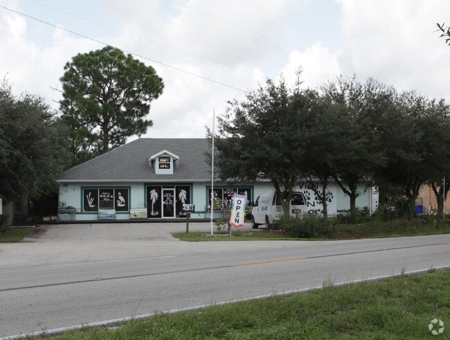
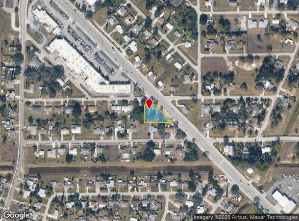
Property Record
9 Homestead Rd N, Lehigh Acres, FL 33936

NEARBY LISTINGS FOR SALE OR LEASE
Property Detail
9 Homestead Rd N
Cape Coral-Fort Myers, FL
Lee Blvd Corridor
32-44-27-01-00002.0220
LEELAND HEIGHTS UNIT NO.1 BLK.2 PB 9 PG 124 LOTS 22 + 23
Storemultistory
Lee
X
Florida
12071C0475F
22,23
2024
0.40 AC
2025
Lehigh
040311
Southwest Florida
3,000 SF
DEMOGRAPHICS near 9 Homestead Rd N
1 Mile
3 Mile
5 Mile
2024 Total Population
9,759
45,880
90,729
2029 Population
11,397
53,891
106,840
Pop Growth 2024-2029
+ 16.78%
+ 17.46%
+ 17.76%
Average Age
42
38
36
2024 Total Households
4,045
15,865
29,571
HH Growth 2024-2029
+ 16.04%
+ 16.86%
+ 17.21%
Median Household Inc
$31,449
$50,934
$54,970
Avg Household Size
2.30
2.80
2.90
2024 Avg HH Vehicles
2.00
2.00
2.00
Median Home Value
$145,654
$197,636
$208,701
Median Year Built
1975
1994
2001
Nearby Places
Map Layers
Map Styles
 Street
 Aerial
- Restaurants
- Banks
- Shops
- Fitness
- Groceries
PUBLIC TRANSPORTATION
AIRPORT
Southwest Florida International
DRIVE
WALK
Distance
Southwest Florida International
23 min
12.2 mi
Freight Ports
Port Manatee
DRIVE
WALK
Distance
Port Manatee
129 min
107.8 mi
SALE & LEASE HISTORY
LISTING DATE
SALE/LEASE

Sep 24, 2016
For Sale
Mar 23, 2018
For Sale
Mar 23, 2018
For Lease
Dec 04, 2017
For Lease
Nearby Properties
Address
Land Use
TOTAL SIZE
Lot Size
Zoning
Address
Land Use
TOTAL SIZE
Lot Size
Zoning
187,647 SF
31.50 AC
RPD
Address
Land Use
TOTAL SIZE
Lot Size
Zoning
306,514 SF
18.98 AC
CF
Address
Land Use
TOTAL SIZE
Lot Size
Zoning
101,213 SF
11.60 AC
C-2
Address
Land Use
TOTAL SIZE
Lot Size
Zoning
127,308 SF
11.13 AC
C-2
Address
Land Use
TOTAL SIZE
Lot Size
Zoning
114,134 SF
10.67 AC
C-2
Address
Land Use
TOTAL SIZE
Lot Size
Zoning
141,205 SF
33.03 AC
CF
Address
Land Use
TOTAL SIZE
Lot Size
Zoning
162,704 SF
25.47 AC
C-1A
Address
Land Use
TOTAL SIZE
Lot Size
Zoning
56,299 SF
5.57 AC
CF-2
Address
Land Use
TOTAL SIZE
Lot Size
Zoning
200,845 SF
30.04 AC
CPD
Address
Land Use
TOTAL SIZE
Lot Size
Zoning
143,777 SF
14.23 AC
RS-1
Address
Land Use
TOTAL SIZE
Lot Size
Zoning
141,740 SF
7.62 AC
CFPD
Address
Land Use
TOTAL SIZE
Lot Size
Zoning
83,611 SF
7.15 AC
C-2
Address
Land Use
TOTAL SIZE
Lot Size
Zoning
98,405 SF
15.48 AC
CS-1
Address
Land Use
TOTAL SIZE
Lot Size
Zoning
3.69 AC
RM-2
Address
Land Use
TOTAL SIZE
Lot Size
Zoning
67,323 SF
4.91 AC
CPD
Address
Land Use
TOTAL SIZE
Lot Size
Zoning
1,160 SF
106.33 AC
AG-2
Address
Land Use
TOTAL SIZE
Lot Size
Zoning
84,572 SF
4.17 AC
C-2
Address
Land Use
TOTAL SIZE
Lot Size
Zoning
46,885 SF
6.94 AC
CPD
Address
Land Use
TOTAL SIZE
Lot Size
Zoning
30,526 SF
6.52 AC
C-2
Address
Land Use
TOTAL SIZE
Lot Size
Zoning
34,650 SF
0.61 AC
C-1A
Address
Land Use
TOTAL SIZE
Lot Size
Zoning
88,075 SF
7.85 AC
CFPD
Address
Land Use
TOTAL SIZE
Lot Size
Zoning
250,479 SF
25.47 AC
RM-2
Address
Land Use
TOTAL SIZE
Lot Size
Zoning
31,770 SF
3.04 AC
C-2
Address
Land Use
TOTAL SIZE
Lot Size
Zoning
23,199 SF
2.76 AC
C-2
Address
Land Use
TOTAL SIZE
Lot Size
Zoning
161,390 SF
21.85 AC
RM-2
Address
Land Use
TOTAL SIZE
Lot Size
Zoning
21,646 SF
2.53 AC
C-2
Address
Land Use
TOTAL SIZE
Lot Size
Zoning
41,564 SF
3.91 AC
CG
Address
Land Use
TOTAL SIZE
Lot Size
Zoning
89,290 SF
9.40 AC
C-2
Address
Land Use
TOTAL SIZE
Lot Size
Zoning
0.88 AC
C-1
Address
Land Use
TOTAL SIZE
Lot Size
Zoning
16,764 SF
1.99 AC
CPD
The World's #1 Commercial Real Estate Marketplace
Connect with us
© 2025 CoStar Group
The information above has been obtained from sources believed reliable. While we do not doubt its accuracy we have not verified it and make no guarantee, warranty or representation about it. It is your responsibility to independently confirm its accuracy and completeness. Any projections, opinions, assumptions, or estimates used are for example only and do not represent the current or future performance of the property. The value of this transaction to you depends on tax and other factors which should be evaluated by your tax, financial, and legal advisors. You and your advisors should conduct a careful, independent investigation of the property to determine to your satisfaction the suitability of the property for your needs.