Property Record
9 Iron Bridge Rd, Trenton, NJ 08620
NEARBY LISTINGS FOR SALE OR LEASE
-
-
View all Trenton listings for sale on LoopNet.com
Property Detail
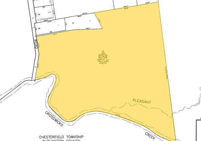
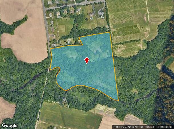
9 Iron Bridge Rd
Trenton, NJ
12850-A
03-02743-0000-00036
Mercer
Governmentalpublicusegeneral
New Jersey
AE
36
34005C0063F
36.82 AC
0
Trenton
2025
Northern New Jersey
003001
DEMOGRAPHICS near 9 Iron Bridge Rd
1 Mile
3 Mile
5 Mile
2024 Total Population
443
10,406
43,409
2029 Population
435
10,355
43,375
Pop Growth 2024-2029
(1.81%)
(0.49%)
(0.08%)
Average Age
44
40
42
2024 Total Households
149
3,474
15,098
HH Growth 2024-2029
(2.01%)
(0.78%)
(0.23%)
Median Household Inc
$169,791
$156,879
$114,011
Avg Household Size
2.90
3.00
2.70
2024 Avg HH Vehicles
3.00
2.00
2.00
Median Home Value
$466,666
$471,906
$372,597
Median Year Built
1983
1994
1979
Nearby Places
Map Layers
Map Styles
 Street
 Aerial
- Restaurants
- Banks
- Shops
- Fitness
- Groceries
PUBLIC TRANSPORTATION
AIRPORT
Trenton Mercer
DRIVE
WALK
Distance
Trenton Mercer
32 min
16.7 mi
Freight Ports
Port of Philadelphia
DRIVE
WALK
Distance
Port of Philadelphia
54 min
36.3 mi
Nearby Properties
Address
Land Use
TOTAL SIZE
Lot Size
Zoning
Address
Land Use
TOTAL SIZE
Lot Size
Zoning
134,000 SF
117.90 AC
AR
Address
Land Use
TOTAL SIZE
Lot Size
Zoning
64,184 SF
8.53 AC
R85
Address
Land Use
TOTAL SIZE
Lot Size
Zoning
2,350 SF
8.80 AC
PVD2
Address
Land Use
TOTAL SIZE
Lot Size
Zoning
15,488 SF
34.01 AC
PEC
Address
Land Use
TOTAL SIZE
Lot Size
Zoning
85,838 SF
9.74 AC
GI
Address
Land Use
TOTAL SIZE
Lot Size
Zoning
63.51 AC
RRC
Address
Land Use
TOTAL SIZE
Lot Size
Zoning
5,594 SF
20.47 AC
PEC
Address
Land Use
TOTAL SIZE
Lot Size
Zoning
459 SF
38.99 AC
R15
Address
Land Use
TOTAL SIZE
Lot Size
Zoning
12,367 SF
3 AC
AR
Address
Land Use
TOTAL SIZE
Lot Size
Zoning
10 AC
R140
Address
Land Use
TOTAL SIZE
Lot Size
Zoning
14,860 SF
19.80 AC
RRC
Address
Land Use
TOTAL SIZE
Lot Size
Zoning
38.93 AC
RRC
Address
Land Use
TOTAL SIZE
Lot Size
Zoning
13,916 SF
17.91 AC
RRC
Address
Land Use
TOTAL SIZE
Lot Size
Zoning
15,759 SF
7.54 AC
RRC
Address
Land Use
TOTAL SIZE
Lot Size
Zoning
13,610 SF
5 AC
AR
Address
Land Use
TOTAL SIZE
Lot Size
Zoning
2,904 SF
101.47 AC
AR
Address
Land Use
TOTAL SIZE
Lot Size
Zoning
2,204 SF
12.28 AC
RRC
Address
Land Use
TOTAL SIZE
Lot Size
Zoning
25,435 SF
21.35 AC
AG
Address
Land Use
TOTAL SIZE
Lot Size
Zoning
1.06 AC
PVD3
Address
Land Use
TOTAL SIZE
Lot Size
Zoning
12.12 AC
Address
Land Use
TOTAL SIZE
Lot Size
Zoning
11,400 SF
2.47 AC
CC
Address
Land Use
TOTAL SIZE
Lot Size
Zoning
Address
Land Use
TOTAL SIZE
Lot Size
Zoning
Address
Land Use
TOTAL SIZE
Lot Size
Zoning
0.13 AC
OP
Address
Land Use
TOTAL SIZE
Lot Size
Zoning
3,480 SF
5 AC
R85
Address
Land Use
TOTAL SIZE
Lot Size
Zoning
20,408 SF
0.37 AC
R85
Address
Land Use
TOTAL SIZE
Lot Size
Zoning
9,935 SF
6 AC
AG
Address
Land Use
TOTAL SIZE
Lot Size
Zoning
Address
Land Use
TOTAL SIZE
Lot Size
Zoning
6,562 SF
8.40 AC
AG
Address
Land Use
TOTAL SIZE
Lot Size
Zoning
6,720 SF
2.99 AC
R85
The World's #1 Commercial Real Estate Marketplace
Connect with us
© 2025 CoStar Group
The information above has been obtained from sources believed reliable. While we do not doubt its accuracy we have not verified it and make no guarantee, warranty or representation about it. It is your responsibility to independently confirm its accuracy and completeness. Any projections, opinions, assumptions, or estimates used are for example only and do not represent the current or future performance of the property. The value of this transaction to you depends on tax and other factors which should be evaluated by your tax, financial, and legal advisors. You and your advisors should conduct a careful, independent investigation of the property to determine to your satisfaction the suitability of the property for your needs.