Property Record
9 Mcconnell Rd, Grove City, PA 16127

NEARBY LISTINGS FOR SALE OR LEASE
-
-
View all Grove City listings for sale on LoopNet.com
Property Detail
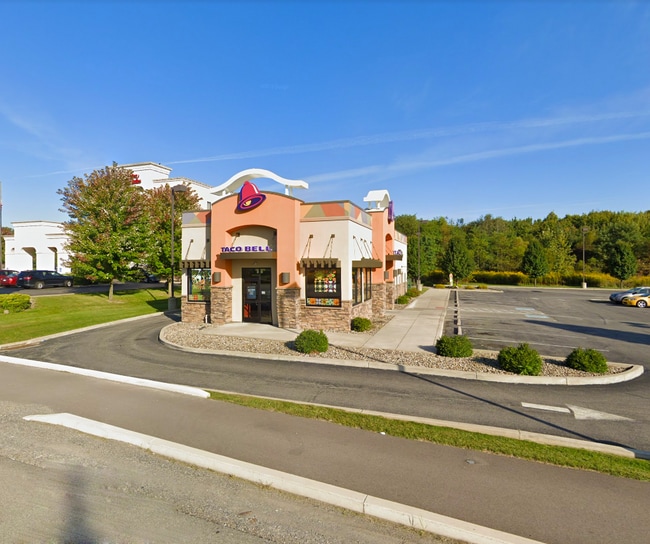
9 Mcconnell Rd
Hermitage, PA
Hosss Restaurant Operations Sub Plan No
29-217-033-006
RESTAURANT (TACO BELL) LOT 6 HOSS'S RESTAURANT OPERAT 2011PL 9435-89
Commercialnec
Mercer
X
Pennsylvania
42085C0395D
6
2025
1.01 AC
2025
Mercer County
032900
Youngstown/Warren/Boardman
DEMOGRAPHICS near 9 Mcconnell Rd
1 Mile
3 Mile
5 Mile
2024 Total Population
109
2,373
14,327
2029 Population
111
2,355
14,091
Pop Growth 2024-2029
+ 1.83%
(0.76%)
(1.65%)
Average Age
43
44
40
2024 Total Households
43
931
4,963
HH Growth 2024-2029
+ 2.33%
(0.86%)
(1.95%)
Median Household Inc
$66,000
$69,725
$67,542
Avg Household Size
2.40
2.50
2.30
2024 Avg HH Vehicles
2.00
2.00
2.00
Median Home Value
$150,000
$208,636
$180,607
Median Year Built
1973
1976
1963
Nearby Places
Map Layers
Map Styles
 Street
 Aerial
- Restaurants
- Banks
- Shops
- Fitness
- Groceries
SALE & LEASE HISTORY
LISTING DATE
SALE/LEASE

Oct 11, 2021
For Sale
Jul 01, 2019
For Sale
Nearby Properties
Address
Land Use
TOTAL SIZE
Lot Size
Zoning
Address
Land Use
TOTAL SIZE
Lot Size
Zoning
Address
Land Use
TOTAL SIZE
Lot Size
Zoning
Address
Land Use
TOTAL SIZE
Lot Size
Zoning
2.21 AC
Address
Land Use
TOTAL SIZE
Lot Size
Zoning
Address
Land Use
TOTAL SIZE
Lot Size
Zoning
2.49 AC
Address
Land Use
TOTAL SIZE
Lot Size
Zoning
25,272 SF
5 AC
Address
Land Use
TOTAL SIZE
Lot Size
Zoning
4.52 AC
Address
Land Use
TOTAL SIZE
Lot Size
Zoning
11.72 AC
Address
Land Use
TOTAL SIZE
Lot Size
Zoning
Address
Land Use
TOTAL SIZE
Lot Size
Zoning
29.13 AC
Address
Land Use
TOTAL SIZE
Lot Size
Zoning
6.97 AC
Address
Land Use
TOTAL SIZE
Lot Size
Zoning
Address
Land Use
TOTAL SIZE
Lot Size
Zoning
Address
Land Use
TOTAL SIZE
Lot Size
Zoning
1.98 AC
Address
Land Use
TOTAL SIZE
Lot Size
Zoning
Address
Land Use
TOTAL SIZE
Lot Size
Zoning
16.74 AC
Address
Land Use
TOTAL SIZE
Lot Size
Zoning
Address
Land Use
TOTAL SIZE
Lot Size
Zoning
189.79 AC
Address
Land Use
TOTAL SIZE
Lot Size
Zoning
Address
Land Use
TOTAL SIZE
Lot Size
Zoning
22.67 AC
Address
Land Use
TOTAL SIZE
Lot Size
Zoning
Address
Land Use
TOTAL SIZE
Lot Size
Zoning
Address
Land Use
TOTAL SIZE
Lot Size
Zoning
1.27 AC
Address
Land Use
TOTAL SIZE
Lot Size
Zoning
6.52 AC
Address
Land Use
TOTAL SIZE
Lot Size
Zoning
Address
Land Use
TOTAL SIZE
Lot Size
Zoning
1.48 AC
Address
Land Use
TOTAL SIZE
Lot Size
Zoning
147.13 AC
Address
Land Use
TOTAL SIZE
Lot Size
Zoning
Address
Land Use
TOTAL SIZE
Lot Size
Zoning
11.98 AC
Address
Land Use
TOTAL SIZE
Lot Size
Zoning
1.61 AC
The World's #1 Commercial Real Estate Marketplace
Connect with us
© 2026 CoStar Group
The information above has been obtained from sources believed reliable. While we do not doubt its accuracy we have not verified it and make no guarantee, warranty or representation about it. It is your responsibility to independently confirm its accuracy and completeness. Any projections, opinions, assumptions, or estimates used are for example only and do not represent the current or future performance of the property. The value of this transaction to you depends on tax and other factors which should be evaluated by your tax, financial, and legal advisors. You and your advisors should conduct a careful, independent investigation of the property to determine to your satisfaction the suitability of the property for your needs.