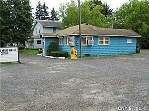
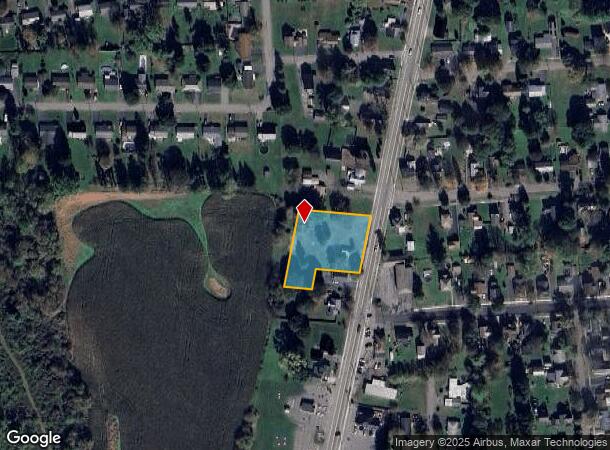
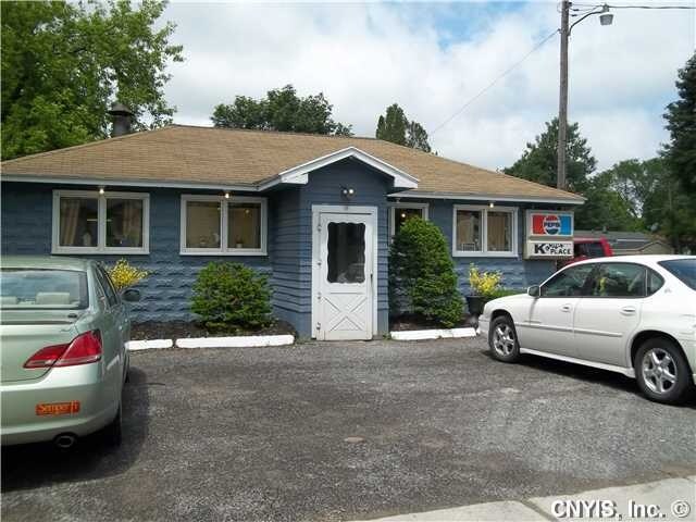
Property Record
9 N West St, Homer, NY 13077
NEARBY LISTINGS FOR SALE OR LEASE
Property Detail
9 N West St
Mobilehomepark
Cortland
X
New York
36023C0139D
21.100
2024
Cortland County
2024
Syracuse
970202
Cortland, NY
1,488 SF
113001 66.72-03-21.100
DEMOGRAPHICS near 9 N West St
1 Mile
3 Mile
5 Mile
2024 Total Population
3,040
19,409
29,605
2029 Population
2,945
19,116
29,167
Pop Growth 2024-2029
(3.13%)
(1.51%)
(1.48%)
Average Age
43
39
39
2024 Total Households
1,304
7,577
11,464
HH Growth 2024-2029
(3.30%)
(1.64%)
(1.58%)
Median Household Inc
$67,452
$58,388
$59,239
Avg Household Size
2.30
2.20
2.20
2024 Avg HH Vehicles
2.00
2.00
2.00
Median Home Value
$146,654
$148,701
$148,928
Median Year Built
1948
1948
1953
Nearby Places
- Restaurants
- Banks
- Shops
- Fitness
- Groceries
PUBLIC TRANSPORTATION
AIRPORT
Ithaca Tompkins International
DRIVE
WALK
Distance
Ithaca Tompkins International
35 min
20.8 mi
Freight Ports
Albany, NY Port
DRIVE
WALK
Distance
Albany, NY Port
202 min
158.7 mi
SALE & LEASE HISTORY
LISTING DATE
SALE/LEASE

Sep 24, 2016
For Sale
Sep 24, 2016
For Sale
Nearby Properties
Address
Land Use
TOTAL SIZE
Lot Size
Zoning
Address
Land Use
TOTAL SIZE
Lot Size
Zoning
224,991 SF
6.70 AC
05 - COMME
Address
Land Use
TOTAL SIZE
Lot Size
Zoning
138,432 SF
1.01 AC
08 - GOVER
Address
Land Use
TOTAL SIZE
Lot Size
Zoning
56,160 SF
4.60 AC
08 - GOVER
Address
Land Use
TOTAL SIZE
Lot Size
Zoning
111,968 SF
2.80 AC
08 - GOVER
Address
Land Use
TOTAL SIZE
Lot Size
Zoning
99,000 SF
7.30 AC
08 - GOVER
Address
Land Use
TOTAL SIZE
Lot Size
Zoning
107,712 SF
4.77 AC
05 - COMME
Address
Land Use
TOTAL SIZE
Lot Size
Zoning
18.30 AC
02 - SINGL
Address
Land Use
TOTAL SIZE
Lot Size
Zoning
85,324 SF
4 AC
08 - GOVER
Address
Land Use
TOTAL SIZE
Lot Size
Zoning
157,298 SF
22.09 AC
05 - COMME
Address
Land Use
TOTAL SIZE
Lot Size
Zoning
42,508 SF
3.60 AC
08 - GOVER
Address
Land Use
TOTAL SIZE
Lot Size
Zoning
107,712 SF
4.77 AC
05 - COMME
Address
Land Use
TOTAL SIZE
Lot Size
Zoning
73,182 SF
2.60 AC
08 - GOVER
Address
Land Use
TOTAL SIZE
Lot Size
Zoning
72,536 SF
2 AC
08 - GOVER
Address
Land Use
TOTAL SIZE
Lot Size
Zoning
81,680 SF
05 - COMME
Address
Land Use
TOTAL SIZE
Lot Size
Zoning
12.80 AC
03 - MULTI
Address
Land Use
TOTAL SIZE
Lot Size
Zoning
438,796 SF
15.63 AC
05 - COMME
Address
Land Use
TOTAL SIZE
Lot Size
Zoning
12,402 SF
5 AC
03 - MULTI
Address
Land Use
TOTAL SIZE
Lot Size
Zoning
74,712 SF
1.50 AC
05 - COMME
Address
Land Use
TOTAL SIZE
Lot Size
Zoning
71,348 SF
5.90 AC
08 - GOVER
Address
Land Use
TOTAL SIZE
Lot Size
Zoning
18,960 SF
0.52 AC
08 - GOVER
Address
Land Use
TOTAL SIZE
Lot Size
Zoning
86,540 SF
1.40 AC
05 - COMME
Address
Land Use
TOTAL SIZE
Lot Size
Zoning
Address
Land Use
TOTAL SIZE
Lot Size
Zoning
7.38 AC
Address
Land Use
TOTAL SIZE
Lot Size
Zoning
41,480 SF
3 AC
08 - GOVER
Address
Land Use
TOTAL SIZE
Lot Size
Zoning
60,000 SF
05 - COMME
Address
Land Use
TOTAL SIZE
Lot Size
Zoning
44,030 SF
8.60 AC
08 - GOVER
Address
Land Use
TOTAL SIZE
Lot Size
Zoning
39.20 AC
04 - FARM
Address
Land Use
TOTAL SIZE
Lot Size
Zoning
4,060 SF
53.50 AC
08 - GOVER
Address
Land Use
TOTAL SIZE
Lot Size
Zoning
45,056 SF
1.70 AC
08 - GOVER
Address
Land Use
TOTAL SIZE
Lot Size
Zoning
47,554 SF
2.30 AC
05 - COMME
The World's #1 Commercial Real Estate Marketplace
Connect with us
© 2025 CoStar Group
The information above has been obtained from sources believed reliable. While we do not doubt its accuracy we have not verified it and make no guarantee, warranty or representation about it. It is your responsibility to independently confirm its accuracy and completeness. Any projections, opinions, assumptions, or estimates used are for example only and do not represent the current or future performance of the property. The value of this transaction to you depends on tax and other factors which should be evaluated by your tax, financial, and legal advisors. You and your advisors should conduct a careful, independent investigation of the property to determine to your satisfaction the suitability of the property for your needs.