Property Record
9 Red Lion Rd, Southampton, NJ 08088


Save to a Folder
{{folder.Name}}
{{folder.ListingIds.length}} Properties
{{folder.ListingIds.length}} Property
Create a New Folder
Property Detail
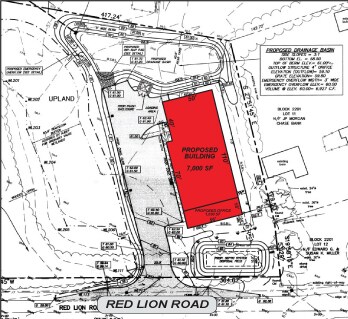
9 Red Lion Rd
33-02201-0000-00010
BURLINGTON
Governmentalpublicusegeneral
New Jersey
I
10
B and X Area of moderate flood hazard, usually the area between the limits of the 100-year and 500-year floods.
2.28 AC
2025
South Burlington County
2026
Philadelphia
703202
Philadelphia-Camden-Wilmington, PA-NJ-DE-MD
NEARBY LISTINGS FOR SALE OR LEASE
DEMOGRAPHICS near 9 Red Lion Rd
1 mile
3 mile
5 mile
2025 Total Population
268
10,895
36,499
2030 Population
272
11,193
37,506
Pop Growth 2025-2030
+ 1.49%
+ 2.74%
+ 2.76%
Average Age
42
52
45
2025 Total Households
90
4,849
14,130
HH Growth 2025-2030
+ 2.22%
+ 2.85%
+ 2.90%
Median Household Inc
$171,875
$83,302
$121,123
Avg Household Size
3.00
2.20
2.50
2025 Avg HH Vehicles
2.00
2.00
2.00
Median Home Value
$574,468
$329,024
$423,312
Median Year Built
1980
1976
1976
Nearby Places
Map Layers
Map Styles
 Street
 Aerial
Layers
 Traffic
 Biking
Places
Listings with unknown addresses are not visible on the map
- Restaurants
- Banks
- Shops
- Fitness
- Groceries
PUBLIC TRANSPORTATION
AIRPORT
Trenton Mercer
Drive
Walk
Distance
Trenton Mercer
49 min
32.3 mi
Philadelphia International
Drive
Walk
Distance
Philadelphia International
48 min
33.0 mi
Atlantic City International
Drive
Walk
Distance
Atlantic City International
72 min
39.3 mi
Freight Ports
South Jersey Port
Drive
Walk
Distance
South Jersey Port
31 min
21.7 mi
SALE & LEASE HISTORY
LISTING DATE
SALE/LEASE

Sep 24, 2016
For Sale
Nearby Properties
Address
Land Use
TOTAL SIZE
Lot Size
Zoning
Address
Land Use
TOTAL SIZE
Lot Size
Zoning
103.84 AC
PPE
Address
Land Use
TOTAL SIZE
Lot Size
Zoning
46.97 AC
Address
Land Use
TOTAL SIZE
Lot Size
Zoning
20,460 SF
23.95 AC
AR
Address
Land Use
TOTAL SIZE
Lot Size
Zoning
40.08 AC
Address
Land Use
TOTAL SIZE
Lot Size
Zoning
1,750 SF
7.91 AC
I
Address
Land Use
TOTAL SIZE
Lot Size
Zoning
5.63 AC
HC
Address
Land Use
TOTAL SIZE
Lot Size
Zoning
15.20 AC
Address
Land Use
TOTAL SIZE
Lot Size
Zoning
864 SF
4.54 AC
Address
Land Use
TOTAL SIZE
Lot Size
Zoning
8.38 AC
HC
Address
Land Use
TOTAL SIZE
Lot Size
Zoning
Address
Land Use
TOTAL SIZE
Lot Size
Zoning
4.30 AC
RGD2
Address
Land Use
TOTAL SIZE
Lot Size
Zoning
9.37 AC
I
Address
Land Use
TOTAL SIZE
Lot Size
Zoning
3.45 AC
I
Address
Land Use
TOTAL SIZE
Lot Size
Zoning
24,360 SF
15.77 AC
I
Address
Land Use
TOTAL SIZE
Lot Size
Zoning
15.65 AC
HC
Address
Land Use
TOTAL SIZE
Lot Size
Zoning
9,300 SF
26.36 AC
HC
Address
Land Use
TOTAL SIZE
Lot Size
Zoning
2.09 AC
HC
Address
Land Use
TOTAL SIZE
Lot Size
Zoning
3,366 SF
5 AC
AR
Address
Land Use
TOTAL SIZE
Lot Size
Zoning
16,000 SF
2.40 AC
I
Address
Land Use
TOTAL SIZE
Lot Size
Zoning
50.50 AC
MC
Address
Land Use
TOTAL SIZE
Lot Size
Zoning
5.30 AC
I
Address
Land Use
TOTAL SIZE
Lot Size
Zoning
3.31 AC
Address
Land Use
TOTAL SIZE
Lot Size
Zoning
5,917 SF
1 AC
AR
Address
Land Use
TOTAL SIZE
Lot Size
Zoning
13.60 AC
I
Address
Land Use
TOTAL SIZE
Lot Size
Zoning
2.86 AC
Address
Land Use
TOTAL SIZE
Lot Size
Zoning
3.28 AC
HC
Address
Land Use
TOTAL SIZE
Lot Size
Zoning
1,351 SF
1.38 AC
HC
Address
Land Use
TOTAL SIZE
Lot Size
Zoning
57.69 AC
I
Address
Land Use
TOTAL SIZE
Lot Size
Zoning
8,750 SF
3.13 AC
I
Address
Land Use
TOTAL SIZE
Lot Size
Zoning
4.62 AC
I
The World's #1 Commercial Real Estate Marketplace
Connect with us
© 2026 CoStar Group
The information above has been obtained from sources believed reliable. While we do not doubt its accuracy we have not verified it and make no guarantee, warranty or representation about it. It is your responsibility to independently confirm its accuracy and completeness. Any projections, opinions, assumptions, or estimates used are for example only and do not represent the current or future performance of the property. The value of this transaction to you depends on tax and other factors which should be evaluated by your tax, financial, and legal advisors. You and your advisors should conduct a careful, independent investigation of the property to determine to your satisfaction the suitability of the property for your needs.