Property Record
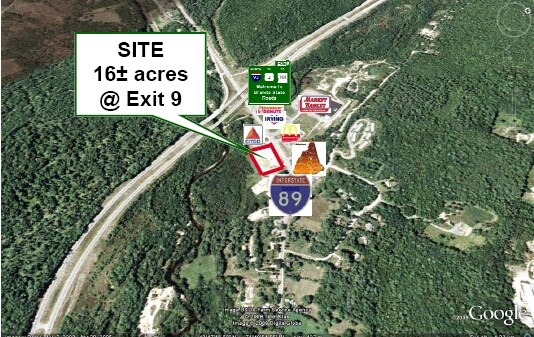
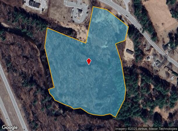
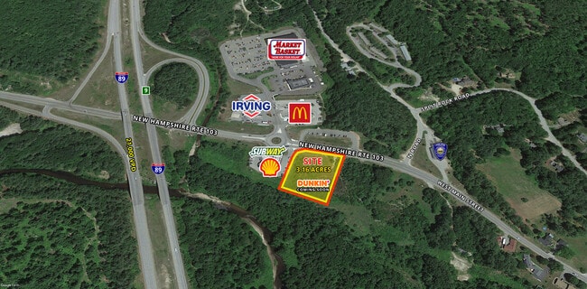
9 Route 103 W, Warner, NH 03278
Current Lease Availabilities
NEARBY LISTINGS FOR SALE OR LEASE
-
-
View all Warner listings for lease on LoopNet.com
Property Detail
9 Route 103 W
WRNR-000035-000000-000004-000001
Merrimack
Multipleuses
New Hampshire
X
4-3
33013C0287E
13.80 AC
2024
Concord/New Hampshire North Area
2024
Other Market Areas
038500
Concord, NH
DEMOGRAPHICS near 9 Route 103 W
1 Mile
3 Mile
5 Mile
2024 Total Population
626
1,869
3,348
2029 Population
656
1,953
3,514
Pop Growth 2024-2029
+ 4.79%
+ 4.49%
+ 4.96%
Average Age
45
45
45
2024 Total Households
247
741
1,333
HH Growth 2024-2029
+ 4.86%
+ 4.45%
+ 4.88%
Median Household Inc
$69,687
$77,404
$83,017
Avg Household Size
2.30
2.40
2.40
2024 Avg HH Vehicles
2.00
2.00
2.00
Median Home Value
$308,333
$320,079
$327,869
Median Year Built
1974
1975
1974
Nearby Places
- Restaurants
- Banks
- Shops
- Fitness
- Groceries
Nearby Properties
Address
Land Use
TOTAL SIZE
Lot Size
Zoning
Address
Land Use
TOTAL SIZE
Lot Size
Zoning
5,890 SF
128.68 AC
R3 - L
Address
Land Use
TOTAL SIZE
Lot Size
Zoning
63,121 SF
24.79 AC
C1 - C
Address
Land Use
TOTAL SIZE
Lot Size
Zoning
53,148 SF
2.44 AC
C1 - C
Address
Land Use
TOTAL SIZE
Lot Size
Zoning
16.50 AC
R3 - L
Address
Land Use
TOTAL SIZE
Lot Size
Zoning
31,766 SF
8.33 AC
R1 - V
Address
Land Use
TOTAL SIZE
Lot Size
Zoning
29,692 SF
4.72 AC
B1 - B
Address
Land Use
TOTAL SIZE
Lot Size
Zoning
3,912 SF
1.90 AC
C1 - C
Address
Land Use
TOTAL SIZE
Lot Size
Zoning
4,608 SF
6.32 AC
C1 - C
Address
Land Use
TOTAL SIZE
Lot Size
Zoning
7,245 SF
35.50 AC
C1 - C
Address
Land Use
TOTAL SIZE
Lot Size
Zoning
2,690 SF
10.10 AC
R2 - M
Address
Land Use
TOTAL SIZE
Lot Size
Zoning
23,175 SF
1.63 AC
C1 - C
Address
Land Use
TOTAL SIZE
Lot Size
Zoning
4,221 SF
3.60 AC
C1 - C
Address
Land Use
TOTAL SIZE
Lot Size
Zoning
1,344 AC
OR - O
Address
Land Use
TOTAL SIZE
Lot Size
Zoning
14,464 SF
4.60 AC
C1 - C
Address
Land Use
TOTAL SIZE
Lot Size
Zoning
10,668 SF
0.55 AC
B1 - B
Address
Land Use
TOTAL SIZE
Lot Size
Zoning
1,696 SF
1.48 AC
C1 - C
Address
Land Use
TOTAL SIZE
Lot Size
Zoning
6,523 SF
0.30 AC
B1 - B
Address
Land Use
TOTAL SIZE
Lot Size
Zoning
3,104 SF
3.40 AC
R3 - L
Address
Land Use
TOTAL SIZE
Lot Size
Zoning
Address
Land Use
TOTAL SIZE
Lot Size
Zoning
4,483 SF
43.09 AC
R3 - L
Address
Land Use
TOTAL SIZE
Lot Size
Zoning
10.50 AC
R1 - V
Address
Land Use
TOTAL SIZE
Lot Size
Zoning
11,160 SF
39.49 AC
R2 - M
Address
Land Use
TOTAL SIZE
Lot Size
Zoning
8,346 SF
3.90 AC
R3 - L
Address
Land Use
TOTAL SIZE
Lot Size
Zoning
11,051 SF
2.77 AC
R1 - V
Address
Land Use
TOTAL SIZE
Lot Size
Zoning
6,351 SF
0.50 AC
B1 - B
Address
Land Use
TOTAL SIZE
Lot Size
Zoning
4,935 SF
1.72 AC
C1 - C
Address
Land Use
TOTAL SIZE
Lot Size
Zoning
0.05 AC
DEFAUL
Address
Land Use
TOTAL SIZE
Lot Size
Zoning
3,540 SF
4 AC
R1 - V
Address
Land Use
TOTAL SIZE
Lot Size
Zoning
7,060 SF
6.54 AC
C1 - C
Address
Land Use
TOTAL SIZE
Lot Size
Zoning
7,101 SF
0.44 AC
B1 - B
The World's #1 Commercial Real Estate Marketplace
Connect with us
© 2025 CoStar Group
The information above has been obtained from sources believed reliable. While we do not doubt its accuracy we have not verified it and make no guarantee, warranty or representation about it. It is your responsibility to independently confirm its accuracy and completeness. Any projections, opinions, assumptions, or estimates used are for example only and do not represent the current or future performance of the property. The value of this transaction to you depends on tax and other factors which should be evaluated by your tax, financial, and legal advisors. You and your advisors should conduct a careful, independent investigation of the property to determine to your satisfaction the suitability of the property for your needs.