Property Record
9 Sand Park Rd, Cedar Grove, NJ 07009


Save to a Folder
{{folder.Name}}
{{folder.ListingIds.length}} Properties
{{folder.ListingIds.length}} Property
Create a New Folder
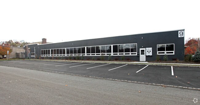
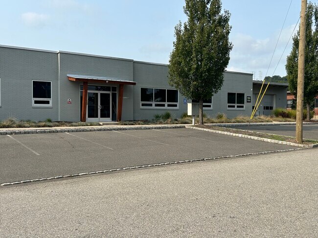
Property Detail
9 Sand Park Rd
Newark, NJ
40000 SQ FT
04-00294-0000-00021
Essex
Industrialgeneral
New Jersey
M-1
21
B and X Area of moderate flood hazard, usually the area between the limits of the 100-year and 500-year floods.
0.92 AC
2025
Suburban Essex
2026
Northern New Jersey
021300
NEARBY LISTINGS FOR SALE OR LEASE
DEMOGRAPHICS near 9 Sand Park Rd
1 mile
3 mile
5 mile
2025 Total Population
10,766
114,534
433,692
2030 Population
11,416
119,916
447,071
Pop Growth 2025-2030
+ 6.04%
+ 4.70%
+ 3.08%
Average Age
45
43
40
2025 Total Households
3,913
41,936
153,278
HH Growth 2025-2030
+ 6.18%
+ 4.89%
+ 3.32%
Median Household Inc
$143,850
$140,465
$105,749
Avg Household Size
2.60
2.60
2.70
2025 Avg HH Vehicles
2.00
2.00
2.00
Median Home Value
$675,255
$648,029
$564,944
Median Year Built
1957
1957
1955
Nearby Places
Map Layers
Map Styles
 Street
 Aerial
Layers
 Traffic
 Biking
Places
Listings with unknown addresses are not visible on the map
- Restaurants
- Banks
- Shops
- Fitness
- Groceries
PUBLIC TRANSPORTATION
COMMUTER RAIL
Little Falls (Montclair-Boonton Line - NJ Transit Commuter Rail (NJ Transit))
Drive
Walk
Distance
Little Falls (Montclair-Boonton Line - NJ Transit Commuter Rail (NJ Transit))
5 min
1.8 mi
Montclair Heights (Montclair-Boonton Line - NJ Transit Commuter Rail (NJ Transit))
Drive
Walk
Distance
Montclair Heights (Montclair-Boonton Line - NJ Transit Commuter Rail (NJ Transit))
7 min
2.7 mi
AIRPORT
Newark Liberty International
Drive
Walk
Distance
Newark Liberty International
28 min
20.5 mi
LaGuardia
Drive
Walk
Distance
LaGuardia
46 min
30.0 mi
John F Kennedy International
Drive
Walk
Distance
John F Kennedy International
58 min
35.0 mi
Freight Ports
Maher Terminal
Drive
Walk
Distance
Maher Terminal
32 min
16.3 mi
SALE & LEASE HISTORY
LISTING DATE
SALE/LEASE

Sep 25, 2025
For Lease
Mar 29, 2020
For Lease
Nearby Properties
Address
Land Use
TOTAL SIZE
Lot Size
Zoning
Address
Land Use
TOTAL SIZE
Lot Size
Zoning
667,698 SF
38.15 AC
Address
Land Use
TOTAL SIZE
Lot Size
Zoning
74.58 AC
S
Address
Land Use
TOTAL SIZE
Lot Size
Zoning
56.67 AC
Address
Land Use
TOTAL SIZE
Lot Size
Zoning
28.33 AC
Address
Land Use
TOTAL SIZE
Lot Size
Zoning
260,609 SF
35.39 AC
Address
Land Use
TOTAL SIZE
Lot Size
Zoning
49.48 AC
Address
Land Use
TOTAL SIZE
Lot Size
Zoning
20.43 AC
Address
Land Use
TOTAL SIZE
Lot Size
Zoning
2.87 AC
Address
Land Use
TOTAL SIZE
Lot Size
Zoning
Address
Land Use
TOTAL SIZE
Lot Size
Zoning
25.88 AC
Address
Land Use
TOTAL SIZE
Lot Size
Zoning
14.54 AC
R-MF
Address
Land Use
TOTAL SIZE
Lot Size
Zoning
4.60 AC
Address
Land Use
TOTAL SIZE
Lot Size
Zoning
137,286 SF
11.36 AC
M-2
Address
Land Use
TOTAL SIZE
Lot Size
Zoning
315,332 SF
19.60 AC
Address
Land Use
TOTAL SIZE
Lot Size
Zoning
24,200 SF
19.33 AC
Address
Land Use
TOTAL SIZE
Lot Size
Zoning
3.55 AC
Address
Land Use
TOTAL SIZE
Lot Size
Zoning
13.82 AC
O
Address
Land Use
TOTAL SIZE
Lot Size
Zoning
19.46 AC
Address
Land Use
TOTAL SIZE
Lot Size
Zoning
12.86 AC
Address
Land Use
TOTAL SIZE
Lot Size
Zoning
4.08 AC
Address
Land Use
TOTAL SIZE
Lot Size
Zoning
25.80 AC
P
Address
Land Use
TOTAL SIZE
Lot Size
Zoning
116,505 SF
10.77 AC
Address
Land Use
TOTAL SIZE
Lot Size
Zoning
271,679 SF
20.79 AC
Address
Land Use
TOTAL SIZE
Lot Size
Zoning
67.49 AC
Address
Land Use
TOTAL SIZE
Lot Size
Zoning
103.46 AC
R-40
Address
Land Use
TOTAL SIZE
Lot Size
Zoning
93,207 SF
23.44 AC
Address
Land Use
TOTAL SIZE
Lot Size
Zoning
1,063 SF
14.08 AC
C-1
Address
Land Use
TOTAL SIZE
Lot Size
Zoning
Address
Land Use
TOTAL SIZE
Lot Size
Zoning
49.03 AC
Address
Land Use
TOTAL SIZE
Lot Size
Zoning
5.06 AC
The World's #1 Commercial Real Estate Marketplace
Connect with us
© 2026 CoStar Group
The information above has been obtained from sources believed reliable. While we do not doubt its accuracy we have not verified it and make no guarantee, warranty or representation about it. It is your responsibility to independently confirm its accuracy and completeness. Any projections, opinions, assumptions, or estimates used are for example only and do not represent the current or future performance of the property. The value of this transaction to you depends on tax and other factors which should be evaluated by your tax, financial, and legal advisors. You and your advisors should conduct a careful, independent investigation of the property to determine to your satisfaction the suitability of the property for your needs.