Property Record
9 Spencer Dr, Bellows Falls, VT 05101
NEARBY LISTINGS FOR SALE OR LEASE
-
-
View all Bellows Falls listings for lease on LoopNet.com
Property Detail
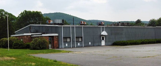
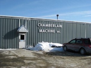
9 Spencer Dr
Industrialgeneral
BUILDING AND LAND
X
Windham
50025C0112E
Vermont
2022
2.59 AC
2024
Vermont South Area
967000
Other Market Areas
31,505 SF
528-166-10402
DEMOGRAPHICS near 9 Spencer Dr
1 Mile
3 Mile
5 Mile
2024 Total Population
207
4,838
8,829
2029 Population
206
4,900
8,944
Pop Growth 2024-2029
(0.48%)
+ 1.28%
+ 1.30%
Average Age
46
43
44
2024 Total Households
93
2,170
3,909
HH Growth 2024-2029
0.00%
+ 1.11%
+ 1.05%
Median Household Inc
$65,000
$60,525
$64,800
Avg Household Size
2.10
2.10
2.20
2024 Avg HH Vehicles
2.00
2.00
2.00
Median Home Value
$197,499
$172,750
$191,310
Median Year Built
1949
1949
1959
Nearby Places
Map Layers
Map Styles
 Street
 Aerial
- Restaurants
- Banks
- Shops
- Fitness
- Groceries
PUBLIC TRANSPORTATION
COMMUTER RAIL
Bellows Falls Amtrak Station (Vermonter - Amtrak)
DRIVE
WALK
Distance
Bellows Falls Amtrak Station (Vermonter - Amtrak)
5 min
2.8 mi
Freight Ports
Albany, NY Port
DRIVE
WALK
Distance
Albany, NY Port
152 min
99.8 mi
SALE & LEASE HISTORY
LISTING DATE
SALE/LEASE

Sep 24, 2016
For Sale
Mar 23, 2017
For Lease
Dec 31, 2019
For Lease
Dec 31, 2019
For Sale
Nearby Properties
Address
Land Use
TOTAL SIZE
Lot Size
Zoning
Address
Land Use
TOTAL SIZE
Lot Size
Zoning
13.51 AC
Address
Land Use
TOTAL SIZE
Lot Size
Zoning
Address
Land Use
TOTAL SIZE
Lot Size
Zoning
Address
Land Use
TOTAL SIZE
Lot Size
Zoning
8.30 AC
Address
Land Use
TOTAL SIZE
Lot Size
Zoning
Address
Land Use
TOTAL SIZE
Lot Size
Zoning
137,353 SF
78.12 AC
Address
Land Use
TOTAL SIZE
Lot Size
Zoning
29,488 SF
11.59 AC
Address
Land Use
TOTAL SIZE
Lot Size
Zoning
141.30 AC
Address
Land Use
TOTAL SIZE
Lot Size
Zoning
28,905 SF
5.85 AC
Address
Land Use
TOTAL SIZE
Lot Size
Zoning
60,615 SF
0.91 AC
Address
Land Use
TOTAL SIZE
Lot Size
Zoning
31,161 SF
2.36 AC
NRB11N
Address
Land Use
TOTAL SIZE
Lot Size
Zoning
13.28 AC
Address
Land Use
TOTAL SIZE
Lot Size
Zoning
62,674 SF
5.65 AC
NRB11N
Address
Land Use
TOTAL SIZE
Lot Size
Zoning
Address
Land Use
TOTAL SIZE
Lot Size
Zoning
15,187 SF
10 AC
NRB11N
Address
Land Use
TOTAL SIZE
Lot Size
Zoning
13.20 AC
Address
Land Use
TOTAL SIZE
Lot Size
Zoning
13.20 AC
Address
Land Use
TOTAL SIZE
Lot Size
Zoning
12.70 AC
Address
Land Use
TOTAL SIZE
Lot Size
Zoning
3.38 AC
Address
Land Use
TOTAL SIZE
Lot Size
Zoning
45,009 SF
2.45 AC
NRB11N
Address
Land Use
TOTAL SIZE
Lot Size
Zoning
Address
Land Use
TOTAL SIZE
Lot Size
Zoning
Address
Land Use
TOTAL SIZE
Lot Size
Zoning
0.82 AC
NRB11N
Address
Land Use
TOTAL SIZE
Lot Size
Zoning
61,104 SF
10.95 AC
Address
Land Use
TOTAL SIZE
Lot Size
Zoning
Address
Land Use
TOTAL SIZE
Lot Size
Zoning
31,998 SF
2.78 AC
Address
Land Use
TOTAL SIZE
Lot Size
Zoning
13,919 SF
0.31 AC
NCOM N
Address
Land Use
TOTAL SIZE
Lot Size
Zoning
59,040 SF
3.70 AC
NIND N
Address
Land Use
TOTAL SIZE
Lot Size
Zoning
0.33 AC
NRB11N
Address
Land Use
TOTAL SIZE
Lot Size
Zoning
4.17 AC
The World's #1 Commercial Real Estate Marketplace
Connect with us
© 2025 CoStar Group
The information above has been obtained from sources believed reliable. While we do not doubt its accuracy we have not verified it and make no guarantee, warranty or representation about it. It is your responsibility to independently confirm its accuracy and completeness. Any projections, opinions, assumptions, or estimates used are for example only and do not represent the current or future performance of the property. The value of this transaction to you depends on tax and other factors which should be evaluated by your tax, financial, and legal advisors. You and your advisors should conduct a careful, independent investigation of the property to determine to your satisfaction the suitability of the property for your needs.