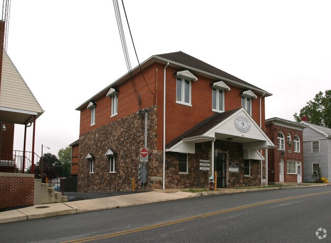
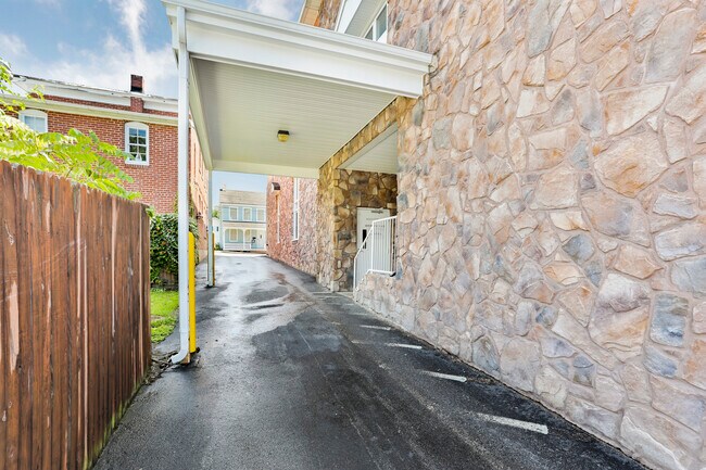
Property Record
9 Saint Paul St, Boonsboro, MD 21713

NEARBY LISTINGS FOR SALE OR LEASE
-
-
View all Boonsboro listings for lease on LoopNet.com
Property Detail
9 Saint Paul St
06-024890
LOT .25 ACRES 9 ST PAUL ST
Medicalbuilding
Washington
X
Maryland
24043C0319D
0.25 AC
2024
Washington County
2025
Washington, DC
011400
Hagerstown-Martinsburg, MD-WV
10,034 SF
DEMOGRAPHICS near 9 Saint Paul St
1 Mile
3 Mile
5 Mile
2024 Total Population
3,042
6,950
15,468
2029 Population
3,055
6,990
15,943
Pop Growth 2024-2029
+ 0.43%
+ 0.58%
+ 3.07%
Average Age
43
43
43
2024 Total Households
1,210
2,613
5,713
HH Growth 2024-2029
+ 0.50%
+ 0.61%
+ 3.12%
Median Household Inc
$106,218
$105,831
$110,835
Avg Household Size
2.50
2.60
2.70
2024 Avg HH Vehicles
2.00
2.00
3.00
Median Home Value
$304,885
$320,507
$344,827
Median Year Built
1980
1980
1981
Nearby Places
Map Layers
Map Styles
 Street
 Aerial
- Restaurants
- Banks
- Shops
- Fitness
- Groceries
PUBLIC TRANSPORTATION
AIRPORT
Hagerstown Regional/Richard A Henson Field
DRIVE
WALK
Distance
Hagerstown Regional/Richard A Henson Field
27 min
15.4 mi
SALE & LEASE HISTORY
LISTING DATE
SALE/LEASE

May 08, 2023
For Lease
Jul 03, 2023
For Lease
Nearby Properties
Address
Land Use
TOTAL SIZE
Lot Size
Zoning
Address
Land Use
TOTAL SIZE
Lot Size
Zoning
37,491 SF
92.02 AC
A
Address
Land Use
TOTAL SIZE
Lot Size
Zoning
13,600 SF
95.96 AC
U
Address
Land Use
TOTAL SIZE
Lot Size
Zoning
78,051 SF
10.05 AC
CG
Address
Land Use
TOTAL SIZE
Lot Size
Zoning
676 SF
50.65 AC
P
Address
Land Use
TOTAL SIZE
Lot Size
Zoning
44,425 SF
12.09 AC
GC
Address
Land Use
TOTAL SIZE
Lot Size
Zoning
416 SF
152.23 AC
PI
Address
Land Use
TOTAL SIZE
Lot Size
Zoning
11,913 SF
5.19 AC
TC
Address
Land Use
TOTAL SIZE
Lot Size
Zoning
2,600 SF
1.60 AC
TR
Address
Land Use
TOTAL SIZE
Lot Size
Zoning
12,604 SF
36.17 AC
RB-E
Address
Land Use
TOTAL SIZE
Lot Size
Zoning
60,721 SF
187 AC
RC
Address
Land Use
TOTAL SIZE
Lot Size
Zoning
8,948 SF
10.40 AC
GC
Address
Land Use
TOTAL SIZE
Lot Size
Zoning
7,930 SF
1.72 AC
GC
Address
Land Use
TOTAL SIZE
Lot Size
Zoning
1,760 SF
50.76 AC
U
Address
Land Use
TOTAL SIZE
Lot Size
Zoning
10,200 SF
10 AC
U
Address
Land Use
TOTAL SIZE
Lot Size
Zoning
10,032 SF
1.38 AC
SR
Address
Land Use
TOTAL SIZE
Lot Size
Zoning
3,900 SF
4.72 AC
U
Address
Land Use
TOTAL SIZE
Lot Size
Zoning
6,185 SF
7.31 AC
U
Address
Land Use
TOTAL SIZE
Lot Size
Zoning
1,344 SF
122.93 AC
P
Address
Land Use
TOTAL SIZE
Lot Size
Zoning
11,708 SF
1.85 AC
CG
Address
Land Use
TOTAL SIZE
Lot Size
Zoning
9,100 SF
1.68 AC
GC
Address
Land Use
TOTAL SIZE
Lot Size
Zoning
1,800 SF
5.06 AC
A
Address
Land Use
TOTAL SIZE
Lot Size
Zoning
1,650 SF
121.36 AC
A(R)
Address
Land Use
TOTAL SIZE
Lot Size
Zoning
4,874 SF
1.63 AC
A(R)
Address
Land Use
TOTAL SIZE
Lot Size
Zoning
1,122 SF
0.11 AC
TC
Address
Land Use
TOTAL SIZE
Lot Size
Zoning
12,704 SF
3.25 AC
U
Address
Land Use
TOTAL SIZE
Lot Size
Zoning
4,800 SF
86.25 AC
P
Address
Land Use
TOTAL SIZE
Lot Size
Zoning
1,462 SF
3.45 AC
GC
Address
Land Use
TOTAL SIZE
Lot Size
Zoning
5,220 SF
0.62 AC
GC
Address
Land Use
TOTAL SIZE
Lot Size
Zoning
59,604 SF
4.40 AC
GC
Address
Land Use
TOTAL SIZE
Lot Size
Zoning
2,880 SF
35.42 AC
A
The World's #1 Commercial Real Estate Marketplace
Connect with us
© 2026 CoStar Group
The information above has been obtained from sources believed reliable. While we do not doubt its accuracy we have not verified it and make no guarantee, warranty or representation about it. It is your responsibility to independently confirm its accuracy and completeness. Any projections, opinions, assumptions, or estimates used are for example only and do not represent the current or future performance of the property. The value of this transaction to you depends on tax and other factors which should be evaluated by your tax, financial, and legal advisors. You and your advisors should conduct a careful, independent investigation of the property to determine to your satisfaction the suitability of the property for your needs.