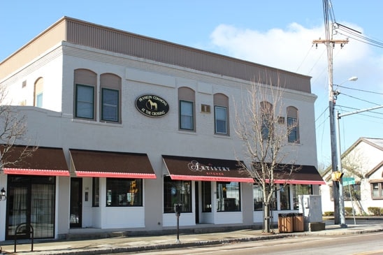
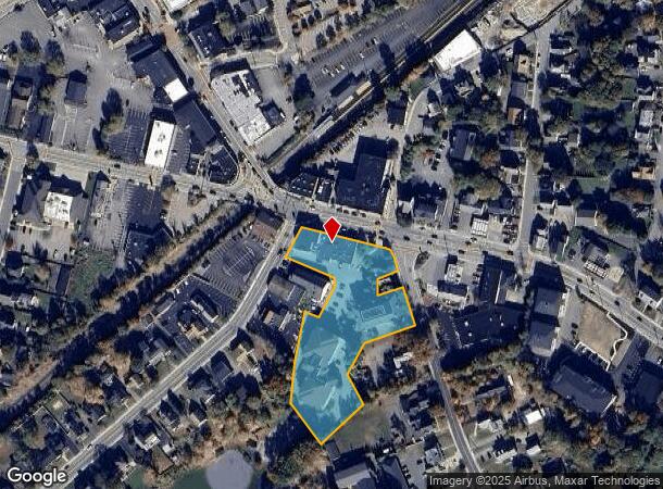
Property Record
14 E Central St, Franklin, MA 02038
NEARBY LISTINGS FOR SALE OR LEASE
Property Detail
14 E Central St
FRAN-000286-000000-000089
Norfolk
Taxexempt
Massachusetts
X
89
25021C0309F
2.36 AC
0
I-95 Corridor South
2025
Boston
442204
Boston-Cambridge-Newton, MA-NH
16,495 SF
DEMOGRAPHICS near 14 E Central St
1 Mile
3 Mile
5 Mile
2024 Total Population
9,473
32,122
71,912
2029 Population
9,424
31,965
71,655
Pop Growth 2024-2029
(0.52%)
(0.49%)
(0.36%)
Average Age
40
41
41
2024 Total Households
3,511
11,622
26,179
HH Growth 2024-2029
(0.54%)
(0.57%)
(0.40%)
Median Household Inc
$105,357
$133,358
$136,305
Avg Household Size
2.40
2.60
2.70
2024 Avg HH Vehicles
2.00
2.00
2.00
Median Home Value
$484,691
$522,008
$514,359
Median Year Built
1967
1982
1981
Nearby Places
Map Layers
Map Styles
 Street
 Aerial
- Restaurants
- Banks
- Shops
- Fitness
- Groceries
PUBLIC TRANSPORTATION
TRANSIT/SUBWAY
Franklin (Franklin Line - Massachusetts Bay Transportation Authority Commuter Rail (Purple Line))
DRIVE
WALK
Distance
Franklin (Franklin Line - Massachusetts Bay Transportation Authority Commuter Rail (Purple Line))
1 min
2 min
0.1 mi
COMMUTER RAIL
Franklin (Franklin Line - Massachusetts Bay Transportation Authority Commuter Rail (Purple Line))
DRIVE
WALK
Distance
Franklin (Franklin Line - Massachusetts Bay Transportation Authority Commuter Rail (Purple Line))
1 min
2 min
0.1 mi
Forge Park/Route 495 (Franklin Line - Massachusetts Bay Transportation Authority Commuter Rail (Purple Line))
DRIVE
WALK
Distance
Forge Park/Route 495 (Franklin Line - Massachusetts Bay Transportation Authority Commuter Rail (Purple Line))
6 min
2.5 mi
AIRPORT
Rhode Island Tf Green International
DRIVE
WALK
Distance
Rhode Island Tf Green International
50 min
28.8 mi
General Edward Lawrence Logan International
DRIVE
WALK
Distance
General Edward Lawrence Logan International
58 min
34.7 mi
Worcester Regional
DRIVE
WALK
Distance
Worcester Regional
54 min
35.7 mi
Freight Ports
Port of Boston
DRIVE
WALK
Distance
Port of Boston
56 min
32.6 mi
SALE & LEASE HISTORY
LISTING DATE
SALE/LEASE

Sep 24, 2016
For Lease
Sep 24, 2016
For Sale
Nov 04, 2016
For Lease
Mar 22, 2018
For Sale
Jul 23, 2018
For Sale
Nearby Properties
Address
Land Use
TOTAL SIZE
Lot Size
Zoning
Address
Land Use
TOTAL SIZE
Lot Size
Zoning
85.04 AC
Address
Land Use
TOTAL SIZE
Lot Size
Zoning
20.97 AC
CRPC
Address
Land Use
TOTAL SIZE
Lot Size
Zoning
23.38 AC
Address
Land Use
TOTAL SIZE
Lot Size
Zoning
Address
Land Use
TOTAL SIZE
Lot Size
Zoning
39.30 AC
Address
Land Use
TOTAL SIZE
Lot Size
Zoning
31.57 AC
Address
Land Use
TOTAL SIZE
Lot Size
Zoning
279,174 SF
59.96 AC
Address
Land Use
TOTAL SIZE
Lot Size
Zoning
0.58 AC
Address
Land Use
TOTAL SIZE
Lot Size
Zoning
148,387 SF
47.03 AC
Address
Land Use
TOTAL SIZE
Lot Size
Zoning
4.14 AC
Address
Land Use
TOTAL SIZE
Lot Size
Zoning
151,021 SF
14.56 AC
Address
Land Use
TOTAL SIZE
Lot Size
Zoning
300,000 SF
37.97 AC
Address
Land Use
TOTAL SIZE
Lot Size
Zoning
16.99 AC
Address
Land Use
TOTAL SIZE
Lot Size
Zoning
232,152 SF
17.07 AC
Address
Land Use
TOTAL SIZE
Lot Size
Zoning
39.40 AC
Address
Land Use
TOTAL SIZE
Lot Size
Zoning
152,752 SF
10.21 AC
Address
Land Use
TOTAL SIZE
Lot Size
Zoning
209,282 SF
15.61 AC
Address
Land Use
TOTAL SIZE
Lot Size
Zoning
241,740 SF
14.60 AC
Address
Land Use
TOTAL SIZE
Lot Size
Zoning
204,365 SF
16.23 AC
Address
Land Use
TOTAL SIZE
Lot Size
Zoning
269,098 SF
24.96 AC
Address
Land Use
TOTAL SIZE
Lot Size
Zoning
51.71 AC
CRPC
Address
Land Use
TOTAL SIZE
Lot Size
Zoning
130,500 SF
9.52 AC
Address
Land Use
TOTAL SIZE
Lot Size
Zoning
226,472 SF
12.07 AC
Address
Land Use
TOTAL SIZE
Lot Size
Zoning
108,202 SF
17.07 AC
CRPC
Address
Land Use
TOTAL SIZE
Lot Size
Zoning
3,024 SF
12.47 AC
C-1 80
Address
Land Use
TOTAL SIZE
Lot Size
Zoning
8.93 AC
Address
Land Use
TOTAL SIZE
Lot Size
Zoning
259,280 SF
20 AC
Address
Land Use
TOTAL SIZE
Lot Size
Zoning
50,610 SF
20.50 AC
Address
Land Use
TOTAL SIZE
Lot Size
Zoning
12.32 AC
Address
Land Use
TOTAL SIZE
Lot Size
Zoning
43.12 AC
The World's #1 Commercial Real Estate Marketplace
Connect with us
© 2025 CoStar Group
The information above has been obtained from sources believed reliable. While we do not doubt its accuracy we have not verified it and make no guarantee, warranty or representation about it. It is your responsibility to independently confirm its accuracy and completeness. Any projections, opinions, assumptions, or estimates used are for example only and do not represent the current or future performance of the property. The value of this transaction to you depends on tax and other factors which should be evaluated by your tax, financial, and legal advisors. You and your advisors should conduct a careful, independent investigation of the property to determine to your satisfaction the suitability of the property for your needs.