Property Record
9 The Pines Ct, Saint Louis, MO 63141
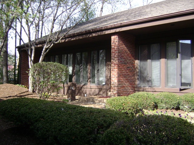
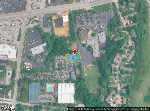
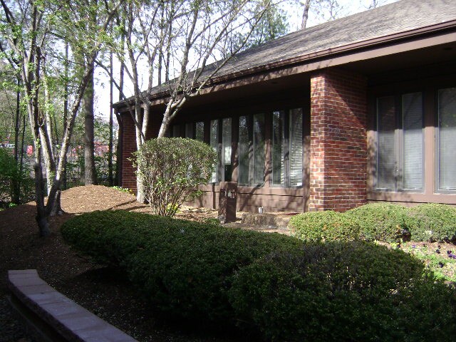

This Property Is For Sale
NEARBY LISTINGS FOR SALE OR LEASE
Property Detail
9 The Pines Ct
16Q-31-1033
Pines Condominium Plat 5 21St Amended
Officecondo
PINES CONDOMINIUM PLAT 5 21ST AMENDED PLAT (THE) BLDG 9 UNIT 43 2.03% IN COMMON ELEMENTS (8429-1446) 7 12 88
X
St. Louis
29189C0186K
Missouri
2024
0.04 AC
2025
I-270/Olive Blvd
215233
St. Louis
1,667 SF
St. Louis, MO-IL
DEMOGRAPHICS near 9 The Pines Ct
1 Mile
3 Mile
5 Mile
2024 Total Population
7,593
48,180
122,850
2029 Population
7,401
47,239
120,837
Pop Growth 2024-2029
(2.53%)
(1.95%)
(1.64%)
Average Age
44
43
43
2024 Total Households
3,377
20,407
51,533
HH Growth 2024-2029
(2.55%)
(1.99%)
(1.71%)
Median Household Inc
$90,662
$98,131
$103,417
Avg Household Size
2.20
2.20
2.30
2024 Avg HH Vehicles
2.00
2.00
2.00
Median Home Value
$334,720
$357,880
$348,857
Median Year Built
1971
1976
1976
Nearby Places
- Restaurants
- Banks
- Shops
- Fitness
- Groceries
PUBLIC TRANSPORTATION
AIRPORT
St Louis Lambert International
DRIVE
WALK
Distance
St Louis Lambert International
23 min
14.1 mi
Freight Ports
Port Milwaukee
DRIVE
WALK
Distance
Port Milwaukee
442 min
387.3 mi
Nearby Properties
Address
Land Use
TOTAL SIZE
Lot Size
Zoning
Address
Land Use
TOTAL SIZE
Lot Size
Zoning
200,372 SF
121.45 AC
105FPNU
Address
Land Use
TOTAL SIZE
Lot Size
Zoning
43,574 SF
55.62 AC
NU
Address
Land Use
TOTAL SIZE
Lot Size
Zoning
3,220 SF
31.26 AC
CB
Address
Land Use
TOTAL SIZE
Lot Size
Zoning
495,011 SF
33.43 AC
Address
Land Use
TOTAL SIZE
Lot Size
Zoning
587,809 SF
36.69 AC
105NU
Address
Land Use
TOTAL SIZE
Lot Size
Zoning
28.46 AC
104NU
Address
Land Use
TOTAL SIZE
Lot Size
Zoning
12,017 SF
122.40 AC
NU
Address
Land Use
TOTAL SIZE
Lot Size
Zoning
26.89 AC
C-8
Address
Land Use
TOTAL SIZE
Lot Size
Zoning
247,860 SF
21.11 AC
105MU
Address
Land Use
TOTAL SIZE
Lot Size
Zoning
272,522 SF
8.70 AC
83POP
Address
Land Use
TOTAL SIZE
Lot Size
Zoning
252,737 SF
24.69 AC
R3
Address
Land Use
TOTAL SIZE
Lot Size
Zoning
337,354 SF
7.40 AC
82CB
Address
Land Use
TOTAL SIZE
Lot Size
Zoning
46,752 SF
3.67 AC
82CB
Address
Land Use
TOTAL SIZE
Lot Size
Zoning
68,279 SF
95.59 AC
NU
Address
Land Use
TOTAL SIZE
Lot Size
Zoning
13.45 AC
PD-M
Address
Land Use
TOTAL SIZE
Lot Size
Zoning
340,320 SF
55.62 AC
NU
Address
Land Use
TOTAL SIZE
Lot Size
Zoning
302,420 SF
13.97 AC
NU
Address
Land Use
TOTAL SIZE
Lot Size
Zoning
1,635 SF
68.83 AC
83E
Address
Land Use
TOTAL SIZE
Lot Size
Zoning
297,247 SF
5.40 AC
82CB
Address
Land Use
TOTAL SIZE
Lot Size
Zoning
200,840 SF
12.29 AC
105C8
Address
Land Use
TOTAL SIZE
Lot Size
Zoning
139,980 SF
15.70 AC
83SE
Address
Land Use
TOTAL SIZE
Lot Size
Zoning
10,644 SF
110.98 AC
82HE
Address
Land Use
TOTAL SIZE
Lot Size
Zoning
42,037 SF
193.91 AC
NU
Address
Land Use
TOTAL SIZE
Lot Size
Zoning
36.41 AC
R2
Address
Land Use
TOTAL SIZE
Lot Size
Zoning
389,367 SF
29.15 AC
R6
Address
Land Use
TOTAL SIZE
Lot Size
Zoning
247,086 SF
11.32 AC
104PDM
Address
Land Use
TOTAL SIZE
Lot Size
Zoning
353,407 SF
21.84 AC
104R-4
Address
Land Use
TOTAL SIZE
Lot Size
Zoning
146,175 SF
1.41 AC
83POP
Address
Land Use
TOTAL SIZE
Lot Size
Zoning
212,180 SF
2.03 AC
83POP
Address
Land Use
TOTAL SIZE
Lot Size
Zoning
216,290 SF
10.39 AC
104MXD
The World's #1 Commercial Real Estate Marketplace
Connect with us
© 2025 CoStar Group
The information above has been obtained from sources believed reliable. While we do not doubt its accuracy we have not verified it and make no guarantee, warranty or representation about it. It is your responsibility to independently confirm its accuracy and completeness. Any projections, opinions, assumptions, or estimates used are for example only and do not represent the current or future performance of the property. The value of this transaction to you depends on tax and other factors which should be evaluated by your tax, financial, and legal advisors. You and your advisors should conduct a careful, independent investigation of the property to determine to your satisfaction the suitability of the property for your needs.